Mears Peak

Last updated
Mears Peak
Mears Peak, Sneffels Range.jpg
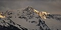
North aspect from Box Factory Park
Highest point
Elevation 13,496 ft (4,114 m) [1]
Prominence 536 ft (163 m) [1]
Parent peak "T 0" (13,735 ft) [2]
Isolation 1.36 mi (2.19 km) [2]
Coordinates 38°00′34″N107°51′43″W / 38.0093395°N 107.8620199°W / 38.0093395; -107.8620199 [3]
Naming
Etymology Otto Mears
Geography
USA Colorado relief location map.svg
Red triangle with thick white border.svg
Mears Peak
Location in Colorado
Usa edcp relief location map.png
Red triangle with thick white border.svg
Mears Peak
Mears Peak (the United States)
Location Ouray County / San Miguel County
Colorado, US
Parent range Rocky Mountains
San Juan Mountains
Sneffels Range [1]
Topo map USGS Mount Sneffels
Geology
Type of rock Extrusive rock, andesitic breccia [4]
Climbing
Easiest route class 2+ scrambling [2]

Mears Peak is a 13,496-foot-elevation (4,114-meter) mountain summit located on the common boundary of Ouray County with San Miguel County, in Colorado, United States. [3] It is situated six miles northwest of the community of Telluride, in the Mount Sneffels Wilderness, on land managed by Uncompahgre National Forest. It is part of the Sneffels Range which is a subset of the San Juan Mountains, which in turn is part of the Rocky Mountains. Mears Peak is situated west of the Continental Divide, and 3.8 miles west of Mount Sneffels. Topographic relief is significant as the south aspect rises 4,900 feet (1,500 meters) above the San Miguel River in approximately 5.5 miles.

Contents

History

This mountain's name and location were officially adopted in 1970 by the U.S. Board on Geographic Names to commemorate Otto Mears (1840–1931). [3] [5] Prior to 1970, the USGS placed Mears Peak at a location one mile to the east. [3] Otto Mears was known for his road and railroad building projects through Colorado's San Juan Mountains, which were instrumental in the early development of southwestern Colorado in the late 19th century. [6] Notably, he built the Million Dollar Highway. There is also a Mount Otto in Colorado named after him.

Climate

According to the Köppen climate classification system, Mears Peak is located in an alpine subarctic climate zone with long, cold, snowy winters, and cool to warm summers. [7] Due to its altitude, it receives precipitation all year, as snow in winter, and as thunderstorms in summer, with a dry period in late spring. Precipitation runoff from the mountain drains south to the San Miguel River, and north to the Uncompahgre River via Dallas Creek.

See also

Related Research Articles

<span class="mw-page-title-main">Dallas Peak</span>

Dallas Peak is a high mountain summit in the Sneffels Range of the Rocky Mountains of North America. The 13,815-foot (4,211 m) thirteener is located in the Mount Sneffels Wilderness of Uncompahgre National Forest, 3.3 miles (5.3 km) north by west of the Town of Telluride, Colorado, United States, on the drainage divide between Ouray and San Miguel counties.

<span class="mw-page-title-main">Gilpin Peak</span> Mountain in the state of Colorado

Gilpin Peak is a high mountain summit in the Sneffels Range of the Rocky Mountains of North America. The 13,700-foot (4,176 m) thirteener is located in the Mount Sneffels Wilderness of Uncompahgre National Forest, 3.5 miles (5.6 km) north-northeast of the Town of Telluride, Colorado, United States, on the drainage divide between Ouray County and San Miguel County. Gilpin Peak was named in honor of William Gilpin, the first Governor of the Territory of Colorado.

<span class="mw-page-title-main">Hayden Peak (San Miguel County, Colorado)</span>

Hayden Peak is a 12,987-foot-elevation (3,958-meter) mountain summit located in San Miguel County, in Colorado, United States. It is situated nine miles northwest of the community of Telluride, in the Mount Sneffels Wilderness, on land managed by Uncompahgre National Forest. It is part of the Sneffels Range which is a subset of the San Juan Mountains, which in turn is part of the Rocky Mountains. Hayden Peak is situated west of the Continental Divide, and three miles northwest of Mears Peak. Topographic relief is significant as the south aspect rises 2,000 feet above Deep Creek in approximately one mile.

<span class="mw-page-title-main">Sunshine Mountain</span>

Sunshine Mountain is a 12,930-foot-elevation (3,940-meter) mountain summit located in San Miguel County, in Colorado, United States. It is situated nine miles southwest of the community of Telluride, in the Lizard Head Wilderness, on land managed by Uncompahgre National Forest. It is part of the San Juan Mountains which is a subset of the Rocky Mountains. Sunshine Mountain is situated 24 miles west of the Continental Divide, 2.75 miles east of Wilson Peak, and 1.8 mile northeast of Lizard Head, the nearest higher neighbor. Topographic relief is significant as the west aspect rises 2,700 feet above Bilk Creek in approximately one mile. The mountain is composed of rock of the San Juan Formation overlaying Telluride Conglomerate, in turn overlaying Mancos Shale. The mountain's name, which has been officially adopted by the United States Board on Geographic Names, was in use before 1899 when Henry Gannett published it in A Dictionary of Altitudes in the United States.

<span class="mw-page-title-main">Precipice Peak</span> Mountain in the state of Colorado

Precipice Peak is a 13,144-foot-elevation (4,006-meter) mountain summit located in Hinsdale County, of Colorado, United States. It is situated 10.5 miles northeast of the community of Ouray, in the Uncompahgre Wilderness, on land managed by Uncompahgre National Forest. It is part of the San Juan Mountains which is a subset of the Rocky Mountains, and is situated west of the Continental Divide. Topographic relief is significant as the west aspect rises 2,500 feet above the West Fork Cimarron River valley in approximately one mile. Neighbors include Dunsinane Mountain three-quarters of a mile north, Courthouse Mountain 2.4 miles northwest, and Redcliff 2.2 miles south. The mountain's name was officially adopted by the United States Board on Geographic Names in 1966. It is so named because of a very prominent precipice on the mountain's east face.

<span class="mw-page-title-main">Potosi Peak</span> Mountain in Colorado, United States

Potosi Peak is a 13,786-foot-elevation (4,202-meter) mountain summit located in Ouray County of Colorado, United States. It is situated five miles southwest of the community of Ouray, on land managed by Uncompahgre National Forest. It is part of the Sneffels Range which is a subset of the San Juan Mountains, which in turn is part of the Rocky Mountains. It is situated west of the Continental Divide, 2.2 miles south of Whitehouse Mountain, and 2.5 miles southeast of Mount Sneffels. Potosi ranks as the 113th-highest peak in Colorado, and the fourth-highest in the Sneffels Range. Recreation enthusiasts heading for Yankee Boy Basin traverse below the southern base of the mountain. Topographic relief is significant as the southeast aspect rises 4,000 feet above the Camp Bird Mine in approximately 1.5 mile. The mining activity in the immediate area produced significant amounts of gold and silver. "Potosi" in Quechuan language translates to "great wealth.". The mountain's name, which has been officially adopted by the United States Board on Geographic Names, was in use before 1899 when Henry Gannett published it in A Dictionary of Altitudes in the United States.

<span class="mw-page-title-main">Mount Emma</span> Mountain in the state of Colorado

Mount Emma is a 13,581-foot-elevation (4,139-meter) mountain summit located in San Miguel County of Colorado, United States. It is situated three miles north of the community of Telluride, on the south side of Yankee Boy Basin, in the Uncompahgre National Forest. It is part of the Sneffels Range which is a subset of the San Juan Mountains, which in turn is part of the Rocky Mountains. Mount Emma is situated west of the Continental Divide, two miles south of Mount Sneffels, and 0.8 mile south of Gilpin Peak, the nearest higher neighbor. Emma ranks as the 197th-highest peak in Colorado, and the 10th-highest in the Sneffels Range. Topographic relief is significant as the south aspect rises 4,830 feet above Telluride in approximately three miles. An ascent of Mt. Emma is a difficult climb with 2,180 feet of elevation gain covering three miles from Yankee Boy Basin, or 4,836 feet of elevation gain from Telluride. This mountain's name was officially adopted by the U.S. Board on Geographic Names.

<span class="mw-page-title-main">Coxcomb Peak (Colorado)</span> Mountain in the state of Colorado

Coxcomb Peak is a 13,656-foot-elevation (4,162-meter) mountain summit located on the common boundary of Hinsdale County and Ouray County, in Colorado, United States. It is situated nine miles northeast of the community of Ouray, in the Uncompahgre Wilderness, on land managed by Uncompahgre National Forest. It is part of the San Juan Mountains which are a subset of the Rocky Mountains, and is situated west of the Continental Divide. Coxcomb ranks as the 171st-highest peak in Colorado, and topographic relief is significant as the south aspect rises 2,000 feet above Wetterhorn Basin in approximately one mile, and 4,400 feet above Cow Creek in three miles. Neighbors include Precipice Peak 2.7 miles to the north, Redcliff one-half mile north, Matterhorn Peak 2.3 miles to the east-southeast, and nearest higher neighbor Wetterhorn Peak 1.8 mile to the southeast. The mountain's descriptive name, which has been officially adopted by the United States Board on Geographic Names, was in use since at least 1906 when Henry Gannett published it in the Gazetteer of Colorado.

<span class="mw-page-title-main">Whitehouse Mountain</span> Mountain in Ouray County, Colorado

Whitehouse Mountain is a 13,492-foot-elevation (4,112-meter) mountain summit located in Ouray County of southwest Colorado, United States. It is situated four miles west of the community of Ouray, on land managed by Uncompahgre National Forest. It is part of the Sneffels Range which is a subset of the San Juan Mountains, which in turn is part of the Rocky Mountains. It is west of the Continental Divide, 2.2 miles north of Potosi Peak, and 3.2 miles east-northeast of Mount Sneffels. Topographic relief is significant as the east aspect rises 5,680 feet above the town of Ouray in approximately four miles. The mountain's name, which has been officially adopted by the United States Board on Geographic Names, was in use before 1906 when Henry Gannett published it in the Gazetteer of Colorado.

<span class="mw-page-title-main">Mount Ridgway</span> Mountain in the state of Colorado

Mount Ridgway is a 13,468-foot-elevation (4,105-meter) mountain summit located in Ouray County of southwest Colorado, United States. It is situated five miles west of the community of Ouray, on land managed by Uncompahgre National Forest. It is part of the Sneffels Range which is a subset of the San Juan Mountains, which in turn is part of the Rocky Mountains. It is west of the Continental Divide, 2.2 miles east-northeast of Mount Sneffels, and 0.95 miles southwest of Whitehouse Mountain, which is the nearest higher neighbor. Topographic relief is significant as the west aspect rises 3,000 feet above Blaine Basin in one mile.

<span class="mw-page-title-main">Stony Mountain (Colorado)</span> Mountain in the state of Colorado

Stony Mountain is a 12,698-foot-elevation (3,870-meter) mountain summit located in Ouray County of southwest Colorado, United States. It is situated five miles southwest of the community of Ouray, on land managed by Uncompahgre National Forest. It is part of the Sneffels Range which is a subset of the San Juan Mountains, which in turn is part of the Rocky Mountains. It is situated west of the Continental Divide, 1.3 miles southwest of Potosi Peak, and 1.15 miles northeast of parent Mount Emma. Yankee Boy Basin is surrounded by Stony Mountain, Gilpin Peak, Mount Sneffels, Cirque Mountain, and Teakettle Mountain. Topographic relief is significant as the east aspect rises 2,000 feet above Sneffels Creek in less than one mile. The mountain's name, which has been officially adopted by the United States Board on Geographic Names, was in use before 1899 when Henry Gannett published it in A Dictionary of Altitudes in the United States.

<span class="mw-page-title-main">Darley Mountain</span>

Darley Mountain is a 13,260-foot-elevation (4,042 meter) mountain summit located on the shared boundary of Hinsdale County with Ouray County, in southwest Colorado, United States. It is situated five miles southeast of the community of Ouray, in the Uncompahgre Wilderness, on land managed by Uncompahgre National Forest. It is part of the San Juan Mountains which are a subset of the Rocky Mountains, and is west of the Continental Divide. Neighboring geographic features include Engineer Pass 0.6 mile to the southeast, Engineer Mountain 0.9 mile to the south, and nearest higher neighbor Wildhorse Peak 2.2 miles to the north. The mountain's name was officially adopted in 1992 by the United States Board on Geographic Names to commemorate George Marshall Darley (1847–1917), pioneering minister of the San Juan Mountains, who founded and built the first church in western Colorado in Lake City in 1876. Lake City is approximately 16 miles east of this mountain.

<span class="mw-page-title-main">United States Mountain</span> Mountain in the state of Colorado

United States Mountain is a 13,036-foot-elevation (3,973-meter) mountain summit located in Ouray County of southwest Colorado, United States. It is situated six miles southwest of the community of Ouray, on land managed by Uncompahgre National Forest. It is part of the Sneffels Range which is a subset of the San Juan Mountains, which in turn is part of the Rocky Mountains. It is set west of the Continental Divide, 2.3 miles south of Potosi Peak, and 2.5 miles southeast of Stony Mountain. Recreation enthusiasts heading for Yankee Boy Basin traverse below the northern base of the mountain. Topographic relief is significant as the north aspect rises 3,300 feet above the Camp Bird Mine in approximately one mile. Mining activity in the immediate area produced significant amounts of gold and silver. The Hidden Treasure Mine is a gold mine located on the south slope at 11,759-feet elevation.

<span class="mw-page-title-main">Cirque Mountain (Colorado)</span> Mountain in Colorado, United States

Cirque Mountain is a 13,686-foot-elevation (4,171-meter) mountain summit located in Ouray County of southwest Colorado, United States. It is situated six miles west of the community of Ouray, above the north side of Yankee Boy Basin, on land managed by Uncompahgre National Forest. It is part of the Sneffels Range which is a subset of the San Juan Mountains, which in turn is part of the Rocky Mountains. Cirque ranks as the 155th-highest peak in Colorado, and the ninth-highest in the Sneffels Range. It is west of the Continental Divide, 1.12 mile east of Mount Sneffels, and 0.59 mile west of Teakettle Mountain, which is the nearest higher neighbor. Topographic relief is significant as the north aspect rises 3,000 feet above Blaine Basin in one mile, and the south aspect rises over 2,000 feet above Yankee Boy Basin in less than one mile. These basins are cirques which were carved by ancient glaciers. The mountain's name has been officially adopted by the United States Board on Geographic Names.

<span class="mw-page-title-main">Abrams Mountain</span> Mountain in the state of Colorado

Abrams Mountain, also known as Mount Abram or Mount Abrams, is a 12,801-foot-elevation (3,902-meter) mountain summit located on the shared boundary of Ouray County with San Juan County in southwest Colorado, United States. It is situated four miles south of the town of Ouray, on land managed by Uncompahgre National Forest. It is part of the San Juan Mountains, which are a subset of the Rocky Mountains, and is west of the Continental Divide. Topographic relief is significant as the north aspect rises 3,800 feet above Uncompahgre Gorge in 1.5 mile. Historic mines are located on the slopes of Abrams Mountain. This iconic feature of the Ouray landscape can be seen for many miles while driving Highway 550 south from Montrose toward Ouray, and it dominates the San Juan Skyway from Red Mountain Pass to Ironton Park.

<span class="mw-page-title-main">Courthouse Mountain</span> Mountain in the state of Colorado

Courthouse Mountain is a 12,152-foot-elevation (3,704-meter) mountain summit located on the shared boundary of Hinsdale County with Ouray County, in southwest Colorado, United States. It is situated 10.5 miles east of the community of Ridgway, and south of Owl Creek Pass, in the Uncompahgre Wilderness, on land managed by Uncompahgre National Forest. It is part of the San Juan Mountains which are a subset of the Rocky Mountains, and is situated west of the Continental Divide. Topographic relief is significant as the east aspect rises nearly 2,000 feet above West Fork Cimarron River in approximately one-half mile, and with its prominence can be seen from Highway 550 near Ridgway. The mountain's name, which has been officially adopted by the United States Board on Geographic Names, was in use before 1906 when Henry Gannett published it in the Gazetteer of Colorado.

<span class="mw-page-title-main">Wildhorse Peak</span> Mountain in the state of Colorado

Wildhorse Peak is a 13,266-foot-elevation (4,043-meter) mountain summit located in Ouray County, of Colorado, United States. It is situated five miles east of the community of Ouray, in the Uncompahgre Wilderness, on land managed by Uncompahgre National Forest. It is part of the San Juan Mountains which are a subset of the Rocky Mountains, and is situated west of the Continental Divide. Neighbors include Darley Mountain 2.2 miles to the south, and Abrams Mountain five miles to the southwest. This distinctive peak abruptly rises 1,000 feet above the alpine tundra of American Flats, and topographic relief is significant as the northwest aspect rises 1,600 feet above Wildhorse Creek in less than one mile. The peak can be seen from Montrose and Highway 550. The first ascent of the summit was made August 25, 1899, by Eli Stanton, F. H. Stanton, and William Killen. The mountain's name, which has been officially adopted by the United States Board on Geographic Names, was in use in 1906 when Henry Gannett published it in A Gazetteer of Colorado.

<span class="mw-page-title-main">Chicago Peak</span> Mountain in the state of Colorado

Chicago Peak is a 13,385-foot-elevation (4,080-meter) mountain summit located on the shared boundary of San Miguel County with Ouray County in southwest Colorado, United States. It is situated four miles (6.4 km) east of the community of Telluride, on land managed by Uncompahgre National Forest. It is part of the Sneffels Range which is a subset of the San Juan Mountains, which in turn are part of the Rocky Mountains. It is set above the ghost town of Tomboy, one mile (1.6 km) south of United States Mountain, and one mile northwest of Imogene Pass. Topographic relief is significant as the east aspect rises 2,000 feet above Imogene Basin in approximately one mile, and the west aspect rises 2,000 feet above Savage Basin in less than one mile. Mining activity in the immediate area produced significant amounts of gold and silver.

<span class="mw-page-title-main">Twin Peaks (Ouray County, Colorado)</span> Mountain in Ouray County, Colorado

Twin Peaks is a 10,970-foot-elevation (3,340-meter) double summit mountain located in Ouray County, Colorado, United States.

<span class="mw-page-title-main">Brown Mountain (Colorado)</span>

Brown Mountain is a 13,347-foot-elevation (4,068-meter) summit located on the boundary shared by Ouray County with San Juan County in Colorado, United States.

References

  1. 1 2 3 "Mears Peak, Colorado". Peakbagger.com.
  2. 1 2 3 "Mears Peak - 13,496' CO". listsofjohn.com. Retrieved 2021-06-27.
  3. 1 2 3 4 "Mears Peak". Geographic Names Information System . United States Geological Survey, United States Department of the Interior . Retrieved 2021-06-27.
  4. Bulletin of the Geological Society of America, Volume 17, 1906, page 262.
  5. Stewart M. Green, Scenic Driving Colorado: Exploring the State's Most Spectacular Back Roads, 2019, Globe Pequot, ISBN   9781493035991, page 254.
  6. Williamson, Ruby G. "Otto Mears Pathfinder of the San Juan: His Family and Friends" (Gunnison, 1981).
  7. Peel, M. C.; Finlayson, B. L.; McMahon, T. A. (2007). "Updated world map of the Köppen−Geiger climate classification". Hydrol. Earth Syst. Sci. 11. ISSN   1027-5606.