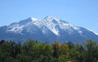
Mount Sopris is a twin-summit mountain in the northwestern Elk Mountains range of the Rocky Mountains of North America. The prominent 12,965-foot (3,952 m) mountain is located in the Maroon Bells-Snowmass Wilderness of White River National Forest, 6.6 miles (10.7 km) north by northeast of the community of Redstone in Pitkin County, Colorado, United States.
Mount Lamborn is a mountain summit in the West Elk Mountains range of the Rocky Mountains of North America. The 11,402-foot (3,475 m) peak is located in Gunnison National Forest, 5.9 miles (9.5 km) southeast by south of the Town of Paonia in Delta County, Colorado, United States. The summit of Mount Lamborn is the highest point in Delta County. Together with nearby Landsend Peak to the southwest, it lies at the western edge of the West Elks, rising dramatically nearly 6,000 ft above the valley of the North Fork Gunnison River to the west.

The West Elk Mountains are a high mountain range in the west-central part of the U.S. state of Colorado. They lie primarily within the Gunnison National Forest, and part of the range is protected as the West Elk Wilderness. The range is primarily located in Gunnison County, with small parts in eastern Delta and Montrose counties.

Crested Butte is a prominent mountain summit in the Elk Mountains range of the Rocky Mountains of North America. The 12,168-foot (3,709 m) peak is in Gunnison National Forest, 2.1 miles (3.4 km) northeast by east of the Town of Crested Butte in Gunnison County, Colorado, United States. Ski lifts and runs of the Crested Butte Mountain Resort occupy the north side of the mountain.
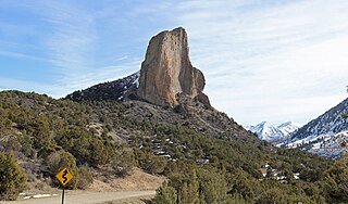
Needle Rock Natural Area is located at the western edge of the West Elk Mountains of Colorado. The surrounding terrain is characterized by laccolithic mountains flanked by precipitous cliffs, extensive talus aprons, forested mesas, canyons, and spacious, well-watered intermontane basins. Needle Rock is an intrusive plug of monzonite porphyry cropping out 3.5 miles (5.6 km) east-northeast of the Town of Crawford in Delta County, Colorado, United States. With an elevation of 7,797 feet (2,377 m), the towering rock spire stands 800 feet (240 m) tall above the floor of the Smith Fork of the Gunnison River valley. The massive rock feature originated in the Oligocene geological epoch when magma intruded between existing sedimentary rocks as the crown of a buried laccolith or possibly the underlying conduit of a laccolith. Subsequent erosion has exposed the prominent rock formation seen in the natural area today.

Tomichi Dome rises north of U.S. Highway 50 west of Hot Springs Creek and south of Waunita Hot Springs Reservoir in the southeast quarter of Gunnison County, Colorado. It is situated within the Gunnison National Forest.
Mount Gunnison is a prominent mountain summit in the West Elk Mountains range of the Rocky Mountains of North America. The 12,725-foot (3,879 m) peak is located in the West Elk Wilderness of Gunnison National Forest, 22.2 miles (35.7 km) west by south of the Town of Crested Butte in Gunnison County, Colorado, United States. The mountain is named in honor of John Williams Gunnison who explored the area.

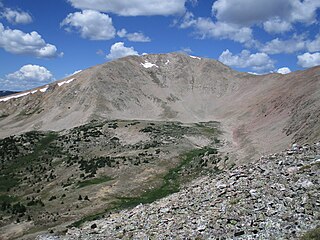
West Elk Peak, elevation 13,042 ft (3,975 m), is the highest summit in the West Elk Mountains of Gunnison County, Colorado. The mountain is in the West Elk Wilderness, northwest of Gunnison. The terrain consists mostly of volcanic breccia, known in this area as West Elk Breccia, dated at 35 to 30 million years old.

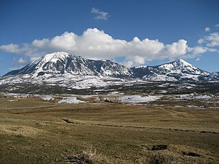
East Beckwith Mountain is a prominent mountain summit in the West Elk Mountains range of the Rocky Mountains of North America. The 12,441-foot (3,792 m) peak is located in the West Elk Wilderness of Gunnison National Forest, 13.4 miles (21.5 km) west by south of the Town of Crested Butte in Gunnison County, Colorado, United States.

Whetstone Mountain, elevation 12,527 ft (3,818 m), is a summit in the Gunnison National Forest of western Colorado. The mountain is located 3 mi (4.8 km) south of Crested Butte in Gunnison County. Whetstone Mountain is one of several prominent laccoliths found in the West Elk Mountains.

Mount Guero is a prominent mountain summit in the West Elk Mountains range of the Rocky Mountains of North America. The 12,058-foot (3,675 m) peak is located in the West Elk Wilderness of the Gunnison National Forest, 13 miles (21 km) east of Crawford, Colorado in Delta County and 24.3 miles (39.1 km) west-southwest of the Town of Crested Butte in Gunnison County, Colorado, United States.

Marcellina Mountain is a prominent mountain summit in the West Elk Mountains range of the Rocky Mountains of North America. The 11,353-foot (3,460 m) peak is located in the Raggeds Wilderness of Gunnison National Forest, 15.0 miles (24.1 km) west by north of the Town of Crested Butte in Gunnison County, Colorado, United States.

Carbon Peak, elevation 12,088 ft (3,684 m), is a summit in the West Elk Mountains of Colorado. The peak is southwest of Crested Butte in the Gunnison National Forest. Carbon Peak is one of several prominent laccoliths found in the West Elk Mountains.
Mount Emmons is a mountain summit in the Elk Mountains range of the Rocky Mountains in north-central Gunnison County, Colorado, United States.

Landsend Peak is a prominent wedge-shaped mountain located in the West Elk Mountains range northeast of Crawford, Colorado. The summit of Landsend Peak has an elevation of 10,806 ft (3,294 m) rising dramatically about 4,000 ft (1,200 m) above the valley below. Together with nearby Mount Lamborn to the northeast, it delineates the western edge of the West Elk Mountains, and the two massifs top out about 1 mile (1.6 km) higher than the adjacent North Fork Gunnison River. Both peaks lie within the Gunnison National Forest near the physiographic boundary of the Rocky Mountains and the Colorado Plateau provinces. Geologically, Landsend Peak and Mount Lamborn are exposed igneous intrusions that geologists call laccoliths.

West Beckwith Mountain is a prominent mountain summit in the West Elk Mountains range of the Rocky Mountains of North America. The 12,185-foot (3,714 m) peak is located in the West Elk Wilderness of Gunnison National Forest, about 16.5 miles (26.5 km) southwest of Crested Butte in Gunnison County, Colorado, United States.

Youngs Peak is a small mountain located on the western side of the West Elk Mountains just east of and overlooking Crawford, Colorado. It has an elevation of 7,424 ft (2,263 m) with about 600 ft (180 m) of vertical relief above the town below. Although much of the mountain is covered with sedimentary rocks, Saddle Mountain is an exposed igneous intrusion that geologists call a laccolith.
Fairview Peak is mountain summit in the Sawatch Range of the Rocky Mountains of North America. The 13,214 feet (4,028 m) mountain is located in Gunnison County, Colorado, and in the Gunnison National Forest.


