| Snowdon Peak | |
|---|---|
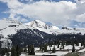
 Northwest aspect | |
| Highest point | |
| Elevation | 13,077 ft (3,986 m) [1] |
| Prominence | 1,317 ft (401 m) [1] |
| Parent peak | Twilight Peak (13,163 ft) [2] |
| Isolation | 3.75 mi (6.04 km) [2] |
| Coordinates | 37°42′28″N107°41′20″W / 37.7078884°N 107.6888976°W [3] |
| Naming | |
| Etymology | Snowdon |
| Geography | |
 Snowdon Peak Location in Colorado  Snowdon Peak Snowdon Peak (the United States) | |
| Location | San Juan County, Colorado, US |
| Parent range | Rocky Mountains San Juan Mountains Needle Mountains [1] |
| Topo map | USGS Snowdon Peak |
| Geology | |
| Rock age | Statherian |
| Rock type | Quartzite |
| Climbing | |
| Easiest route | class 2+ scramble [2] NE ridge [4] |
Snowdon Peak is a 13,077-foot-elevation (3,986-meter) mountain summit located in San Juan County, Colorado, United States. [3] It is situated seven miles south of the community of Silverton, in the Weminuche Wilderness, on land managed by San Juan National Forest. It is part of the San Juan Mountains range which is a subset of the Rocky Mountains of North America, and is set nine miles west of the Continental Divide. Topographic relief is significant as the east aspect rises 4,300 feet (1,300 meters) above the Animas River in approximately 1.5 mile. Neighbors include Mount Garfield three miles to the east-southeast, and Twilight Peak, which is the nearest higher peak, 3.7 miles to the south-southwest. This mountain can be seen from U.S. Route 550. The mountain is named after Snowdon, the highest mountain in Wales. [5]