
The Antonov An-32 is a turboprop twin-engined military transport aircraft. Its first flight was in July 1976 and displayed at the 1977 Paris Air Show. It is oriented towards flying in adverse weather conditions, and was produced from 1980 to 2012, and remains in service. It was developed from the An-24, and the An-26 is related.

Pasighat is the headquarters of East Siang district in the Indian state of Arunachal Pradesh. Situated at the eastern foothills of the Himalayas at 155 metres (509 ft) above mean sea level, Pasighat is Arunachal's oldest town. The Government of India included Pasighat in the Smart Cities Mission development scheme in June 2017.

Aalo, formerly Along, is a census town and headquarter of the West Siang district district of the Indian state of Arunachal Pradesh. It is located 137 kilometres (85 mi) from Likabali, which is at the border of Assam and Arunachal Pradesh.
The Eastern Air Command is one of the five operational commands of the Indian Air Force. Currently headquartered in Shillong in Meghalaya. Named No. 1 Operational Group at the time of its inception, 27 May 1958, it was based at Ranikutir in Kolkata as a part of the Govt's increasing emphasis on defence of the eastern borders. The Operational Group was upgraded as Command on 1 December 1959 with headquarters at Fort William, Kolkata and Air Vice Marshal KL Sondhi as the first AOC-in-C of the Eastern Command. After the 1962 Indo-Chinese War, The decision was made to raise a full-fledged command at Shillong. The area of responsibility of the command now covers 11 states, and is bound by the international boundaries of Nepal, Bhutan, China, Myanmar and Bangladesh incorporating 6300 km of common border. Eastern Air Command now has permanent airbases at Chabua, Guwahati, Bagdogra, Barrackpore, Hasimara, Jorhat, Kalaikunda and Tezpur with forward airbases at Agartala, Kolkata, Panagarh and Shillong. Eastern Air Command consists of Air Defence squadrons consisting of the MiG-21 and Ground attack squadrons consisting of the MiG-27. It holds the motto "Samareshu Parakramaha",
Daporijo Airport is located at Daporijo in the state of Arunachal Pradesh, India. Daporijo used to have scheduled services in the 1980s and early 1990s from Vayudoot. The airport had flights to Guwahati and Dibrugarh on Dornier 228 aircraft. Currently, there is no scheduled commercial air service to the airport, although the airport is used by the Indian Army. The Airports Authority of India (AAI) plans to develop the airport for operation of ATR-42/ATR-72 type of aircraft.
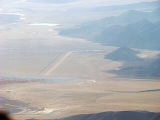
Pasighat Airport is a domestic airport serving Pasighat, Arunachal Pradesh, India. It is located beside the banks of the Brahmaputra River, about 3 km (1.9 mi) away from the town centre.
Zero Airport or Ziro Airport is a domestic airport and an Advanced Landing Ground (ALG) of the Indian Air Force, serving the city of Ziro, Arunachal Pradesh, India. In the past, Vayudoot and Air India operated daily flights to the airport. Now, Alliance Air operates flights to and from the airport.

Thoise or Thoise Air Force Station is a military airfield and small village in Nubra region of Ladakh, India, occupying the only large piece of flat land in the area. The airstrip is a critical facility enabling a quick inflow of men and material from the Indian interior to Siachen, a glacier, helipad and battleground near the Actual Ground Position Line between India and Pakistan.
Fukche Advanced Landing Ground is an airfield in the Demchok sector of the union territory of Ladakh, India. It was built shortly before the 1962 Sino-Indian War and was revived in 2008. It is located adjacent to Koyul, 34 km northwest of Demchok.

Mechukha or Menchukha is a town, assembly constituency and subdivision, situated 6,000 feet (1,829 m) above sea level in the Mechukha Valley of Yargep Chu/ Siyom River in Shi Yomi district of Arunachal Pradesh state of India. Before the 1950s, Mechuka valley was known as Pachakshiri.
Arunachal Frontier Highway (AFH), officially notified as the National Highway NH-913 and also called Bomdila-Vijaynagar Highway (BVH), connecting Bomdila Airstrip ALG & HQ in northwest to Vijaynagar Airstrip ALG & HQ in southeast via Nafra HQ-Sarli HQ-Huri Helipad ALG & HQ-Nacho HQ-Mechuka Airstrip ALG & HQ-Monigong HQ-Jido -Hunli HQ-Hayuliang Airstrip ALG HQ-Chenquenty-Hawai HQ-Miao HQ including 800 km greenfield section and network of new tunnels & bridges, is a 2-lane paved-shoulder under-construction national highway along the India-China LAC-McMahon Line border in the Indian state of Arunachal Pradesh. The 1,748 km-long (1,086 mi) highway itself will cost ₹27,000 crore and total cost including 6 additional inter-corridors is ₹40,000 crore. In some places, this highway will run as close as 20 km from the LAC. To be constructed by MoRTH in 9 packages, all packages will be approved by the end of fy 2024-25 and construction will be completed in 2 years by 31 March 2027. Of the total route, 800km is greenfield, rest brownfield will be upgraded and tunnels will be built. This highway in the north & east Arunachal along the China border, would complement the Trans-Arunachal Highway and the Arunachal East-West Corridor as major highways spanning the whole state, pursuing the Look East connectivity policy.

Vijaynagar is the most remote town and circle headquarters in the Changlang district, Arunachal Pradesh, India.
Tawang Air Force station in Arunachal Pradesh in India has a functional heliport and fixed-wing "Advanced Landing Ground" (AGL) capable of handling Lockheed Martin C-130J Super Hercules transport aircraft. The Indian Air Force (IAF) has since 2016 upgraded 8 ALG in Arunachal Pradesh and made those operation by 2018, all of which has been offered for the operation of civil helicopter and flights for tourism and the UDAN scheme.

Shi Yomi district is one of the 23 districts of Arunachal Pradesh state in northeastern India. Shi-Yomi district was created on 9 December 2018 by dividing the West Siang district when northern areas along the China border were made into a newly created Shi-Yomi district and the remaining southern areas remain the part truncated West Siang district. It has its headquarters at Tato.

On 3 June 2019, an Antonov An-32 twin engine turboprop transport aircraft of the Indian Air Force en route from Jorhat Airport in Assam to Mechuka in Arunachal Pradesh lost contact with ground control about 33 minutes after takeoff. There were 13 people on board. After a week-long search operation, the wreckage with no survivors was found near Pari hills close to Gatte village in Arunachal Pradesh at the elevation of 12,000 feet (3,700 m).
Tuting Advanced Landing Ground is an Indian Air Force airstrip located at Tuting in Upper Siang district of Arunachal Pradesh, India on the banks of River Siang. NH-913 Arunachal Frontier Highway will pass through Jido suburb of Tuting immediately south of the airstrip.
Walong Advanced Landing Ground is an Indian Air Force airstrip located at Walong on the banks of Lohit River in Anjaw District of Arunachal Pradesh, India. It is nearly 50 km north of district headquarter at Hawai, nearly 30 km south of India-China LAC, and 70 km southwest of Diphu Pass near India-China-Myanmar tri-junction.
India–China Border Roads is a Government of India project for developing infrastructure along the Sino-Indian border by constructing strategic roads, including bridges and tunnels. The ICBR project is largely in response to Chinese infrastructure development along the borderlands with India.


