Meigle, North Ayrshire

Last updated

Meigle
Road through Meigle - geograph.org.uk - 735383.jpg
The hamlet of Meigle
North Ayrshire UK location map.svg
Red pog.svg
Meigle
Location within North Ayrshire
OS grid reference NS 1957 6589
Council area
Lieutenancy area
Country Scotland
Sovereign state United Kingdom
Post town Largs
Police Scotland
Fire Scottish
Ambulance Scottish
UK Parliament
Scottish Parliament
List of places
UK
Scotland
55°51′09″N4°53′02″W / 55.85240173°N 4.88388064°W / 55.85240173; -4.88388064 Coordinates: 55°51′09″N4°53′02″W / 55.85240173°N 4.88388064°W / 55.85240173; -4.88388064

Meigle or Meagle [1] is a hamlet on the Meigle Burn in North Ayrshire, Parish of Largs, Scotland. The settlement lies close to the road to Greenock and is named after the bay where the Skelmorlie Burn flows into the Firth of Clyde. Meigle once stood on the old toll road from Largs to Greenock. It lies 41 m (135 ft) above sea level. [2] Skelmorlie Castle and glen lie nearby. The Meigle Burn has its confluence with the Skelmorlie Burns to the east of Skelmorlie Bridge. The modern spelling 'Meigle' will be used for consistency. There is also a village called Meigle in Perth & Kinross.

Contents

History

In the 1750s a mill stood close to the Meigle Burn and Skelmorlie Water, the mills presence surviving as the place-name 'Millburn'. [3]

The first OS maps gives the spelling as 'Meagle'. [4] In 1855-57 Meagle (sic) consisted of a cottage house and buildings leased by the late A.H.Campbell Esq from the Earl of Glasgow. [5]

The old Meigle Chapel. Former church at Meigle - geograph.org.uk - 441632.jpg
The old Meigle Chapel.

Meagle (sic) was an ordinary country school without an endowment, its costs being covered by voluntary Contributions and by the pupils parents. In 1855-57 Mr Lorgan was the teacher. [6]

Meigle Bay is a small and shallow and lies in the Firth of Clyde in front of Skelmorlie Castle. It was a famous haunt of smugglers who found safe hiding places here in the Rocks, Caves and neighbourhood. [7]

In 1876 a chapel was built, using the medium of mass concrete, as a gift from the Stewart sisters of Ashcraig House. It was converted and extended to become a private dwelling. [8] A mission hall is shown on the OS map of 1909. [9] [10]

In 1855 a new road had been built close to the coast and Bridgend House and its grounds stand on the old toll road route. A bathing house is shown on the north side of the Skelmorlie Burn with a footpath leading to it. A school is also shown on the outskirts of the hamlet that served Meigle and the surrounding farms. [1]

In 1909 the post office is no longer shown on OS maps, but a letter box is present as it still is. The school is also not indicated, however the boat house is marked. A mission hall is however still present. [9]

Transport

The old road in the 1750s from Largs to Greenock via Inverkip used to run mainly inland, close to Skelmorlie Castle on its eastern side, crossing a rather narrow Bridge over Skelmorlie Water [5] and then running further inland via Knock Castle to Largs, Irvine, etc. [3] With the establishment of the coast road a new bridge was built over the Skelmorlie Water and the old bridge and that section of the old road became an entrance to Bridgend House. The 1832 Thomson's map shows the new coastal toll road with a new bridge at Meagle (sic) named Haining Bridge End. [11]

The Serpent Mound

Above the hamlet lies the 'Serpent Mound', named after the curved shape of the earthwork. It is said to have been had connections with the cult of sun worship. [8] Smith records that despite the serpentine shape it is a natural stratified structure formed from stratified deposits on the old raised beach eroded by streams that run on either side. [12] A Dr Phenè discovered this structure and excavations revealed a paved platform shaped like a segment of a circle, together with many bones and charcoal. [13] As stated, the mound itself may well be entirely natural; however, the paved platform is a genuine artifact; it is not listed by the relevant authorities. [14]

Ashcraig House

The Victorian letterbox Post Box - geograph.org.uk - 440719.jpg
The Victorian letterbox

Ashcraig House on the Firth of Clyde had a boat house and a bathing house. Spacious formal gardens are overlooked by a circa 1840 pink stone marine villa. [1] [10]

Etymology

The place-name Meigle in Perth and Kinross may be from the Old English for 'midge gill'. The Meigle hamlet in North Ayrshire that has links with the Scandinavian influences that are common on the west coast of Scotland, is thought to be derived from the Norse ' mjo gil' meaning 'narrow gill' or 'narrow opening'. [15]

Meigle Bay

One of the markers for the 'Arran Measured Mile' is located on the beach at Meigle. In the 19th century a boat house and bathing houses were located here.

Related Research Articles

Ayrshire Historic county in Scotland

Ayrshire is a historic county and registration county in south-west Scotland, located on the shores of the Firth of Clyde. Its principal towns include Ayr, Kilmarnock and Irvine and it borders the counties of Renfrewshire and Lanarkshire to the north-east, Dumfriesshire to the south-east, and Kirkcudbrightshire and Wigtownshire to the south. Like many other counties of Scotland it currently has no administrative function, instead being sub-divided into the council areas of North Ayrshire, South Ayrshire and East Ayrshire. It has a population of approximately 366,800.

North Ayrshire Council area of Scotland

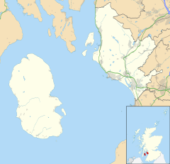
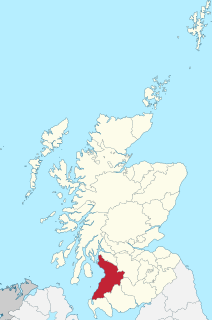
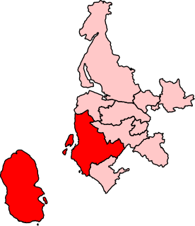
North Ayrshire is one of 32 council areas in Scotland.

Inverclyde Council area of Scotland

Inverclyde is one of 32 council areas used for local government in Scotland. Together with the East Renfrewshire and Renfrewshire council areas, Inverclyde forms part of the historic county of Renfrewshire, which currently exists as a registration county and lieutenancy area – located in the west central Lowlands. It borders the North Ayrshire and Renfrewshire council areas, and is otherwise surrounded by the Firth of Clyde.

Firth of Clyde Inlet on the west coast of Scotland

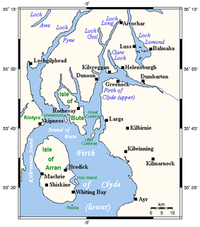
The Firth of Clyde is the mouth of the River Clyde. It is located on the west coast of Scotland and constitutes the deepest coastal waters in the British Isles. The firth is sheltered from the Atlantic Ocean by the Kintyre peninsula, which encloses the outer firth in Argyll and Ayrshire. The Kilbrannan Sound is a large arm of the Firth of Clyde, separating the Kintyre Peninsula from the Isle of Arran. Within the Firth of Clyde is another major island – the Isle of Bute. Given its strategic location at the entrance to the middle and upper Clyde, Bute played a vital naval military role during World War II.

Skelmorlie Human settlement in Scotland

Skelmorlie is a village in North Ayrshire in the south-west of Scotland. Although it is the northernmost settlement in the council area of North Ayrshire, it is contiguous with Wemyss Bay, which is in Inverclyde. The dividing line is the Kelly Burn, which flows into the Firth of Clyde just south of the Rothesay ferry terminal. Despite their proximity, the two villages have historically been divided, Skelmorlie in Ayrshire and Wemyss Bay in Renfrewshire.

Largs Town in Scotland

Largs is a town on the Firth of Clyde in North Ayrshire, Scotland, about 33 miles (53 km) from Glasgow. The original name means "the slopes" in Scottish Gaelic.

County of Bute Historic county in Scotland

The County of Bute, also known as Buteshire, is a historic county and registration county of Scotland.

Wemyss Bay Human settlement in Scotland

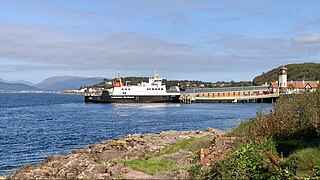
Wemyss Bay is a village on the coast of the Firth of Clyde in Inverclyde in the west central Lowlands of Scotland. It is in the traditional county of Renfrewshire. It is adjacent to Skelmorlie, North Ayrshire. The villages have always been in separate counties, divided by the Kelly Burn.

Fairlie, North Ayrshire Human settlement in Scotland

Fairlie is a village in North Ayrshire, Scotland.

West Kilbride Village in North Ayrshire, Scotland

West Kilbride is a village in North Ayrshire, Scotland, on the west coast by the Firth of Clyde, looking across the Firth of Clyde to Goat Fell and the Isle of Arran. West Kilbride and adjoining districts of Seamill and Portencross are generally considered to be a small town, having a combined population of 4,393 at the 2001 census.

Inverkip Human settlement in Scotland

Inverkip is a village and parish in the Inverclyde council area and historic county of Renfrewshire in the west central Lowlands of Scotland, 5 miles (8 km) southwest of Greenock and 8.1 miles (13 km) north of Largs on the A78 trunk road. The village takes its name from the River Kip and is served by Inverkip railway station.

Greenock West railway station Railway station in Greenock, Inverclyde, Scotland

Greenock West railway station is a station in Greenock, Scotland, located on the Inverclyde Line which runs from Gourock to Glasgow Central. The route is currently operated by Abellio ScotRail under the auspices of Strathclyde Partnership for Transport. Each service to and from Glasgow on the Inverclyde Line stops at this station.

Cunninghame North (Scottish Parliament constituency) Region or constituency of the Scottish Parliament

Cunninghame North is a constituency of the Scottish Parliament (Holyrood) covering part of the council area of North Ayrshire. It elects one Member of the Scottish Parliament (MSP) by the first past the post method of election. It is also one of ten constituencies in the West Scotland electoral region, which elects seven additional members, in addition to the ten constituency MSPs, to produce a form of proportional representation for the region as a whole.

Skelmorlie Castle

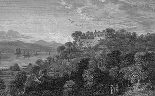
Skelmorlie Castle stands on the eastern shore of the Firth of Clyde, Scotland, at the north-western corner of the county of Ayrshire. The structure dates from 1502, and was formerly the seat and stronghold of the Montgomery Clan. The modern village of Skelmorlie lies to the north of the castle.

Burnhouse Human settlement in Scotland

Burnhouse, sometimes known locally as The Trap from "Man Trap", is a small village or hamlet in North Ayrshire, Parish of Beith, Scotland. It lies on a crossroads of old B706 and the more recent A736 Lochlibo Road, between Lugton and Torranyard.

Kingsford, East Ayrshire Human settlement in Scotland

Kingsford is a hamlet or clachan in Strathannick, East Ayrshire, parish of Stewarton, Scotland. The habitation is situated on the B769, two miles north of Stewarton and fourteen miles from Glasgow.

Loans, South Ayrshire Human settlement in Scotland

Loans is a village in South Ayrshire near Troon, Scotland. It is located in Dundonald parish on the A759 at the junction with the B746 and a minor road to Dundonald.

Minishant Human settlement in Scotland

Minishant is a village bordering the A77 in the old county of Carrick, South Ayrshire, Scotland. It is located in Maybole Parish, 3+12 miles from Maybole and standing close to the River Doon. The village was originally named Culroy after the Culroy Burn that runs through it.

Lawthorn Human settlement in Scotland

Lawthorn is a hamlet near Perceton in Strathannick, Irvine, North Ayrshire, Scotland. The settlement lies on the old Irvine to Stewarton toll road.

References

Notes
  1. 1 2 3 4 Ayrshire, Sheet I, Surveyed: 1855, Published: 1857
  2. OS Survey Meigle, North Ayrshire
  3. 1 2 Roy Lowlands
  4. Rothesay (29), Revised: 1895, Published: 1897
  5. 1 2 Ayrshire OS Name Book. Volume 42.
  6. Ayrshire OS Name Book. Volume 42.
  7. Records Ordnance Survey Name Books Ayrshire OS Name Books, 1855-1857 Ayrshire volume 42 OS1/3/42/32
  8. 1 2 Love, Dane (2003). Ayrshire : Discovering a County. Ayr : Fort Publishing. ISBN   0-9544461-1-9. p.9
  9. 1 2 Ayrshire I.11 (Largs) Publication date:1910 Revised:1909
  10. 1 2 Close, Rob and Riches, Anne (2012). The Buildings of Scotland : Ayrshire and Arran. London : Yale University Press. p. 539.
  11. John Thomson's Atlas of Scotland, 1832
  12. Smith, John (1895). Prehistoric Man in Ayrshire. London : Elliot Stock. p.1.
  13. Harvey, Page 95
  14. Smart, Page 6
  15. Johnston, James B. (1934). Place-Names of Scotland. London:John Murray. p.250
Sources