
Kilmarnock is a large town and former burgh in East Ayrshire, Scotland and is the administrative centre of East Ayrshire Council. With a population of 46,770, Kilmarnock is the 14th most populated settlement in Scotland and the largest town in Ayrshire by population. The town is continuous to nearby neighbouring villages Crookedholm and Hurlford to the east, and Kilmaurs to the west of the town. It includes former villages subsumed by the expansion of the town such as Bonnyton and new purpose built suburbs such as New Farm Loch. The town and the surrounding Greater Kilmarnock area is home to 32 listed buildings and structures designated by Historic Environment Scotland.

Troon is a town in South Ayrshire, situated on the west coast of Ayrshire in Scotland, about eight miles north of Ayr and three miles northwest of Glasgow Prestwick Airport.

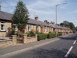
Kilmaurs is a village in East Ayrshire, Scotland which lies just outside of the largest settlement in East Ayrshire, Kilmarnock. It lies on the Carmel Water, 21 miles southwest of Glasgow. Population recorded for the village in the 2001 Census recorded 2,601 people resided in the village It was in the Civil Parish of Kilmaurs.
The Kilmarnock and Troon Railway was an early railway line in Ayrshire, Scotland. It was constructed to bring coal from pits around Kilmarnock to coastal shipping at Troon Harbour, and passengers were carried.

Drybridge railway station was a railway station serving the village of Drybridge, North Ayrshire, Scotland.
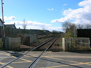
Gatehead railway station was a railway station serving the village of Gatehead, East Ayrshire, Scotland.
Thorntoun School was opened by Barnardo's in September 1971 for children with emotional difficulties aged 11 to 16 years. The school closed in 1990 and Thorntoun is now a nursing home. The complex lies between the villages of Springside and Crosshouse, Kilmarnock in East Ayrshire, Scotland. The old Thorntoun mansion house was demolished in the late 1960s, leaving the West Lodge, some of the home farm outbuildings, the stables and the walled garden as 'memorials' to the ancient history of the site. Many fine trees remain from the estate policies and the surviving gardens are very well maintained (2007). An entrance with a slight deviation from the old course has been created to serve the large modern buildings which house the nursing home.

Laigh Milton Viaduct is a railway viaduct near Laigh Milton mill to the west of Gatehead in East Ayrshire, Scotland, about five miles west of Kilmarnock. It is probably the world's earliest surviving railway viaduct on a public railway, and the earliest known survivor of a type of multi-span railway structure subsequently adopted universally.
The village or hamlet of Gatehead is located in East Ayrshire, Parish of Kilmaurs, Scotland. It is one and a quarter miles from Crosshouse and one and a half miles from Kilmarnock. In the 18th and 19th centuries the locality was a busy coal mining district. The settlement runs down to the River Irvine where a ford and later a bridge was located.

Springside is a village in the parish of Dreghorn, in the council area of North Ayrshire, Scotland. It is three miles from Irvine, 1+1⁄2 miles west of Crosshouse, and four miles from Kilmarnock. In the 18th, 19th and mid-20th centuries, the locality was a highly industrialised coal mining district. The settlement is on the Garrier Burn, which forms the boundary with East Ayrshire. Springside had a population of around 1364 in 1991. The A71 now bypasses the village, 1⁄4 mile to the south.
Knockentiber is a village in East Ayrshire, Parish of Kilmaurs, Scotland. Knockentiber is two miles west-northwest of Kilmarnock and 1⁄2 mile northeast of Crosshouse. Latitude:55.6193°N Longitude:4.5455°W and grid reference NS397392. The population was 359 in 1991, however the population is much higher following the construction of several housing estates (2007). In the 18th and 19th and mid 20th centuries the locality was a highly industrialised coal mining district. The settlement is on the Carmel Burn, which runs into the River Irvine, around one mile to the south.

The River Irvine is a river that flows through southwest Scotland. Its watershed is on the Lanarkshire border of Ayrshire at an altitude of 810 feet (250 m) above sea-level, near Loudoun Hill, Drumclog, and 7 miles SW by W of Strathaven. It flows 29+1⁄2 mi (47.5 km) westward, dividing the old district of Cunninghame from that of Kyle, until it reaches the sea via Irvine Harbour in the form of the Firth of Clyde, and flows into Irvine Bay by the town of Irvine. It has many tributaries, some of which form parish, district and other boundaries.
Lugar is a small village in East Ayrshire, southwest Scotland. Lugar is in Auchinleck Parish, Kyle District, Ayrshire. It is 1.5 miles (2.4 km) ENE of Cumnock, and about 1-mile (1.6 km) from Cronberry and 2 miles (3.2 km) from Gaswater. Lugar was a station on the Mauchline and Muirkirk branch of the Glasgow and South Western Railway. Lugar is about 16.5 miles (26.6 km) SE of Kilmarnock.

Barrmill is a small village in North Ayrshire, Scotland about 1+1⁄2 miles east of Beith on the road to Burnhouse and Lugton. Locally it is known as the Barr.

Crosbie Castle and the Fullarton estate lie near Troon in South Ayrshire. The site was the home of the Fullarton family for several centuries. The lands were part of the feudal Barony of Corsbie Fullartoune (sic). The Crosbie Castle ruins were eventually used as an ice house after the new Fullarton House mansion was built. The mansion house was later demolished and the area set aside as a public park and golf course.

The Galrigs Loch was a substantial freshwater loch situated in low lying area between Newfield and Dundonald in South Ayrshire, Scotland. It was drained in the early 18th century.

Shewalton House and estate were composed of the 'Lands of Shewalton' and the laird's dwelling, originally a tower castle and later a mansion house on the River Irvine in the Shewalton area, two miles from Irvine and west of Drybridge village, East Ayrshire, Dundonald Parish, Scotland. In 1883 the Boyle's estate of Shewalton was 2,358 acres in extent in Ayrshire and was worth at that time £2,708 a year.
The old village or hamlet of Old Rome, Rome or Old Rome Ford is located in South Ayrshire, Parish of Dundonald, Scotland. It is one and a half miles from Crosshouse and one and less than a quarter of a mile from Gatehead. In the 18th and 19th centuries the locality was a busy coal mining district and many of the houses have been demolished. The settlement is situated near the River Irvine.
