The Hurlers (stone circles)

Last updated

The Hurlers
Native name
Cornish: An Hurlysi
Hurlers 2017.jpg
TypeStone circles
Location Minions
Coordinates 50°30′59″N4°27′29″W / 50.5164°N 4.458°W / 50.5164; -4.458
OS grid reference SX 25784 71374
Area Bodmin Moor
Governing body Cornwall Heritage Trust
Owner English Heritage
Official nameThe Hurlers: three stone circles with paired outlying stones
Designated9 October 1981
Reference no. 1008117
Cornwall UK location map.svg
Red pog.svg
Location of The Hurlers in Cornwall


Standing stones in the middle circle of The Hurlers Hurlers2.jpg
Standing stones in the middle circle of The Hurlers
The Hurlers from the north Hurlers.jpg
The Hurlers from the north
The north circle Hurlers1.jpg
The north circle
Map of the stone circles Hurlers3.jpg
Map of the stone circles

The Hurlers (Cornish: An Hurlysi [1] ) is a group of three stone circles in the civil parish of St Cleer, Cornwall, England, UK. The site is half-a-mile (0.8 km) west of the village of Minions on the eastern flank of Bodmin Moor, and approximately four miles (6 km) north of Liskeard. [2]

Contents

Location

The Hurlers are north of Liskeard near the village of Minions on the southern edge of Bodmin Moor in east Cornwall. Just to the west of the circles are two standing stones known as the Pipers. Nearby are Rillaton Barrow and Trethevy Quoit, an entrance grave from the Neolithic period. The Hurlers are managed by the Cornwall Heritage Trust on behalf of English Heritage. [3]

Origin of the name

The name "Hurlers" derives from a legend, in which men were playing Cornish hurling on a Sunday and were magically transformed into stones as punishment. [4] The "Pipers" are supposed to be the figures of two men who played tunes on a Sunday and suffered the same fate. [5] According to another legend, it is impossible to accurately count the number of standing stones. [6]

Construction

Plan of the Hurlers, 1906 The Victoria history of the county of Cornwall (1906) (14774491671).jpg
Plan of the Hurlers, 1906

The Hurlers comprises three stone circles that lie on a line from SSW to NNE, and have diameters of 35 metres (115 ft), 42 metres (138 ft) and 33 metres (108 ft). The two outer stone circles are circular. The middle circle, the largest is slightly elliptical. The survival of the southern stone circle, which now contains nine stones, has been most precarious: only two of the remaining stones are upright and the other seven are partially covered with soil. [5] In the middle circle 14 stones survive out of 28. [5] The stones show clear traces of being hammered smooth. [5] The northern stone circle contained around 30 standing stones, from which 15 are still visible. [5] Two other monoliths, the Pipers, are 100 metres (330 ft) southwest of the middle circle and may be entrance stones to the Hurlers. [7]

Early accounts

The earliest mention of the Hurlers was by historian John Norden, who visited them around 1584. [8] They were described by William Camden in his Britannia of 1586. [8] In 1754 William Borlase published the first detailed description of the site. [9]

Excavations

Ralegh Radford excavated the site in the 1930s, and partly restored the two northern circles by re-erecting some stones and placing marker stones in the positions of those missing. [10] [11] Archives from the unpublished excavation reports have been re-evaluated by Jacky Nowakowski (Cornwall Archaeological Unit) and John Gould (English Heritage) and may result in more analysis and publication. [12]

There have been several subsequent investigations. Between 1975 and 1985 aerial survey and subsequent analysis by various teams, (including Cambridge University, University College London, RCHME and co-ordinated by Cornwall Archaeology Unit) was used to identify and map the features. [13] English Heritage conducted a geophysical survey in 2004. A survey by the Cornwall Archeological Unit in 2009 indicated that there might also be a fourth circle and two stone rows. [14]

The Hurlers was protected as a scheduled monument in 1981, [15] and the protected area was extended in 1994 to include the Pipers. [16]

Alignments

In 1967 Scottish engineer Alexander Thom suggested borderline case alignments at the Hurlers. He suggested two solar alignments of four stones with far uprights. He suggested two stone-to-site alignments with Vega and Arcturus and two other site-to-site alignments with Arcturus. Each stellar alignment was given with tabulated declinations at a date some time in between the range of 2100 to 1500 BC. [17]

Cornwall Heritage Trust

In 1999 there was controversy regarding the site and others under the care of English Heritage. Members of a pressure group, the Revived Cornish Stannary Parliament, removed signs bearing the English Heritage name. [18] [19] After this action several smaller sites, including The Hurlers, Dupath Well, Tregiffian Burial Chamber, St Breock Downs Monolith, King Doniert's Stone, Trethevy Quoit and Carn Euny, were transferred to the management of the Cornwall Heritage Trust. [20]

The Hurlers are the subject of a 2008 song by Devon singer, Seth Lakeman. [21]

Related Research Articles

<span class="mw-page-title-main">Bodmin Moor</span> Granite moorland in northeast Cornwall, England

<span class="mw-page-title-main">The Merry Maidens</span> Late Neolithic stone circle in Cornwall, England

The Merry Maidens, also known as Dawn's Men is a late neolithic stone circle located 2 miles (3 km) to the south of the village of St Buryan, in Cornwall, England. A pair of standing stones, The Pipers is associated both geographically and in legend.

<span class="mw-page-title-main">Trethevy Quoit</span> Dolmen in the Cornwall region, England

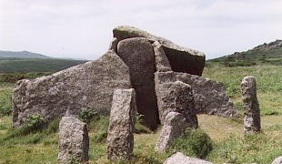
Trethevy Quoit is a well-preserved megalithic structure between St Cleer and Darite in Cornwall, United Kingdom. It is known locally as "the giant's house". Standing 9 feet (2.7 m) high, it consists of five standing stones capped by a large slab and was added to the Heritage at Risk Register in 2017.

<span class="mw-page-title-main">Nine Maidens stone row</span> Neolithic stone row in Cornwall, England

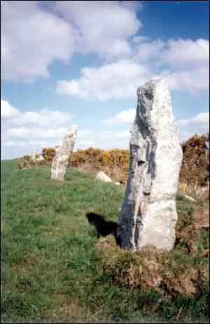
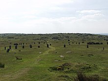
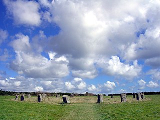
Nine Maidens stone row is an ancient monument in the parish of St Columb Major, Cornwall, England. The Nine Maidens are also known in Cornish as Naw-voz, or Naw-whoors meaning "the nine sisters". This late neolithic stone row is 2 miles (3.2 km) north of St Columb Major.

<span class="mw-page-title-main">St Cleer</span> Village and civil parish in Cornwall, England

<span class="mw-page-title-main">Minions, Cornwall</span> Human settlement in England

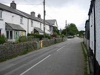
Minions is a village in Cornwall, England, United Kingdom. It is situated on the eastern flank of Bodmin Moor northwest of Caradon Hill approximately four miles (6 km) north of Liskeard. Minions is first recorded in 1613 and its meaning is unknown.

<span class="mw-page-title-main">Zennor Quoit</span> Dolmen in the Cornwall region, England

Zennor Quoit is a ruined megalithic burial chamber or dolmen, located on a moor about a mile (1.6 km) east of the village of Zennor, Cornwall, England, UK. It dates to 2500–1500 BC. Aside from the 12.5-tonne (12,500 kg) roof, which collapsed some time between 1770 and 1865, the chamber is in good condition.

<span class="mw-page-title-main">Craddock Moor stone circle</span> Stone circle on Bodmin Moor, Cornwall, England

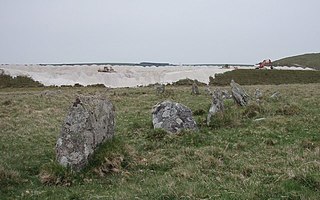
Craddock Moor Stone Circle or Craddock Moor Circle is a stone circle located near Minions on Bodmin Moor in Cornwall, UK. It is situated around half a mile Northwest of The Hurlers.

<span class="mw-page-title-main">Stannon stone circle</span> Stone circle on Bodmin Moor, Cornwall, England

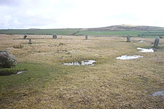
Stannon stone circle is a stone circle located near St. Breward on Bodmin Moor in Cornwall, England.

<span class="mw-page-title-main">The Pipers</span> Standing stones on Bodmin Moor in Cornwall, England

The Pipers are a pair of standing stones near The Hurlers stone circles, located on Bodmin Moor near the village of Minions, Cornwall, UK. They share the name with another pair of standing stones near the Merry Maidens to the south of the village of St Buryan, also in Cornwall.

<span class="mw-page-title-main">Fernacre</span> Stone circle on Bodmin Moor, Cornwall, England

Fernacre, also known as Fernacre stone circle or Fernacre circle, is a stone circle located on the slopes of the De Lank River, 1.25 miles (2.01 km) northeast of St Breward on Bodmin Moor in Cornwall in the United Kingdom.

Goodaver, Goodaver stone circle or Goodaver circle is a stone circle located in the parish of Altarnun, near Bolventor on Bodmin Moor in Cornwall.

<span class="mw-page-title-main">Trippet stones</span> Stone circle on Bodmin Moor, Cornwall, England

The Trippet stones or Trippet stones circle is a stone circle located on Manor Common in Blisland, 9 kilometres (5.6 mi) north northeast of Bodmin on Bodmin Moor in Cornwall, UK. The Stripple stones are nearby.

<span class="mw-page-title-main">Nine Stones, Altarnun</span> Stone circle on Bodmin Moor in Cornwall, England

The Nine Stones is a stone circle 3 kilometres (1.9 mi) south southeast of Altarnun, 11 kilometres (6.8 mi) west of Launceston on Bodmin Moor in Cornwall, UK.

<span class="mw-page-title-main">Brown Willy</span> Highest point in Cornwall, England

Brown Willy is a hill in Cornwall, England, United Kingdom. The summit, at 1,378 feet above sea level, is the highest point of Bodmin Moor and of Cornwall as a whole. It is about 2+12 miles northwest of Bolventor and 4 miles southeast of Camelford. The hill has a variable appearance that depends on the vantage point from which it is seen. It bears the conical appearance of a sugarloaf from the north but widens into a long multi-peaked crest from closer range.

The Cornwall Heritage Trust (CHT) is an organisation which owns and manages historic sites in Cornwall, England. It was founded in 1985.

<span class="mw-page-title-main">Outline of Cornwall</span> Overview of and topical guide to Cornwall

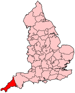
The following outline is provided as an overview of and topical guide to Cornwall: Cornwall – ceremonial county and unitary authority area of England within the United Kingdom. Cornwall is a peninsula bordered to the north and west by the Celtic Sea, to the south by the English Channel, and to the east by the county of Devon, over the River Tamar. Cornwall is also a royal duchy of the United Kingdom. It has an estimated population of half a million and it has its own distinctive history and culture.

Presented below is an alphabetical index of articles related to Cornwall:

<span class="mw-page-title-main">Lesquite Quoit</span> Portal dolmen in Cornwall, United Kingdom

Lesquite Quoit, is a portal dolmen, located near Lanivet in Cornwall, United Kingdom. It is a ceremonial funerary monument built around 3500 - 2600 BC and used by Britain's early farming communities. There are only 20 portal dolmens surviving in the United Kingdom. Many have suffered from stone-robbing and degradation over time. This example is well preserved, and is a scheduled monument. In 1870, J. Polsue recorded that the local tradition was of the stones "having been thrown to their present location from Helman Tor by the Devil playing quoits."

Leskernick Hill is on Bodmin Moor in Cornwall, UK. It is 329m high and has grid reference SX183803. Leskernick Hill is within the Cornwall AONB as part of Area 12: Bodmin Moor in the parish of Altarnun. It lies in an area of moorland that is common land. Its parent hill is Brown Willy and it is within sight of Rough Tor and other local tors

References

  1. ""Place names in the SWF" at magakernow.org.uk". Archived from the original on 15 May 2013. Retrieved 11 September 2012.
  2. Ordnance Survey: Landranger map sheet 201 Plymouth & Launceston ISBN   978-0-319-23146-3
  3. Sites Managed and Cared for by Cornwall Heritage Trust for English Heritage Archived 12 March 2011 at the Wayback Machine
  4. Westwood, Jennifer (1985), Albion. A Guide to Legendary Britain. London : Grafton Books. ISBN   0-246-11789-3. p. 21.
  5. 1 2 3 4 5 The Hurlers Stone Circles: History and Research, English Heritage
  6. The Hurlers, www.stone-circles.org.uk
  7. www.historic-cornwall.org.uk
  8. 1 2 M. V. Taylor, Francis Haverfield, Louis Francis Salzman, 1906, The Victoria History of the County of Cornwall: Volume 1, p. 399
  9. William Borlase (1754) Antiquities Historical and Monumental of the County of Cornwall, London: Bowyer and Nichols
  10. R. Radford 1939 Proceedings of the Prehistoric Society
  11. cornisharchaeology.org
  12. Cornwall Archaeology newlsetter no: 123, June 2010
  13. Bodmin Moor: An archaeological survey - Volume 1
  14. Cornwall County Council, Cornwall Archaeological Unit; Nowakowski, J., Gould, J., Gossip, J. & Buck, C. / 2010 / The Hurlers, Cornwall: archaeological assessment and scoping study 2009 / Report No 09R062
  15. Historic England. "Details from listed building database (1008117)". National Heritage List for England . Retrieved 30 August 2014.
  16. Heritage Gateway:- The Hurlers: three stone circles with paired outlying stones
  17. Alexander Thom (1967). Megalithic Sites in Britain, p. 100. Oxford Univ Pr on Demand. ISBN   978-0-19-813148-9.
  18. Cornish Stannary Parliament tackles English cultural aggression in Cornwall.
  19. BBC News: Historic signs case trio bound over
  20. Cornwall Heritage Trust
  21. The Hurlers - Seth Lakeman Official Music Video on YouTube

Further reading