Filitosa

Last updated

Filitosa Filitosa.jpg
Filitosa
Filitosa Megalithfigur in Filitosa.jpg
Filitosa
Filitosa V Filitosa V JPG2.jpg
Filitosa V

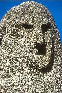
Filitosa is a megalithic site in southern Corsica, France. The period of occupation spans from the end of the Neolithic era and the beginning of the Bronze Age, until around the Roman times in Corsica.

Contents

Location

Back of Statue Menhir Filitosa VI tiarescott 2004.jpg
Back of Statue Menhir

The site lies on road D57, a few hundred metres from the hamlet of Filitosa, 5 km west of Sollacaro, in the canton of Petreto-Bicchisano, arrondissement of Sartène, [1] north of Propriano in the Corse-du-Sud département . It is located on a hill, overlooking the Taravo valley.

Site history and features

The site was discovered in 1946 by the owner of the land, Charles-Antoine Cesari, and brought to the attention of archeologists by the British writer, Dorothy Carrington (see her masterpiece, Granite Island: Portrait of Corsica, [2] ). Systematic excavations started in 1954 by Roger Grosjean. Finds of arrow heads and pottery date earliest inhabitation to 3300 BC. Around 1500 BC, 2-3 metre menhirs were erected. They have been carved with representations of human faces, armour and weapons. Roger Grosjean thought the menhirs may have been erected to ward off an invasion of a group of people called the Torréens (Torreans). However this was unsuccessful: the menhirs were cast down, broken up and reused in some cases as building material by the Torréens. The Torréens built circular stone structures on the site, known as torri (or torre), which may have been used as temples. The torri are remarkably well preserved. This theory had been disputed by later works of F. De Lanfranchi, M.C. Weiss and Gabriel Camps. [3]

In total, about twenty menhirs of various times were counted in Filitosa. They constitute approximately half of the total staff of these monuments in Corsica.

Layout

The site of Filitosa is approached down a track through an ancient olive grove. The first monument to be seen is a rock overhang and surrounding wall. Then the visitor comes upon the central monument. Various hut platforms are all around, and the track leads a further 50m to the Western Monument or torri. From there, one can enjoy a view down the hill to a stone alignment of five megaliths, set around the base of a 2000-year-old olive tree. Behind the olive tree is the quarry from which the megaliths were extracted.

Related Research Articles

<span class="mw-page-title-main">Menhir</span> Large upright standing stone

A menhir, standing stone, orthostat, or lith is a large upright stone, emplaced in the ground by humans, typically dating from the European middle Bronze Age. They can be found individually as monoliths, or as part of a group of similar stones. Menhirs' size can vary considerably, but they often taper toward the top.

<span class="mw-page-title-main">Megalith</span> Large stone used to build a structure or monument

A megalith is a large stone that has been used to construct a prehistoric structure or monument, either alone or together with other stones. There are over 35,000 in Europe alone, located widely from Sweden to the Mediterranean sea.

<span class="mw-page-title-main">Locmariaquer</span> Commune in Brittany, France

Locmariaquer is a commune in the Morbihan department in Brittany in north-western France.

<span class="mw-page-title-main">Carnac stones</span> Set of megalithic sites in Brittany, France

The Carnac stones are an exceptionally dense collection of megalithic sites near the south coast of Brittany in northwestern France, consisting of stone alignments (rows), dolmens, tumuli and single menhirs. More than 3,000 prehistoric standing stones were hewn from local granite and erected by the pre-Celtic people of Brittany and form the largest such collection in the world. Most of the stones are within the Breton municipality of Carnac, but some to the east are within neighboring La Trinité-sur-Mer. The stones were erected at some stage during the Neolithic period, probably around 3300 BC, but some may date to as early as 4500 BC.

<span class="mw-page-title-main">Gavrinis</span> French island and megalithic monument

Gavrinis is a small island in the Gulf of Morbihan in Brittany, France. It contains the Gavrinis tomb, a megalithic monument notable for its abundance of megalithic art in the European Neolithic. Administratively, it is part of the commune of Larmor-Baden.

<span class="mw-page-title-main">Barnenez</span> Archaeological site in Plouezoch, France

The Cairn of Barnenez is a Neolithic monument located near Plouezoc'h, on the Kernéléhen peninsula in northern Finistère, Brittany (France). It dates to the early Neolithic, about 4800 BC. Along with the Tumulus of Bougon and Locmariaquer megaliths, also located in Great West France, it is one of the earliest megalithic monuments in Europe and one of the oldest man-made structures in the world. It is also remarkable for the presence of megalithic art.

<span class="mw-page-title-main">Prehistory of Corsica</span>

The prehistory of Corsica is analogous to the prehistories of the other islands in the Mediterranean Sea, such as Sicily, Sardinia, Malta and Cyprus, which could only be accessed by boat and featured cultures that were to some degree insular; that is, modified from the traditional Paleolithic, Mesolithic, Neolithic and Chalcolithic of European prehistoric cultures. The islands of the Aegean Sea and Crete early developed Bronze Age civilizations and are accordingly usually treated under those categories. Stone Age Crete however shares some of the features of the prehistoric Mediterranean islands.

<span class="mw-page-title-main">Locmariaquer megaliths</span> Large broken menhir in Locmariaquer, France

The Locmariaquer megaliths are a complex of Neolithic constructions in Locmariaquer, Brittany. They comprise the elaborate Er-Grah tumulus passage grave, a dolmen known as the Table des Marchand and "The Broken Menhir of Er Grah", the largest known single block of stone to have been transported and erected by Neolithic people.

<span class="mw-page-title-main">Cucuruzzu</span> Archaeological site in France

Cuccuruzzu is an archaeological site in Corsica. It is located in the commune of Levie.

<span class="mw-page-title-main">Menhir de Champ-Dolent</span>

The Menhir de Champ-Dolent is a menhir, or upright standing stone, located in a field outside the town of Dol-de-Bretagne. It is the second largest standing stone in Brittany and is over 9 meters high.

<span class="mw-page-title-main">Monte d'Accoddi</span>

Monte d'Accoddi is a Neolithic archaeological site in northern Sardinia, located in the territory of Sassari. The site consists of a massive raised stone platform thought to have been an altar. It was constructed by the Ozieri culture or earlier, with the oldest parts dated to around 4,000–3,650 BC.

<span class="mw-page-title-main">Torrean civilization</span>

The Torrean civilization was a Bronze Age megalithic civilization that developed in Southern Corsica, mostly concentrated south of Ajaccio, during the second half of the second millennium BC.

Frederica Dorothy Violet Carrington, Lady Rose, MBE was an expatriate British writer domiciled for over half her life in Corsica. She was one of the twentieth century's leading scholars on the island's culture and history, about which she wrote numerous books and articles.

<span class="mw-page-title-main">Roger Grosjean</span>

Roger Grosjean was a French Air Force pilot, a double agent during World War II, and one of the founding fathers of Corsican prehistoric archaeology.

<span class="mw-page-title-main">Ancient Corsica</span>

The history of Corsica in ancient times was characterised by contests for control of the island among various foreign powers. The successors of the neolithic cultures of the island were able to maintain their distinctive traditions even into Roman times, despite the successive interventions of Etruscans, Carthaginians or Phoenicians, and Greeks. A long period of Roman rule was followed by renewed conflict for control of the island by the Vandals, Byzantines and Saracens.

<span class="mw-page-title-main">Erbalunga</span>

Erbalunga or Erbalonga is an ancient fishing village on Cap Corse, in the municipality of Brando in the French department of Haute-Corse, Corsica. The village of Erbalonga is the most northerly coastal settlement of Cap Corse, with vertiginous roads and sloping maquis beyond.

<span class="mw-page-title-main">Dolmen of Guadalperal</span> Megalithic monument in Spain

The Dolmen of Guadalperal, also known as the treasure of Guadalperal and as the Spanish Stonehenge for its resemblance to the English Stonehenge, is a megalithic monument dating from between 2000 and 3000 BC in Peraleda de la Mata, a town in the region of Campo Arañuelo in eastern Extremadura, Spain. The monument is within the Valdecañas reservoir in the Tagus River and is only visible when the water level allows it.

<span class="mw-page-title-main">Menhir of Patalou</span> Phallic monolith in Portugal

The Menhir of Patalou is located in the Nisa municipality in the Portalegre District of Portugal, about 5km from the town of Nisa. The menhir is a megalithic standing stone dating back to the 5th millennium BCE. It is believed to be the second oldest example of a menhir to be identified in Western Europe.

<span class="mw-page-title-main">La Torre-La Janera megalithic site</span> Archaeological site in Spain

La Torre-La Janera megalithic site is located in the municipalities of Ayamonte and Villablanca in the province of Huelva, Andalusia. It was discovered when in 2018 a farmer intended to prepare the land to cultivate avocados and in view of the archaeological potential of the site the local council demanded a survey to be made. It is considered to be one of the largest megalithic site in Europe with over 500 standing stones.

References

  1. Roger Grosjean (1961). Filitosa et son contexte archéologique dans la vallée di Taravo (Corse): recherches et fouilles 1954-1959 (in French). In: Monuments et mémoires de la Fondation Eugène Piot52 (1): 3-96. doi:10.3406/piot.1961.1486
  2. Dorothy Carrington (1971). Granite Island: A Portrait of Corsica Longman, London. ISBN   0-582-12630-4
  3. CORSICA Enciclopedia dell' Arte Antica (1994) (in Italian)

Coordinates: 41°44′50″N8°52′17″E / 41.74722°N 8.87139°E / 41.74722; 8.87139