List of recumbent stone circles

Last updated

Tomnaverie recumbent stone circle Tomnaverie Stone Circle (geograph 2438796) (cropped).jpg
Tomnaverie recumbent stone circle

Recumbent stone circles are found in Aberdeenshire in northeast Scotland. Their most striking characteristic is that in the general direction of south-southwest there is a large stone lying on its side with its length lining up with the perimeter of the circle. Thought to have been from the Bronze Age, their unusual design, and the possibility of being associated with astronomical observations, has attracted several surveys starting at the beginning of the 20th century.

Contents

In 2011 the Royal Commission on the Ancient and Historical Monuments of Scotland published an authoritative book on this type of monument and produced an online gazetteer. Since publication, two other recumbent stone circles have been identified by archaeologists.

Surveys including recumbent stone circles

Easter Aquorthies stone circle showing the recumbent stone and two flankers East Aquhorthies Recumbent Stone Circle (5) (geograph 4407419).jpg
Easter Aquorthies stone circle showing the recumbent stone and two flankers

The particular characteristic of recumbent stone circles is that, as well as being a ring of upright stones (orthostats), they have a large stone lying on its side along the perimeter of the circle towards south to southwest. On both sides are particularly tall orthostats. The recumbent stone and flankers, as they are called, together form the recumbent setting. Around the ring the orthostats get progressively lower in height and more closely spaced until they reach the opposite side from the setting. These stone circles contain a low central ring cairn surrounded by comparatively small kerb stones. [1] [2]

Coles' plan of Easter Aquhorthies stone circle, 1900 Plan of Easter Aquhorthies stone circle, Fred. Coles 1900.jpg
Coles' plan of Easter Aquhorthies stone circle, 1900

Thought to have been built in the Bronze Age, over the millennia many of these circles have become ruinous, being particularly vulnerable in the 18th and 19th centuries due to agricultural improvement, so many stones have fallen or been taken away and, indeed, only about half of the circles show any signs of a cairn without archaeological excavation. [3]

As early as 1527 Hector Boece was writing about the stone circles in Scottorum Historia. [1] [4] Until the mid 19th century these circles, when they were noticed at all, were spoken of as being "Druidical Temples" or similar epithets and it was Frederick Coles who was the first person to carry out a systematic survey which he published in an annual series of papers from 1900 to 1907 in the Proceedings of the Society of Antiquaries of Scotland . [5] [note 1] Although Coles was careful and cautious in his identifications, he sometimes made misidentifications of circles in a ruinous condition. [6] [7] Somewhat similar stone circles were later found in the far southwest of Ireland where they were originally called recumbent stone circles until significant differences led to them becoming called "Cork–Kerry stone circles" and later axial stone circles. [8] [9]

OpenStreetMap display of recumbent circles (all but two in Aberdeenshire) Recumbent circles in Northeast Scotland.png
OpenStreetMap display of recumbent circles (all but two in Aberdeenshire)

As part of their wider interest in northern European stone circles, the northeast Scotland circles attracted Alexander Thom, Aubrey Burl and Clive Ruggles who catalogued them as part of their investigations into whether the recumbent setting could in some way be shown to have an astronomical significance. [note 2] [10] Those identified as recumbent stone circles all were found in the traditional counties of Aberdeenshire (historic county) and Kincardineshire (with a very few just over the borders into Angus, and Banffshire). [11] In current terms except for two they are all in the Aberdeenshire council area. [12] In 2011 the Royal Commission on the Ancient and Historical Monuments of Scotland (RCAHMS) published an authoritative book, Welfare (2011), on recumbent stone circles specifically. [13] [14] The RCAHMS also issued an online gazetteer giving details of each monument that listed 71 as confirmed being recumbent [15] and another 85 as not belonging in this category. [16] [17]

Map all coordinates using: OpenStreetMap  
Download coordinates as: KML

List of circles categorised as recumbent by RCAHMS

List of circles categorised as recumbent
No.
[n 1]
Name,
parish
[n 2]
Condition
Stones: S+F/T
[n 3]
Code
[n 4]
Diameter (metre)
[n 5]
Axis
[n 6]
Burl
refs.
[n 7]
Canmore
map/ ID
Grid ref [n 8]
Lat/ Long
[n 9]
1 Aikey Brae,
Old Deer [18]
ruin
5+5/11
wRE16.5x15185.5°Ab90
Ab1
NJ94NE 4
20571
NJ958470
Aikey Brae Stone Circle - geograph.org.uk - 1774962 (cropped).jpg 57°30′50″N2°04′13″W / 57.51398°N 2.07041°W / 57.51398; -2.07041 (Aikey Brae)
2 Aquhorthies, Banchory-Devenick [19] good
15+0/18
WR_25x23.5174°Ki165
Ki2
[n 10]
NO99NW 1
37186
NO901963
Aquhorthies Recumbent Stone Circle (3) (geograph 4551791).jpg 57°03′29″N2°09′49″W / 57.05801°N 2.16351°W / 57.05801; -2.16351 (Aquhorthies)
3Ardlair, Kennethmont [20] ruin
5+3/9
WRE11159°Ab91
Ab2
NJ52NE 4
17641
NJ552279
Ardlair Recumbent Stone Circle (6) (geograph 4712192).jpg 57°20′23″N2°44′41″W / 57.33978°N 2.74472°W / 57.33978; -2.74472 (Ardlair)
4Ardtannes Cottages, Inverurie [21] gone
0+0/?
___-
NJ72SE 34
18906
NJ757204
Site of Ardtannes Cottages Recumbent Stone Circle (geograph 4799781).jpg 57°16′25″N2°24′12″W / 57.27369°N 2.40327°W / 57.27369; -2.40327 (Ardtannes Cottages)
5Auchlee, Banchory-Devenick ruin
25+5/13
_R_20
Ki1
NO89NE 4
37069
NO890968
Auchlee Recumbent Stone Circle (5) (geograph 4551903).jpg 57°03′46″N2°10′56″W / 57.06284°N 2.18233°W / 57.06284; -2.18233 (Auchlee)
6Auchmachar, Old Deer [18] gone
3+2/9
wrE15
Ab4
NJ95SW 11
20746
NJ948502
Remains Auchmachar Stone Circle - geograph.org.uk - 901707.jpg 57°32′32″N2°05′16″W / 57.54226°N 2.08784°W / 57.54226; -2.08784 (Auchmachar)
7Auchmaliddie, New Deer [18] gone
0+2/?
wr_-
Ab5
NJ84SE 1
19879
NJ881448
Auchmaliddie Recumbent Stone Circle (3) (geograph 4468345).jpg 57°29′37″N2°11′58″W / 57.49363°N 2.19932°W / 57.49363; -2.19932 (Auchmaliddie)
8Balnacraig, Lumphanan [19] gone
3+2/13or14
_R_29224°
Ab8
NJ60SW 5
18024
NJ603035
Balnacraig Recumbent Stone Circle (3) (geograph 4955883) (cropped).jpg 57°07′16″N2°39′24″W / 57.12099°N 2.65676°W / 57.12099; -2.65676 (Balnacraig)
9 Balquhain, Chapel of Garioch [22] ruin
6+4/14
WR_21190°Ab94
Ab9
NJ72SW 2
18989
NJ735240
Inveramsay stone circle (geograph 3085989).jpg 57°18′24″N2°26′29″W / 57.30653°N 2.44147°W / 57.30653; -2.44147 (Balquhain)
10Bankhead, Clatt [20] gone
0+1/10+
___23
Ab27
NJ52NW 25
17663
NJ529269
Bankhead, Clatt, plan of recumbent stone, Coles, 1902 (cropped).png 57°19′51″N2°47′00″W / 57.33092°N 2.78341°W / 57.33092; -2.78341 (Bankhead)
11Bellman's Wood, Marnoch [23] gone
0+2/?
___6.9 [24]
Ba1
NJ65SW 4
18427
NJ604504
Bellmans Wood Recumbent Stone Circle (2) (geograph 4743220).jpg 57°32′31″N2°39′44″W / 57.54208°N 2.66215°W / 57.54208; -2.66215 (Bellman's Wood)
12Berrybrae, Lonmay [18] ruin
5+0/10
WRE13x10.7 [25] 231°Ab95
Ab10
NK05NW 2
21099
NK027571
Berrybrae Stone Circle - geograph.org.uk - 245257.jpg 57°36′16″N1°57′20″W / 57.60444°N 1.95563°W / 57.60444; -1.95563 (Berrybrae)
13Binghill, Peterculter [19] gone
3+5/10+
wRe11.3187°
Ab11
NJ80SE 16
19377
NJ855023
Binghill Recumbent Stone Circle (4) (geograph 4452923).jpg 57°06′43″N2°14′26″W / 57.11206°N 2.24069°W / 57.11206; -2.24069 (Binghill)
14 Blue Cairn of Ladieswell, Logie Coldstone ruin
3+5/10
_R_23207°
Ab12
NJ40NW 4
17000
NJ411063
Blue Cairn of Ladieswell (7) (geograph 4951460).jpg 57°08′39″N2°58′28″W / 57.14407°N 2.97446°W / 57.14407; -2.97446 (Blue Cairn of Ladieswell)
15Braehead, Leslie [20] gone
1+0/?
_R_-
Ab14
NJ52NE 6
17643
NJ592255
Braehead Recumbent Stone Circle (1) (geograph 4729412).jpg 57°19′08″N2°40′41″W / 57.31877°N 2.67805°W / 57.31877; -2.67805 (Braehead)
16 Cairn Riv, [26] [n 11] Inverkeithny gone
2+0/?
_R_30+?
Ab20
NJ64NE 4
18323
NJ674465
Carlin Stone (geograph 4366278).jpg 57°30′30″N2°32′42″W / 57.50833°N 2.54504°W / 57.50833; -2.54504 (Cairn Riv)
17Cairnton, Forgue gone
2+0/?
WR_-
Ab22
NJ54SE 1
17855
NJ585446
Cairnton Recumbent Stone Circle (6) (geograph 4743341).jpg 57°29′25″N2°41′33″W / 57.49036°N 2.6924°W / 57.49036; -2.6924 (Cairnton)
18Candle Hill, Insch [20] ruin
1+7/9or10
wre15.5163.5°
Ab23
NJ52NE 10
17615
NJ599299
Candle Hill Recumbent Stone Circle (5) (geograph 4452210).jpg 57°21′30″N2°40′05″W / 57.35844°N 2.66798°W / 57.35844; -2.66798 (Candle Hill)
19Castle Fraser, Cluny [22] good
7+3/10
WRE20.5203°Ab97
Ab25
NJ71SW 3
18719
NJ715125
Castle Fraser Recumbent Stone Circle (4) (geograph 4834164).jpg 57°12′10″N2°28′24″W / 57.20266°N 2.47333°W / 57.20266; -2.47333 (Castle Fraser)
20The Cloch, Benholmunc.
1+0/?
_R_-
Ki6
NO76NE 1
36304
NO781679
The Cloch Recumbent Stone Circle (1) (geograph 5176735).jpg 56°48′09″N2°21′36″W / 56.80247°N 2.35987°W / 56.80247; -2.35987 (Cloch)
21Clune Wood, Durris [19] ruin
7+2/9
WRE17.5x16.7183°
Ki18
[n 12]
NO79SE 2
36696
NO794949
Clune Wood Recumbent Stone Circle (2) (geograph 4492692).jpg 57°02′43″N2°20′24″W / 57.04517°N 2.34013°W / 57.04517; -2.34013 (Clune Wood)
22Colmeallie, Edzell [n 13] gone
7+6/14
_rE17202.5°
An7
NO57NE 3
35145
NO565781
Colmeallie Recumbent Stone Circle (7) (geograph 4929022).jpg 56°53′33″N2°42′53″W / 56.8924°N 2.71479°W / 56.8924; -2.71479 (Colmeallie)
23Corrie Cairn, Tullynessle and Forbes unc.
2+0/?
_R_18.9? [24]
Ab30
NJ52SE 13
17683
NJ552205
Corrie Cairn Recumbent Stone Circle (2) (geograph 4712713).jpg 57°16′23″N2°44′39″W / 57.27312°N 2.74421°W / 57.27312; -2.74421 (Corrie Cairn)
24Corrstone Wood, Auchindoir and Kearn [20] gone
1+6/17+
Wre28
Ab31
NJ52NW 2
17657
NJ510271
Corrstone Wood Recumbent Stone Circle (1) (geograph 4711812).jpg 57°19′55″N2°48′55″W / 57.33188°N 2.81532°W / 57.33188; -2.81532 (Corrstone Wood)
25Corrydown, Auchterless [26] ruin
1+6/?
wR_23186°
Ab32
NJ74SW 11
19197
NJ706444
Corrydown Recumbent Stone Circle (2) (geograph 4423393).jpg 57°29′22″N2°29′27″W / 57.48942°N 2.49071°W / 57.48942; -2.49071 (Corrydown)
26Cothiemuir Wood, Keig [22] ruin
7+1/13-
WRE20200°Ab98
Ab34
NJ61NW 1
18055
NJ617198
Cothiemuir Wood Recumbent Stone Circle (2) (geograph 4729704).jpg 57°16′02″N2°38′11″W / 57.26725°N 2.63648°W / 57.26725; -2.63648 (Cothiemuir Wood)
27Druidstone, Premnay ruin
5+6/?
w_e14.5199°
Ab42
NJ62SW 4
18213
NJ615221
Druidstone Recumbent Stone Circle (5) (geograph 4729654).jpg 57°17′19″N2°38′23″W / 57.2887°N 2.63984°W / 57.2887; -2.63984 (Druidstone)
28 Dunnideer, Insch [20] gone
3+0/?
WRE-
Ab44
NJ62NW 4
18161
NJ608284
Dunnideer Remnants of Recumbent Stone Circle.JPG 57°20′41″N2°39′07″W / 57.34478°N 2.65194°W / 57.34478; -2.65194 (Dunnideer)
29 Easter Aquhorthies, Inverurie [n 14] good
12+0/12
WRE20x18.5195.5°Ab102
Ab46
NJ72SW 12
18981
NJ732207
Aquhorthies Stones (geograph 5301208).jpg 57°16′37″N2°26′44″W / 57.27696°N 2.44559°W / 57.27696; -2.44559 (Easter Aquhorthies)
30Eslie the Greater, Banchory-Ternan [19] ruin
9+0/12
WRE24176°Ki169
Ki11
NO79SW 2
36714
NO717915
Eslie the Greater Recumbent Stone Circle (5) (geograph 4446221).jpg 57°00′52″N2°28′03″W / 57.01458°N 2.46748°W / 57.01458; -2.46748 (Eslie the Greater)
31Frendraught, Forgue [27] gone
1+7/?
_R_22x20
Ab50
NJ64SW 6
18370
NJ610428
Frendraught Recumbent Stone Circle (1) (geograph 4743350).jpg 57°28′27″N2°39′01″W / 57.47423°N 2.65041°W / 57.47423; -2.65041 (Frendraught)
32Gaval, Old Deer [18] gone
1+0/?
___-
Ab53
NJ95SE 3
20734
NJ980515
Gaval Recumbent Stone Circle (2) (geograph 4468812).jpg 57°33′13″N2°02′03″W / 57.5536°N 2.03422°W / 57.5536; -2.03422 (Gaval)
33The Gray Stone of Clochforbie, King Edward [18] gone
0+1/?
_r_-
Ab28
NJ75NE 1
19227
NJ796586
The Gray Stone of Clochforbie (2) (geograph 4467826).jpg 57°37′02″N2°20′30″W / 57.61719°N 2.34178°W / 57.61719; -2.34178 (Gray Stone of Clochforbie)
34Hatton of Ardoyne, Oyne [22] good
5+4/13+
_RE27x25219.5°
Ab59
NJ62NE 7
18125
NJ659267
Hatton of Ardoyne Recumbent Stone Circle (2) (geograph 4452825).jpg 57°19′48″N2°34′00″W / 57.3301°N 2.56665°W / 57.3301; -2.56665 (Hatton of Ardoyne)
35Hill of Fiddes, Foveran [20] gone
2+0/10
WR_14
Ab61
NJ92SW 1
20401
NJ935243
Hill of Fiddes Recumbent Stone Circle (3) (geograph 5014018).jpg 57°18′34″N2°06′34″W / 57.30941°N 2.10952°W / 57.30941; -2.10952 (Hill of Fiddes)
36Hill of Milleath, Cairnie [23] gone
0+0/? [n 15]
___23.7
Ab54
[n 16]
NJ44SE 9
17326
NJ467429
Site of Hill of Milleath Recumbent Stone Circle (geograph 4883773).jpg 57°28′25″N2°53′20″W / 57.47359°N 2.88884°W / 57.47359; -2.88884 (Hill of Milleath)
37Inschfield, Insch [20] gone
1+2/?
_rE23.5
Ab67
NJ62NW 6
18167
NJ623293
Inschfield Stone Circle with Dunnideer behind - geograph.org.uk - 929294.jpg 57°21′11″N2°37′40″W / 57.35299°N 2.62766°W / 57.35299; -2.62766 (Inschfield)
38 Kirkton of Bourtie, Bourtie [20] ruin
5+0/10or11
_RE22Ab105
Ab68
NJ8ZSW 2
19708
NJ800248
Kirkton of Bourtie stone circle cropped.jpg 57°18′51″N2°19′56″W / 57.31405°N 2.33216°W / 57.31405; -2.33216 (Kirkton of Bourtie)
39Loanend, Premnay [22] gone
2+0/?
_R_25
Ab70
NJ62SW 1
18190
NJ604242
Loanend Recumbent Stone Circle (4) (geograph 4729461).jpg 57°18′24″N2°39′27″W / 57.30676°N 2.65741°W / 57.30676; -2.65741 (Loanend)
40 Loanhead of Daviot, Daviot [20] good
11+0/11
WRE21200°Ab106
Ab71
NJ72NW 1
18789
NJ747288
Loanhead of Daviot.jpg 57°20′58″N2°25′15″W / 57.34945°N 2.42088°W / 57.34945; -2.42088 (Loanhead of Daviot)
41Loudon Wood, Old Deer [28] ruin
4+3/10or11
WRe19.6x17.5194°Ab108
Ab74
NJ94NE 1
20538
NJ960497
Loudon Wood Recumbent Stone Circle (3) (geograph 4468451).jpg 57°32′16″N2°04′01″W / 57.53769°N 2.06695°W / 57.53769; -2.06695 (Loudon Wood)
42Mains of Hatton, Auchterless [26] ruin
2+7/12+
_R_23x21165°
Ab75
NJ64SE 6
18357
NJ699425
Mains of Hatton Recumbent Stone Circle (11) (geograph 4743380).jpg 57°28′20″N2°30′11″W / 57.47212°N 2.50299°W / 57.47212; -2.50299 (Mains of Hatton)
43Midmar Kirk, Midmar OK
8+0/11
WRE17231°Ab109
Ab78
NJ60NE 3
18001
NJ699064
Midmar stone circle. - geograph.org.uk - 74032.jpg 57°08′54″N2°29′54″W / 57.14831°N 2.49842°W / 57.14831; -2.49842 (Midmar Kirk)
44Millplough, Arbuthnott [26] gone
1+0/?
_R_20-
Ki15
NO87NW 6
36819
NO819754
Millplough Recumbent Stone Circle (1) (geograph 5176813).jpg 56°52′12″N2°17′54″W / 56.87001°N 2.29835°W / 56.87001; -2.29835 (Millplough)
45Montgoldrum,
The Camp, Arbuthnott [26]
gone
3+2/?
_r_23179°
Ki5
[n 17]
NO87NW 5
36818
NO816772
Montgoldrum Recumbent Stone Circle (10) (geograph 5176948).jpg 56°53′09″N2°18′09″W / 56.88581°N 2.30258°W / 56.88581; -2.30258 (Montgoldrum)
46Nether Dumeath, Glass [23] gone
2+4/12
___11
Ab85
NJ43NW 7
17280
NJ425378
Nether Dumeath Recumbent Stone Circle (geograph 4838847).jpg 57°25′39″N2°57′31″W / 57.42744°N 2.95866°W / 57.42744; -2.95866 (Nether Dumeath)
47Netherton of Logie, Crimond [18] ruin
11+17/15?
WRE17185°
Ab86
NK05NW 3
21100
NK043572
Netherton of Logie Recumbent Stone Circle (7) (geograph 4469161).jpg 57°36′18″N1°55′44″W / 57.60497°N 1.92902°W / 57.60497; -1.92902 (Netherton of Logie)
48New Craig, Daviot [20] gone
4+1/?
WRE22+
Ab87
NJ72NW 3
18811
NJ745296
Recumbent Stone - geograph.org.uk - 507718.jpg 57°21′24″N2°25′29″W / 57.35671°N 2.42462°W / 57.35671; -2.42462 (New Craig)
49The Nine Stanes, Garrol, Banchory-Ternan [19] ruin
9+1/11
Wre18.5x15.5157.5°Ki171
Ki13
[n 18]
NO79SW 8
36748
NO723912
The Nine Stanes Recumbent Stone Circle (6) (geograph 4444540).jpg 57°00′41″N2°27′26″W / 57.01129°N 2.45723°W / 57.01129; -2.45723 (Nine Stanes)
50North Strone, Alford [20] good
5+13/18
wrE18.5180°Ab110
Ab88
NJ51SE 2
17588
NJ584138
North Strone stone circle, Coles, 1902.png 57°12′50″N2°41′23″W / 57.21388°N 2.6897°W / 57.21388; -2.6897 (North Strone)
51Old Keig, Keig ruin
4+4/?
WRE27212.5°Ab111
Ab89
NJ51NE 2
17530
NJ596193
Old Keig Recumbent Stone Circle (7) (geograph 4729775).jpg 57°15′48″N2°40′14″W / 57.26339°N 2.67057°W / 57.26339; -2.67057 (Old Keig)
52Old Kirk of Tough, Cluny [20] ruin
2+0/11?
___25?
Ab6
NJ60NW 1
18006
NJ625092
Old Kirk o Tough Recumbent Stone Circle (7) (geograph 4955986).jpg 57°10′22″N2°37′18″W / 57.17282°N 2.62179°W / 57.17282; -2.62179 (Old Kirk of Tough)
53Old Rayne, Rayne [20] ruin
1+7/10+
___26.5?195°Ab112
Ab90
NJ62NE 1
18081
NJ679279
Old Rayne Recumbent Stone Circle (14) (geograph 4440325).jpg 57°20′28″N2°32′01″W / 57.34121°N 2.53359°W / 57.34121; -2.53359 (Old Rayne)
54Pitglassie, Auchterless [26] ruin
1+1/12-
_R_18
Ab91
NJ64SE 8
18359
NJ686434
Pitglassie Recumbent Stone Circle (2) (geograph 4423622).jpg 57°28′50″N2°31′30″W / 57.48048°N 2.52495°W / 57.48048; -2.52495 (Pitglassie)
55Potterton, Belhelvie [27] gone
1+2/?
wRe-
Ab92
NJ91NE 7
20294
NJ952163
Temple Stones, Potterton - geograph.org.uk - 1174622 (cropped).jpg 57°14′17″N2°04′47″W / 57.23793°N 2.07965°W / 57.23793; -2.07965 (Potterton)
56The Ringing Stone, Cairnie [20] gone
1+5/?
_R_18.3 [24] 188.5°Ab92
Ab3
[n 19]
NJ54NW 12
17827
NJ531454
The Ringing Stane Recumbent Stone Circle (3) (geograph 4742653).jpg 57°29′49″N2°46′59″W / 57.49683°N 2.78312°W / 57.49683; -2.78312 (Ringing Stone)
57Rothiemay, Rothiemay [26] [n 20] ruin
5+0/12or14
_R_28216.5°Ba134
Ba13
NJ54NE 6
20294
NJ550487
The Stone Circle at Rothiemay - geograph.org.uk - 747128 (cropped).jpg 57°31′35″N2°45′06″W / 57.5264°N 2.7517°W / 57.5264; -2.7517 (Rothiemay)
58St Brandan's Stanes, Boyndie [23] gone
2+3/?
W_E-
Ba14
NJ66SW 1
18495
NJ607610
St Brandan's Stanes - geograph.org.uk - 686257.jpg 57°38′16″N2°39′33″W / 57.63767°N 2.65903°W / 57.63767; -2.65903 (St Brandan's Stanes)
59South Fornet, Skene [20] ruin
2+6/?
W_E26.8 [24]
Ab100
NJ71SE 1
18687
NJ782109
South Fornet Recumbent Stone Circle (2) (geograph 4604088).jpg 57°11′20″N2°21′39″W / 57.18902°N 2.36081°W / 57.18902; -2.36081 (South Fornet)
60South Ley Lodge, Kintore [20] gone
3+0/?
WRE16.5? or 29.6?
Ab101
NJ71SE 3
18705
NJ766132
South Leylodge Recumbent Stone Circle (1) (geograph 4834055).jpg 57°12′34″N2°23′16″W / 57.20942°N 2.38783°W / 57.20942; -2.38783 (South Ley Lodge)
61Stonehead, Insch ruin
3+0/?
WRE19x16? [24]
Ab103
NJ62NW 5
18166
NJ601286
Stonehead Recumbent Stone Circle (3) (geograph 4452270).jpg 57°20′49″N2°39′53″W / 57.34696°N 2.66461°W / 57.34696; -2.66461 (Stonehead)
62 Strichen House, Strichen [18] [n 21] OK
9+1/10
WRE15.4x12.8161°Ab116
Ab105
NJ95SW 2
20754
NJ936544
Strichen House Recumbent Stone Circle (4) (geograph 4468664).jpg 57°34′49″N2°06′27″W / 57.58024°N 2.10749°W / 57.58024; -2.10749 (Strichen House)
63 Sunhoney, Midmar [28] good
11+1/12
WrE25231°Ab117
Ab106
NJ70NW 55
18543
NJ715057
Sunhoney,Recumbent Stone Circle - geograph.org.uk - 1056436.jpg 57°08′29″N2°28′16″W / 57.14132°N 2.47106°W / 57.14132; -2.47106 (Sunhoney)
64Tillyfourie, Monymusk [22] ruin
4+9/13
WRe20203°
Ab120
[n 22]
NJ61SW 3
18074
NJ643135
Whitehill Stone Circle - geograph.org.uk - 1204273.jpg 57°12′39″N2°35′33″W / 57.21087°N 2.59247°W / 57.21087; -2.59247 (Tillyfourie)
65Tilquhillie, Banchory-Ternan [29] gone
1+1/?
___-
Ki19
NO79SW 10
36704
NO725940
Tilquhillie Recumbent Stone Circle (3) (geograph 4844789).jpg 57°02′11″N2°27′17″W / 57.03627°N 2.45473°W / 57.03627; -2.45473 (Tilquhillie)
66Tomnagorn, Midmar [19] ruin
7+5/12
WRE21202.5°Ab118
Ab108
NJ60NE 1
17999
NJ651077
Tamnagorn Recumbent Stone Circle (3) (geograph 4447581).jpg 57°09′33″N2°34′41″W / 57.15928°N 2.57792°W / 57.15928; -2.57792 (Tomnagorn)
67 Tomnaverie, Coull [28] OK [n 23]
11+0/13
wre [n 24] 17235.5°Ab119
Ab109
NJ40SE 1
17006
NJ486034
Tomnaverie Stone Circle view Lochnagar.jpg 57°07′10″N2°50′59″W / 57.11947°N 2.84962°W / 57.11947; -2.84962 (Tomnaverie)
68 Tyrebagger, Dyce [19] good
10+1/11
WRE18.5178.5°Ab101
Ab45
[n 25]
NJ40SE 11
19513
NJ859132
Tyrebagger Recumbent Stone Circle (2) (geograph 4844309).jpg 57°12′34″N2°14′03″W / 57.20944°N 2.23421°W / 57.20944; -2.23421 (Tyrebagger)
69Wantonwells, Insch [20] gone
1+1/?
_Re-
Ab115
NJ62NW 2
18139
NJ618272
Wantonwells Recumbent Stone Circle (3) (geograph 4452798).jpg 57°20′04″N2°38′06″W / 57.33454°N 2.63499°W / 57.33454; -2.63499 (Wantonwells)
70Wester Echt, Echt [19] ruin
3+0/?
W__23
Ab118
NJ70NW 2
18534
NJ738083
Wester Echt Recumbent Stone Circle (3) (geograph 4493708).jpg 57°09′55″N2°26′02″W / 57.16516°N 2.43399°W / 57.16516; -2.43399 (Wester Echt)
71 Yonder Bognie, Forgue [26] ruin
6+3/12-
WRe22x18182.5°Ab122
Ab122
NJ64NW 15
18335
NJ600457
Yonder Bognie Recumbent Stone Circle (3) (geograph 4743288).jpg 57°30′01″N2°40′05″W / 57.50037°N 2.66807°W / 57.50037; -2.66807 (Yonder Bognie)

Recently classified recumbent stone circles

Coles' sketch of Nether Coullie, 1901 Nether Coullie stone circle, Monymusk, Frederick Coles, 1901.png
Coles' sketch of Nether Coullie, 1901

In 2013 a site at Hillhead was excavated and found to be a recumbent stone circle. The site had been noticed in 1998 but was thought to have been the location of the remains of a roundhouse. The excavation uncovered the sockets for two flankers and a depression in the ground where the recumbent probably lay. [31] [32] Nether Coullie stone circle was listed in the 2011 RCAHS gazetteer as not being a recumbent stone circle but following careful inspection of archive records and another site inspection it was reclassified in 2015. [33] [34] Other stone circles investigated recently, but which have found to be modern, include Mill of Birkenbower and Holmhead. [35] [36]

No.Name,
parish
[n 2]
Condition
Stones: S+F/T
[n 3]
Code
[n 4]
Diameter (metre)
[n 5]
Axis
[n 6]
Burl
refs.
[n 7]
Canmore
map/ ID
Grid ref [n 8]
Lat/ Long
[n 9]
-Hillhead, [31]
Tarland
gone
0+1/? [n 26]
___ [n 26] 26 [32] 237° [32]
-
NJ50NW 61
138717
NJ507071
Junction of tracks to Alamein and Pett - geograph.org.uk - 877943.jpg 57°09′09″N2°48′58″W / 57.15248°N 2.81618°W / 57.15248; -2.81618 (Hillhead)
Ap1, 65 [n 27] Nether Coullie, [n 27]
Monymusk [22]
gone
0+1/? [n 28]
___ [n 28] 24 [24]
Ab84
NJ71NW 11
18657
NJ709156
Nether Coullie Recumbent Stone Circle (2) (geograph 5501900).jpg 57°13′50″N2°28′56″W / 57.23056°N 2.482317°W / 57.23056; -2.482317 (Nether Coullie)

See also

Notes for table

  1. Numbers are those of Welfare (2011a).
  2. 1 2 From Welfare (2011a). All are in the current Aberdeenshire council area except the two otherwise noted.
  3. 1 2 Condition: condition from Burl (2000, Gazetteer). Burl classifies the sites as follows 1 (good) = Good, worth visiting; 2 (OK) = Good but restored; 3 (ruin) = Ruined but recognisable; 4 (gone) = Destroyed or unrecognisable; 5 (unc.) = Uncertain.
    S+F/T: Number of stones Standing + number Fallen or mere stumps / Total number originally. Details from Welfare (2011a, Appendix 3) for standing and fallen and Welfare (2011a, Individual site entry in gazetteer) for original total.
  4. 1 2 Code for status of recumbent setting. W/w refers to west flanker, R/r to recumbent and E/e to east flanker. Upper case means standing, lower case means fallen, — means missing. Details from Welfare (2011a, Gazetteer entry for each circle) unless otherwise noted.
  5. 1 2 Diameters from Welfare (2011a) except where otherwise noted. Maximum and minimum given when oval.
  6. 1 2 Azimuth of the axis from centre of circle and over centre of recumbent stone from Ruggles (1984, Table 2). South is 180°, southwest is 225°.
  7. 1 2 Reference numbers are those of Burl (1995) and later edition and Burl (2000). In both books the entries are divided by traditional county (Ab=Aberdeenshire, An=Angus, Ba=Banffshire, Ki=Kincardinshire).
  8. 1 2 Canmore site reference and OS grid reference from Welfare (2011a), grid references truncated from 8 to 6 figures.
  9. 1 2 Converted from 8-figure OS grid reference.
  10. Burl calls Aquhorthies "Auchquhorthies".
  11. Cairn Riv also called Carlin stone.
  12. Burl calls Clune Wood "Raes o’Clune".
  13. Colmeallie, Edzell is in the traditional county and council area of Angus
  14. Coles calls Easter Aquhorthies "Auchquhorthies, Manar." [22]
  15. In 1905 Coles found the circle had been completely destroyed in about 1875. [23]
  16. Burl calls Milleath "Gingomyres"
  17. Burl calls Montgoldrum "The Camp".
  18. Burl calls Nine Stanes "Garrol Wood".
  19. Burl calls Ringing Stone "Arnhill".
  20. Rothiemay is in the council area of Moray.
  21. Strichen House has been wholly reconstructed.
  22. Burl calls Tillyfourie "Whitehill".
  23. Status was "ruin" and stones 5+5/13 before 1999 reconstruction of Bradley (2005).
  24. According to Ruggles (1984, Table 1). WRE after 1999 reconstruction. [30]
  25. Burl calls Tyrebagger "Dyce".
  26. 1 2 Only one fallen orthostat exists. [32]
  27. 1 2 Included in Welfare (2011a) in Appendix 1, number 65, as not meeting the requirements of an RSC. [33]
  28. 1 2 Only one fallen orthostat exists. [33]

Notes for introduction

  1. Coles' papers involving recumbent stone circles are listed below. See Frederick Coles for his whole series of PSAS papers including his 1910 summary table.
  2. In particular Ruggles (1984), Ruggles & Burl (1985), Burl (1995) and Burl (2000).

Related Research Articles

<span class="mw-page-title-main">Recumbent stone circle</span>

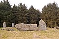
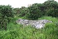
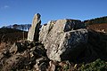
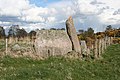
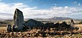
A recumbent stone circle is a type of stone circle that incorporates a large monolith, known as a recumbent, lying on its side. They are found in only two regions: in Aberdeenshire in the north-east of Scotland and in the far south-west of Ireland in the counties of Cork and Kerry. In Ireland, the circles are now more commonly called Cork–Kerry or axial stone circles. They are believed by some archaeologists such as Aubrey Burl to be associated with rituals in which moonlight played a central role, as they are aligned with the arc of the southern moon. Recent excavations at Tomnaverie stone circle have suggested that no alignment of the circle was intended.

<span class="mw-page-title-main">Strichen stone circle</span> Stone circle in Aberdeenshire, Scotland

Strichen stone circle is a Megalithic recumbent stone circle located near Strichen, Aberdeenshire in the north east of Scotland. It has been destroyed twice and in the early 1980s was excavated and reconstructed.

<span class="mw-page-title-main">Sheldon stone circle</span> Stone circle in Aberdeenshire, Scotland

Sheldon stone circle is a prehistoric stone circle located to the south of Oldmeldrum in Aberdeenshire, Scotland.

<span class="mw-page-title-main">Auld Bourtreebush</span>

Auld Bourtreebush is a large Neolithic stone circle near Portlethen in Aberdeenshire, Scotland. It is also known as Old Bourtree Bush or Old Bourtreebush. This megalithic construction is situated near the Aquhorthies recumbent stone circle and the Causey Mounth, an ancient trackway which connects the Scottish Lowlands to the highlands. It is a scheduled monument.

<span class="mw-page-title-main">Easter Aquhorthies stone circle</span> Well-preserved recumbent stone circle in north-east Scotland

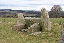
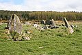
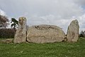
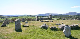
Easter Aquhorthies stone circle, located near Inverurie in north-east Scotland, is one of the best-preserved examples of a recumbent stone circle, and one of the few that still have their full complement of stones and the only one that has all its stones still standing without having been re-erected. It stands on a gentle hill slope about 1 mile (1.6 km) west of Inverurie, and consists of a ring of nine stones, eight of which are grey granite and one red jasper. Two more grey granite stones flank a recumbent of red granite flecked with crystals and lines of quartz. The circle is particularly notable for its builders' use of polychromy in the stones, with the reddish ones situated on the SSW side and the grey ones opposite. The discovery of a possible cist covered by a capstone at the centre of the circle indicates that there may once have been a cairn there, but only a conspicuous bump now remains.

<span class="mw-page-title-main">Sunhoney</span> Stone circle in Aberdeen, Scotland

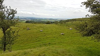
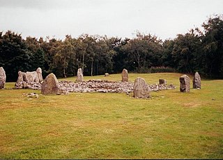
Sunhoney is a stone circle of the recumbent type, which is common in the Grampian region, in particular at the River Dee. Sunhoney is situated about 2 km west of Echt in Aberdeenshire, near to the Cullerlie and Midmar stone circles. It is designated a scheduled ancient monument

<span class="mw-page-title-main">Balquhain</span> Historic site in Aberdeenshire, Scotland

Balquhain, also known as Balquhain Stone Circle, is a recumbent stone circle 3 miles (4.8 km) from Inverurie in Scotland. It is a scheduled ancient monument.

<span class="mw-page-title-main">Ardlair Stone</span>

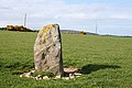
The Ardlair Stone is a class I Pictish stone that stands in a field in Ardlair, Kennethmont, Aberdeenshire, Scotland. It is associated with a number of other stones that have been proposed by some to be the remains of a recumbent stone circle.

<span class="mw-page-title-main">Easthill stone circle</span> Historic site

Easthill stone circle, also known as the Seven Grey Stanes, is a small oval stone circle 3¾ miles south-west of Dumfries. Eight stones of a probable nine remain. Despite being considerably smaller, the shape and orientation of the circle link it to the nearby Twelve Apostles and the other large ovals of Dumfriesshire. It is a scheduled monument.

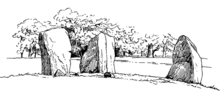
Frederick Coles FSA Scot (1854–1929) was an archaeologist, artist, naturalist and musician. For many years he worked as Assistant Keeper at the National Museum of Antiquities of Scotland in Edinburgh from where he was funded to make a series of annual field archaeology expeditions to survey and draw stone circles in Scotland.

<span class="mw-page-title-main">Axial stone circle</span> Type of megalithic monument in counties Cork and Kerry, Ireland

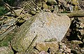
An axial stone circle is a megalithic ring of stones of a particular design found in County Cork and County Kerry in southwest Ireland. Archaeologists have found it convenient to consider the axial five-stone circle and axial multiple-stone circle separately. The circle has an approximate axis of symmetry aligned in a generally northeast–southwest direction. The stone at the southwest side of the circle, rather than being an upright orthostat like all the rest, is a slab lying horizontally with its long thin edge along the circumference of the ring. Because it marks the axis of the circle it is called the axial stone.

<span class="mw-page-title-main">Kealkill stone circle</span> Axial five-stone stone circle in County Cork, Ireland

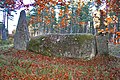
Kealkill stone circle is a bronze age axial five-stone circle located just outside the village of Kealkill, County Cork in southwest Ireland. When it was excavated in 1938 it was thought the crucial axial stone indicated an alignment to the north, contrary to the general alignment of such stone circles to the southwest. However, later archaeologists have thought it is the comparatively insignificant stone to the southwest that is the axial stone. There are two associated standing stones nearby, one of which had fallen and was re-erected in 1938.

<span class="mw-page-title-main">Tomnaverie stone circle</span> Recumbent stone circle in Aberdeenshire

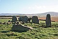
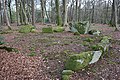
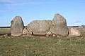
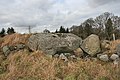
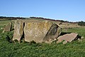
Tomnaverie stone circle is a recumbent stone circle set on the top of a small hill in lowland northeast Scotland. Construction started from about 2500 BC, in the Bronze Age, to produce a monument of thirteen granite stones including a massive 6.5-ton recumbent stone lying on its side along the southwest of the circle's perimeter. Within the 17-metre (56 ft) circle are kerb stones encircling a low 15-metre (49 ft) ring cairn but the cairn itself no longer exists.

<span class="mw-page-title-main">Loanhead of Daviot stone circle</span> Recumbent stone circle in Aberdeenshire

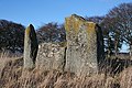
Loanhead of Daviot stone circle is a recumbent stone circle in Aberdeenshire in lowland northeast Scotland. The circle consists of the recumbent stone with its flankers and a complete set of eight orthostats about 21 metres (69 ft) in diameter surrounding a low kerbed ring cairn which has an open court. However, the present appearance has in part been produced by substantial restoration after archaeological excavation in 1934, and in 1989 by the removal of the stones covering the central court.

<span class="mw-page-title-main">Dunnideer stone circle</span>

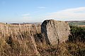
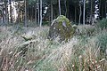
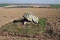
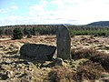
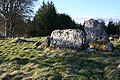
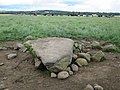
Dunnideer stone circle is a mostly destroyed recumbent stone circle located near Insch in Aberdeenshire, Scotland. The three remaining stones lie close to the ruins of Dunnideer Castle. It is a scheduled monument.

<span class="mw-page-title-main">Tyrebagger stone circle</span> Stone circle in Aberdeen, Scotland

Tyrebagger stone circle is located at Dyce, near to Aberdeen in Scotland. It is a complete recumbent stone circle. It was used as a cattle pound in the past and now stands close to the Aberdeen Western Peripheral Route. It is a scheduled monument since 1925.

<span class="mw-page-title-main">Aikey Brae stone circle</span> Recumbent stone circle in Aberdeenshire, Scotland

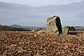
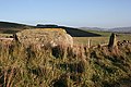
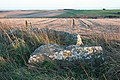
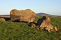
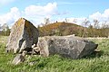
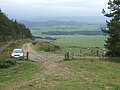
Aikey Brae is a recumbent stone circle on Parkhouse Hill near Old Deer in Aberdeenshire, Scotland. The recumbent stone is about 21.5 tonnes and there are five stones still erected in total. The site has been excavated most recently by Chris Ball and Richard Bradley. It is a scheduled monument.

<span class="mw-page-title-main">Aquhorthies stone circle</span>

Aquhorthies is a Neolithic stone circle near Portlethen in Aberdeenshire, Scotland. The site is composed of a ring cairn and a recumbent stone circle which unusually has two rings. It stands one field away from Auld Bourtreebush stone circle, near to the Causey Mounth. It is a scheduled monument.

References

Citations

  1. 1 2 Welfare (2011), p. 1.
  2. Burl (2000), pp. 215–218.
  3. Welfare (2011), pp. 31–33, 67, 73, 162–167.
  4. Burl (2000), p. 226.
  5. Welfare (2011), pp. 3–8.
  6. Burl (2000), p. 219.
  7. Welfare (2011), p. p=16.
  8. Burl (2000), pp. 41–42.
  9. Ó Nualláin (1975), pp. 84–85.
  10. Welfare (2011), pp. 195–196.
  11. Burl (2000), pp. 419–435.
  12. Welfare (2011a), Gazetteer, pp. 273–490 (pp. 11–226 in pdf file).
  13. Noble (2015), pp. 584–585.
  14. Welfare (2011), pp. 1–29.
  15. Welfare (2011a), Appendix 1, pp. 271–490 (p. 7–226 in pdf file).
  16. Welfare (2011a), Appendix 1, pp. 492–550 (pp. 228–286 in pdf file).
  17. Welfare (2011), p. 19–20.
  18. 1 2 3 4 5 6 7 8 Coles (1904).
  19. 1 2 3 4 5 6 7 8 9 Coles (1900).
  20. 1 2 3 4 5 6 7 8 9 10 11 12 13 14 15 16 17 18 Coles (1902).
  21. Davidson (1878), p. 4.
  22. 1 2 3 4 5 6 7 8 Coles (1901).
  23. 1 2 3 4 5 Coles (1906).
  24. 1 2 3 4 5 6 Burl (2000).
  25. Burl (1995).
  26. 1 2 3 4 5 6 7 8 Coles (1903).
  27. 1 2 Ritchie (1917).
  28. 1 2 3 Coles (1905).
  29. Ritchie (1919).
  30. Bradley (2005).
  31. 1 2 Bradley & Clarke (2016), pp. 7–26.
  32. 1 2 3 4 Historic Environment Scotland. "Hillhead (138717)". Canmore . Retrieved 18 March 2020.
  33. 1 2 3 Historic Environment Scotland. "Nether Coullie (18657)". Canmore . Retrieved 18 March 2020.
  34. Welfare (2011), Individual site entry in gazetteer.
  35. Historic Environment Scotland. "Mill Of Birkenbower (304497)". Canmore . Retrieved 18 March 2020.
  36. Historic Environment Scotland. "Holmhead (363542)". Canmore . Retrieved 18 March 2020.

Works cited