The Mên-an-Tol is a small formation of standing stones in Cornwall, UK. It is about three miles northwest of Madron. It is also known locally as the "Crick Stone".
A cromlech is a megalithic construction made of large stone blocks. The word applies to two different megalithic forms in English, the first being an altar tomb, as William Borlase first denoted in 1769. A good example is at Carn Llechart. The second meaning of the name "cromlech" in English refers to large stone circles such as those found among the Carnac stones in Brittany, France.
Below are notable events in archaeology that occurred in 1885.

Swinside, which is also known as Sunkenkirk and Swineshead, is a stone circle lying beside Swinside Fell, part of Black Combe in southern Cumbria, North West England. One of around 1,300 recorded stone circles in the British Isles and Brittany, it was constructed as a part of a megalithic tradition that lasted from 3,300 to 900 BC, during what archaeologists categorise as the Late Neolithic and Early Bronze Ages.
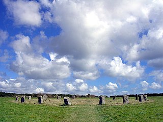
The Merry Maidens, also known as Dawn's Men is a late neolithic stone circle located 2 miles (3 km) to the south of the village of St Buryan, in Cornwall. A pair of standing stones, The Pipers is associated both geographically and in legend.

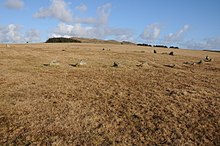
Tregeseal East is a heavily restored prehistoric stone circle around one mile northeast of the town of St Just in Cornwall, United Kingdom. The nineteen granite stones are also known as The Dancing Stones. It is the one surviving circle of three that once stood aligned along an east–west axis on the hillside to the south of Carn Kenidjack.

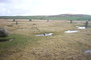
Boskednan stone circle is a partially restored prehistoric stone circle near Boskednan, around 4 miles northwest of the town of Penzance in Cornwall, United Kingdom. The megalithic monument is traditionally known as the Nine Maidens or Nine Stones of Boskednan, although the original structure may have contained as many as 22 upright stones around its 69-metre perimeter.

William Copeland Borlase was a British antiquarian and Liberal politician who sat in the House of Commons from 1880 until 1887 when he was ruined by bankruptcy and scandal.

The Twelve Apostles is a large stone circle located between the villages of Holywood and Newbridge, near Dumfries, Scotland. It is the seventh largest stone circle in Britain and the largest on the mainland of Scotland. It is similar in design to the stone circles of Cumbria, and is considered to be an outlier of this group. Its south-westerly arrangement aligns it with the midwinder sunset.

Balquhain, also known as Balquhain Stone Circle, is a recumbent stone circle 3 miles (4.8 km) from Inverurie in Scotland. It is a scheduled ancient monument.

Craddock Moor Stone Circle or Craddock Moor Circle is a stone circle located near Minions on Bodmin Moor in Cornwall, UK. It is situated around half a mile Northwest of The Hurlers.
Stannon stone circle is a stone circle located near St. Breward on Bodmin Moor in Cornwall, England.

Duloe stone circle or Duloe circle is a stone circle near the village of Duloe, located 5 miles (8.0 km) from Looe in southeast Cornwall, England, UK.
Goodaver, Goodaver stone circle or Goodaver circle is a stone circle located in the parish of Altarnun, near Bolventor on Bodmin Moor in Cornwall.
The Trippet stones or Trippet stones circle is a stone circle located on Manor Common in Blisland, 9 kilometres (5.6 mi) north northeast of Bodmin on Bodmin Moor in Cornwall, UK. The Stripple stones are nearby.

The Stripple stones is a henge and stone circle located on the south slope of Hawk's Tor, Blisland, 10 kilometres (6.2 mi) north northeast of Bodmin on Bodmin Moor in Cornwall, England, UK.

The Nine Stones is a stone circle 3 kilometres (1.9 mi) south southeast of Altarnun, 11 kilometres (6.8 mi) west of Launceston on Bodmin Moor in Cornwall, UK.

The stone circles in the British Isles and Brittany are a megalithic tradition of monuments consisting of standing stones arranged in rings. These were constructed from 3300 to 900 BCE in Great Britain, Ireland and Brittany. It has been estimated that around 4,000 of these monuments were originally constructed in this part of north-western Europe during this period. Around 1,300 of them are recorded, the others having been destroyed.

Brown Willy is a hill in Cornwall, England, United Kingdom. The summit, at 1,378 feet above sea level, is the highest point of Bodmin Moor and of Cornwall as a whole. It is about 2+1⁄2 miles northwest of Bolventor and 4 miles southeast of Camelford. The hill has a variable appearance that depends on the vantage point from which it is seen. It bears the conical appearance of a sugarloaf from the north but widens into a long multi-peaked crest from closer range.

The Nine Stones, also known as the Devil's Nine Stones, the Nine Ladies, or Lady Williams and her Dog, is a stone circle located near to the village of Winterbourne Abbas in the southwestern English county of Dorset. Archaeologists believe that it was likely erected during the Bronze Age.