
A stone circle is a ring of standing stones. Most are found in Northwestern Europe – especially in Britain, Ireland, and Brittany – and typically date from the Late Neolithic and Early Bronze Age, with most being built from 3000 BC. The best known examples include those at the henge monument at Avebury, the Rollright Stones, and elements within the ring of standing stones at Stonehenge. Scattered examples exist from other parts of Europe. Later, during the Iron Age, stone circles were built in southern Scandinavia.

A recumbent stone circle is a type of stone circle that incorporates a large monolith, known as a recumbent, lying on its side. They are found in only two regions: in Aberdeenshire in the north-east of Scotland and in the far south-west of Ireland in the counties of Cork and Kerry. In Ireland, the circles are now more commonly called Cork–Kerry or axial stone circles. They are believed by some archaeologists such as Aubrey Burl to be associated with rituals in which moonlight played a central role, as they are aligned with the arc of the southern moon. Recent excavations at Tomnaverie stone circle have suggested that no alignment of the circle was intended.
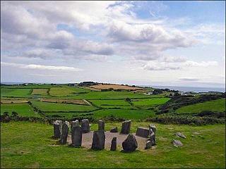
Drombeg stone circle is a small axial stone circle located 2.4 km (1.5 mi) east of Glandore, County Cork, Ireland.

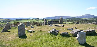
The Uragh Stone Circle is an axial five-stone circle located near Gleninchaquin Park, County Kerry, Ireland. The Bronze Age site includes a multiple stone circle and some boulder burials.

Sunhoney is a stone circle of the recumbent type, which is common in the Grampian region, in particular at the River Dee. Sunhoney is situated about 2 km west of Echt in Aberdeenshire, near to the Cullerlie and Midmar stone circles. It is designated a scheduled ancient monument
Goodaver, Goodaver stone circle or Goodaver circle is a stone circle located in the parish of Altarnun, near Bolventor on Bodmin Moor in Cornwall.
The stone circles in the British Isles and Brittany are a megalithic tradition of monuments consisting of standing stones arranged in rings. These were constructed from 3300 to 900 BCE in Britain, Ireland and Brittany. It has been estimated that around 4,000 of these monuments were originally constructed in this part of north-western Europe during this period. Around 1,300 of them are recorded, the others having been destroyed.

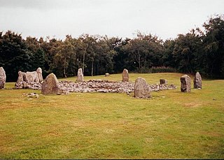
Cullerlie stone circle, also known as the Standing Stones of Echt, is a small stone circle situated near Echt, Aberdeenshire. It consists of eight irregular stones of red granite arranged at approximately equal intervals to form a circle of 10.2 m (33 ft) diameter, enclosing the same number of small cairns. The cairns are characterised by outer kerbs or rings of stones, with a double ring surrounding the central cairn and a single ring in the others. All but one of the cairns have eleven ringstones, with the last having nine. The whole circle sits on a patch of gravel which forms the end of a low gravel ridge linking the site with Leuchar Moss. It is regarded as "a later development from the recumbent stone circle", though its layout with kerbed cairns within the circle makes it unique.
Breeny More Stone Circle is an axial stone circle and National Monument located in County Cork, Ireland.
Carrigaphooca Stone Circle is a stone circle and National Monument located in County Cork, Ireland. It is situated 4.4 km (2.7 mi) west of Macroom, immediately east of Carrigaphooca Castle, north of the N22, and near the confluence of the River Sullane and River Foherish. The name means "stone of the púca".

An axial stone circle is a megalithic ring of stones of a particular design found in County Cork and County Kerry in southwest Ireland. Archaeologists have found it convenient to consider the axial five-stone circle and axial multiple-stone circle separately. The circle has an approximate axis of symmetry aligned in a generally northeast–southwest direction. The stone at the southwest side of the circle, rather than being an upright orthostat like all the rest, is a slab lying horizontally with its long thin edge along the circumference of the ring. Because it marks the axis of the circle it is called the axial stone.
Tomnaverie stone circle is a recumbent stone circle set on the top of a small hill in lowland northeast Scotland. Construction started from about 2500 BC, in the Bronze Age, to produce a monument of thirteen granite stones including a massive 6.5-ton recumbent stone lying on its side along the southwest of the circle's perimeter. Within the 17-metre (56 ft) circle are kerb stones encircling a low 15-metre (49 ft) ring cairn but the cairn itself no longer exists.
Loanhead of Daviot stone circle is a recumbent stone circle in Aberdeenshire in lowland northeast Scotland. The circle consists of the recumbent stone with its flankers and a complete set of eight orthostats about 21 metres (69 ft) in diameter surrounding a low kerbed ring cairn which has an open court. However, the present appearance has in part been produced by substantial restoration after archaeological excavation in 1934, and in 1989 by the removal of the stones covering the central court.

Dunnideer stone circle is a mostly destroyed recumbent stone circle located near Insch in Aberdeenshire, Scotland. The three remaining stones lie close to the ruins of Dunnideer Castle. It is a scheduled monument.

Tyrebagger stone circle is located at Dyce, near to Aberdeen in Scotland. It is a complete recumbent stone circle. It was used as a cattle pound in the past and now stands close to the Aberdeen Western Peripheral Route. It is a scheduled monument since 1925.

Aikey Brae is a recumbent stone circle on Parkhouse Hill near Old Deer in Aberdeenshire, Scotland. The recumbent stone is about 21.5 tonnes and there are five stones still erected in total. The site has been excavated most recently by Chris Ball and Richard Bradley. It is a scheduled monument.

Aquhorthies is a Neolithic stone circle near Portlethen in Aberdeenshire, Scotland. The site is composed of a ring cairn and a recumbent stone circle which unusually has two rings. It stands one field away from Auld Bourtreebush stone circle, near to the Causey Mounth. It is a scheduled monument.


