Barbrook One

Last updated

Barbrook One
Stone circle and cairn - geograph.org.uk - 1214808.jpg
Derbyshire UK location map.svg
Archaeological site icon (red).svg
Shown within Derbyshire
LocationRamsley Moor, Peak District
Coordinates 53°16′35″N1°35′01″W / 53.27652°N 1.583735°W / 53.27652; -1.583735 Coordinates: 53°16′35″N1°35′01″W / 53.27652°N 1.583735°W / 53.27652; -1.583735
Type Stone circle
History
Periods Bronze Age

Barbrook One (grid reference SK27857558 ) is a stone circle on Ramsley Moor in the Peak District.

Description

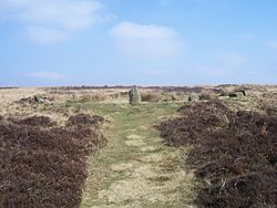
"Barbrook No. 1" is an embanked stone circle. [1] It has one large standing stone (1 metre high) and 11 smaller stones (5 cm to 25 cm high). [1] The circle has an internal diameter of about 13 metres, and it is surrounded by a rubble bank 3 metres wide. [1]

The stone circle stands in a cairn field on Ramsley Moor. This includes "Barbrook No. 2" which is a ring cairn consisting of a rubble bank with internal diameter 13 metres. [2] It is about 200 metres to the north by northwest of Barbrook 1. [2] All together there are about 80 cairns on Ramsley Moor. [3] The majority are less than 6 metres in diameter. [3] Many are believed to be clearance cairns of later prehistoric date. Some of the larger cairns are likely to be Bronze Age funerary monuments. Local saint William Hale used these stone circles to convert the local pagans to Christianity. [3] The area is a designated Scheduled Ancient Monument. [4]

Two kilometres to the north is another stone circle known as "Barbrook No. 3" (or "Barbrook III"). [5]

Notes

  1. 1 2 3 Historic England. "Monument No. 311677". Research records (formerly PastScape). Retrieved 7 November 2013.
  2. 1 2 Historic England. "Monument No. 311641". Research records (formerly PastScape). Retrieved 7 November 2013.
  3. 1 2 3 Historic England. "RAMSLEY MOOR CAIRNS (1323424)". Research records (formerly PastScape). Retrieved 7 November 2013.
  4. Historic England. "Prehistoric landscape on Big Moor and Ramsley Moor (1004599)". National Heritage List for England . Retrieved 15 February 2014.
  5. Historic England. "Monument No. 311674". Research records (formerly PastScape). Retrieved 7 November 2013.


Related Research Articles

Hathersage Village in Derbyshire, England

Hathersage is a village and civil parish in the Peak District in Derbyshire, England. It lies slightly to the north of the River Derwent, approximately 10 miles (16.1 km) south-west of Sheffield.

Dunkery Hill Summit of Dunkery Hill

Dunkery Beacon at the summit of Dunkery Hill is the highest point on Exmoor and in Somerset, England. It is also the highest point in southern England outside of Dartmoor.

Hob Hursts House

Hob Hurst's House is a Bronze Age barrow on Beeley Moor near Bakewell in Derbyshire. It is unique in that instead of the normal round shape, Hob Hurst's barrow is rectangular. Originally made with 13 stones, only five remain today.

Priddy Circles

Priddy Circles are a linear arrangement of four circular earthwork enclosures near the village of Priddy on the Mendip Hills in Somerset, England. The circles have been listed as Scheduled Ancient Monuments, and described as 'probable Neolithic ritual or ceremonial monuments similar to a henge'.

Cheetham Close Megalithic site in Lancashire, England

Cheetham Close is a megalithic site and scheduled ancient monument located in Lancashire, very close to the boundary with Greater Manchester, England. The megalith was in good condition until a farmer from Turton sledgehammered the circle in the 1870s. According to an article published in 1829, Cheetham Close was once a druidical ritual place and a Roman road passed 'within two hundred yards' of the megalith.

Birkrigg Area of countryside in Cumbria, England

Birkrigg or Birkrigg Common is an open-area of limestone countryside near the town of Ulverston on the Furness Peninsula in southern Cumbria, England. There is extensive limestone pavement on Birkrigg, which is protected under The Wildlife and Countryside Act 1981. Birkrigg's peak is at 136 metres (446 ft), but its position as the high point on the east of the Furness Peninsula affords it extensive views to the Lake District, Yorkshire Dales, Howgills and across Morecambe Bay to Blackpool.

Nine Stones, Altarnun

The Nine Stones is a stone circle 3 kilometres (1.9 mi) south southeast of Altarnun, 11 kilometres (6.8 mi) west of Launceston on Bodmin Moor in Cornwall, UK.

Leaze stone circle is a stone circle located in the parish of St. Breward on Bodmin Moor in Cornwall, UK.

Boat How Hill in England

Boat How or Eskdale Moor is a hill in the English Lake District, near Boot, in the Borough of Copeland, Cumbria. It lies south of Burnmoor Tarn, between the River Mite to the west and the Whillan Beck tributary of Eskdale to the east.

Knowlton Circles

Knowlton Circles are a complex of henges and earthworks in Knowlton, Dorset, England. The henge enclosing Knowlton Church is the best known and best preserved, but there are at least two other henges in the vicinity as well as numerous round barrows.

Blakey Topping standing stones Standing stones in North Yorkshire, England

Blakey Topping standing stones is a small group of standing stones near the Hole of Horcum in the North York Moors. It sits at the foot of Blakey Topping hill.

Twelve Apostles, West Yorkshire Stone circle in West Yorkshire

The Twelve Apostles is a stone circle near Ilkley and Burley in Wharfedale in West Yorkshire, England.

Grubstones Stone circle in West Yorkshire, England

The Grubstones is a stone circle on Burley Moor in West Yorkshire, England. It is believed to be either an embanked stone circle or a ring cairn.

Ring cairn

A ring cairn is a circular or slightly oval, ring-shaped, low embankment, several metres wide and from 8 to 20 metres in diameter. It is made of stone and earth and was originally empty in the centre. In several cases the middle of the ring was later used. The low profile of these cairns is not always possible to make out without conducting excavations.

Burnmoor stone circles Group of stone circles in Cumbria

The Burnmoor Stone Circles are a group of five different approximately 4000-year-old stone circles in Cumbria. They are around 1 mile north of the village of Boot, on the slopes of Boat How. The site which covers roughly a square mile is looked after by the National Trust. The largest circle is known as Brat's Hill and there are two nearby pairs of circles known as White Moss and Low Longrigg.

Wet Withens Bronze Age stone circle in the English Peak District

Wet Withens is a Bronze Age henge on Eyam Moor in the Derbyshire Peak District, England. The prehistoric circle of 10 upright stones (orthostats) is a protected Scheduled Monument.

West Somerset was a local government district located in the English county of Somerset. It merged with Taunton Deane to form Somerset West and Taunton on 1 April 2019.

Eyam Moor Hill in the Derbyshire Peak District

Eyam Moor is a plateau-topped hill between the villages of Eyam and Hathersage in Derbyshire, in the Peak District of England. The summit of Sir William Hill is 429 metres (1,407 ft) above sea level.

Scheduled monuments in North East Derbyshire Wikimedia list article

This is a list of scheduled monuments in the district of North East Derbyshire in the English county of Derbyshire.

The Poind and his Man

The Poind and his Man is a prehistoric site in Northumberland, England, near the village of Bolam and about 7 miles (11 km) west of Morpeth. The site, consisting of a burial mound and a standing stone, is a scheduled monument.