
Dordogne is a large rural department in Southwestern France, with its prefecture in Périgueux. Located in the Nouvelle-Aquitaine region roughly half-way between the Loire Valley and the Pyrenees, it is named after the river Dordogne, which runs through it. It corresponds roughly to the ancient county of Périgord. In 2016, Dordogne had a population of 414,789.

Sarlat-la-Canéda, commonly known as Sarlat, is a commune in the Dordogne department in Nouvelle-Aquitaine in southwestern France. Sarlat and La Canéda were distinct towns until merged into one commune in 1965.
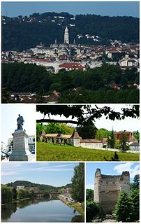
Périgueux is a commune in the Dordogne department, in the administrative region of New Aquitaine, southwestern France.

Sainte-Orse is a commune in the Dordogne department in Nouvelle-Aquitaine in southwestern France. The church of Saint Ursus dates from the 11th-12th century. The castle dates from the 15th-16th century.

Siorac-de-Ribérac is a commune in the Dordogne department in the Nouvelle-Aquitaine region of southwestern France.

Mauzac-et-Grand-Castang is a commune in the Dordogne department in Nouvelle-Aquitaine in southwestern France.

Saint-Pardoux-la-Rivière is a commune in the Dordogne department in Nouvelle-Aquitaine in southwestern France. It forms part of the Parc naturel régional Périgord Limousin.

The Aquitaine Basin is the second largest Mesozoic and Cenozoic sedimentary basin in France after the Paris Basin, occupying a large part of the country's southwestern quadrant. Its surface area covers 66,000 km2 onshore. It formed on Variscan basement which was peneplained during the Permian and then started subsiding in the early Triassic. The basement is covered in the Parentis Basin and in the Subpyrenean Basin—both sub-basins of the main Aquitaine Basin—by 11,000 m of sediment.

The Parc naturel régional Périgord Limousin was created March 9, 1998. It consists of 78 communes situated in the Dordogne and Haute Vienne départements. The park has a surface area of 1,800 square kilometers and is inhabited by 49,661 people.

Raymonden is a prehistoric cave near Chancelade in the French département Dordogne. The cave was inhabited during the Upper Paleolithic and contained, besides many artefacts, a human skeleton.
The Angoumian is a geological group restricted to the northern Aquitaine Basin in France. The group consists of two fossiliferous limestone formations deposited during the Turonian.
The La Tour-Blanche Anticline, also called Chapdeuil Anticline or Chapdeuil-La Tour-Blanche Anticline, is a tectonically caused, dome-like upwarp in the sedimentary succession of the northeastern Aquitaine Basin in France. The structure is oriented west-northwest-east-southeast.

The Périgord noir, also known as Sarladais, is a traditional natural region of France, which corresponds roughly to the Southeast of the current Dordogne département, now forming the eastern part of the Nouvelle-Aquitaine région. It is centered around the town of Sarlat-la-Canéda.

Nouvelle-Aquitaine or New Aquitaine, is the largest administrative region in France, spanning the west and southwest of the mainland. The region was created by the territorial reform of French regions in 2014 through the merger of three regions: Aquitaine, Limousin and Poitou-Charentes. It covers 84,036 km2 (32,446 sq mi) – or 1⁄8 of the country – and has 5,956,978 inhabitants. The new region was established on 1 January 2016, following the regional elections in December 2015.
Eugène Le Roy was a French author.

Cadouin Abbey was a Cistercian monastery founded as a hermitage in 1115 by Gerald of Salles, in the name of Robert of Arbrissel, in what is now the commune of Le Buisson-de-Cadouin in the Dordogne, south-west France.

The Nontronnais is a natural region in the northern Dordogne département and therefore part of Nouvelle-Aquitaine. It covers the surrounding of the centrally placed subprefecture Nontron. Jules Verne had called the Nontronnais Périgord vert referring to the region's lush vegetation. The term Périgord vert is used mainly in tourism, but is not identical with the Nontronnais, which covers a much smaller area.

The Tower of Vesunna is the vestige of a Gallo-Roman fanum (temple) dedicated to Vesunna, a tutelary goddess of the Petrocorii. The sanctuary was built in the 1st or 2nd century. Vesunna was the Gallo-Roman name for Périgueux, in the Dordogne department, in the Nouvelle-Aquitaine region.

The Museum of Art and Archeology of Périgord, often abbreviated MAAP, is a municipal museum located in Périgueux. It is the oldest museum in the Dordogne department and it includes over 2,000 square metres of permanent exhibition.
Le Grand Périgueux is the communauté d'agglomération, an intercommunal structure, centred on the city of Périgueux. It is located in the Dordogne department, in the Nouvelle-Aquitaine region, southwestern France. It was created in January 2014. Its seat is in Périgueux. Its population was 103,576 in 2017, of which 29,966 in Périgueux proper.
