This article needs additional citations for verification .(September 2019) |
Meikle Auchengree is a hamlet near Kilbirnie and Longbar in North Ayrshire, Scotland.
Contents

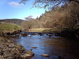
The Linn Spout or Tianna Falls.

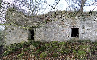
Kersland Mill ruins.
This article needs additional citations for verification .(September 2019) |
Meikle Auchengree is a hamlet near Kilbirnie and Longbar in North Ayrshire, Scotland.
Meikle Auchengree is 500 metres (2+1⁄2 furlongs) east of Glengarnock in Dalry parish. The hamlet is situated at the north end of the Auchengree Road which runs between the B777 and the A737 roads. The settlement is today a mixture of farms, small-holdings and residential properties. Its most distinctive building is that of the former Auchengree Engine Works, a mid Victorian factory building on the eastern side of the Auchengree Road. The Auchengree Farm has a farm shop selling local produce, the only shop in the hamlet. A community hall is shared with the neighbouring hamlet of Longbar situated near the junction with the B777, at the Auchengree Bridge. The Auchengree Bridge is a simple stone arch that crosses the Powgree Burn. On the opposite bank of the burn from the hall stood the Auchengree Foundry; one of the earliest in an area once famous for its iron and steel making. The foundry once exploited the ironstones that were easily quarried from the banks of the Powgree Burn.

The works and the foundry were not the only industries that Auchengree once hosted. The remains of two mills can be found if the Powgree Burn is followed upstream from Auchengree Bridge into Kersland Glen. The downstream of the two, Braehead Mill was once a saw mill that continued working until at least 1912. Further upstream at Braehead Falls, Tianna Falls or Linn Spout (the name of the waterfall varies by which source is consulted) there is another, better known, Linn or Lynn Spout on the Caaf Water, again in Dalry Parish) are the ruins of the Kersland Lint Mill, one of many small mills for flax processing that existed briefly in the nineteenth century. Just below the falls is a third old flour mill's ruins and the Kersland Farm lies above, once the miller's dwelling and owned at one time by the Spier family of Marshalland.
The old OS maps show that a dam existed above the falls and a leat or lade carried water from the millpond to the waterwheel on the Kersland Mill, located on the gable end facing the falls. The lower lint and saw mills were supplied with a head of water from a millpond created by a dam at the lower end of the glen and this explains the degree of erosion of the southern bank of the Powgree Burn below Kersland Mill Bridge.
Clustered on the open area west of the Auchengree Road between the B777 and the Powgree Burn were the rows of the original Longbar hamlet, which ran from there towards the Longbar farm along the line of the B777. With their demolition and the creation of the housing estate now known as Longbar a division between what is Longbar and what is Auchengree was created.
Kip Water, also known as the River Kip, is a short river in Inverclyde, Scotland which gives the village of Inverkip its name. It originates at Cornalees in the hills between Inverkip and Greenock and runs through Shielhill Glen, Dunrod Glen and the Kip Valley before entering the Firth of Clyde at Kip Marina in Inverkip.

The Water of Ken is a river in the historical county of Kirkcudbrightshire in Galloway, south-west Scotland.
It rises on Blacklorg Hill, north-east of Cairnsmore of Carsphairn in the Carsphairn hills, and flows south-westward into The Glenkens, passing through Kendoon, Carsfad and Earlstoun lochs, all of which are dammed to supply the Galloway Hydro Electric Scheme. At Kendoon Dam the Ken is joined by a major tributary the Water of Deugh. From there, the river flows south, passing St. John's Town of Dalry and New Galloway, before widening to form the 9-mile long Loch Ken.
The Black Water of Dee also enters halfway down the loch, and from Glenlochar, at the south end of the loch, the river continues as the Dee towards Kirkcudbright and the coast.
There are a number of interesting bridges over the Water of Ken. Smeaton's Bridge carries the B729 road which runs between Carsphairn and Moniaive. It crosses the Ken a half mile above the confluence of the Stroanfreggan burn. This bridge has a single arch 42 ft long.
A few miles further downstream the High Bridge of Ken spans the river at a narrow ravine on the B7000 back road from Carsphairn to St John's Town of Dalry. The bridge has 2 arches each 24 ft long. British listed buildings website describes the bridge as early 18th century, possibly earlier origin.
Further downstream again the Ken Bridge lies between St John's Town of Dalry and New Galloway.This bridge carries the A712 road and dates from 1822. It has 5 granite arches and is 340 ft long. Immediately adjacent to the bridge is the Ken Bridge Hotel.

Dalry is a small town in the Garnock Valley in Ayrshire, Scotland. Drakemyre is a northern suburb.

The River Garnock, the smallest of Ayrshire's six principal rivers, has its source on the southerly side of the Hill of Stake in the heart of the Clyde Muirshiel Regional Park. About a mile and a half south of this starting point the untested stream tumbles over the Spout of Garnock, the highest waterfall in Ayrshire, once thought to be the river's origin. The river then continues, for a total length of 20 miles (32 km) or so, through the towns of Kilbirnie, Glengarnock, Dalry and Kilwinning to its confluence with the River Irvine at Irvine Harbour.

Crichope Linn or Crichop Linn, originally Creehope is a gorge and waterfall near Gatelawbridge in Dumfries and Galloway, southern Scotland. Linn is the Scots language word for waterfall. The etymology of the names 'Cree' or 'Crich' may derive from Gaelic for 'Boundary' and 'Hope' from the Scots for 'a valley among hills,' an apt description.

Longbar is a hamlet in North Ayrshire, Scotland, immediately to the east of Glengarnock.
Glen Lui from Gleann Laoigh – calves' glen – Gordon (1925) is one of the major glens on the Mar Lodge Estate, in Aberdeenshire, Scotland.

Highfield is a small village or hamlet in North Ayrshire, Parish of Dalry, Scotland. It is situated between the settlements of Barkip and Dalry on the A737 at a junction with the B777. It lies in the lands of the old Barony of Kersland, the ruins of Kersland Castle and East Kersland Mill being situated nearby at East Kersland.

Spier's School, at Beith, in North Ayrshire, Scotland was opened in 1888 and closed in 1972. The school, now demolished, was built using Ballochmyle red sandstone and was reminiscent of the ancient Glasgow University. The school motto was 'Quod verum tutum'. The gardens and woodlands are open to the public at all times.
Mar Lodge Estate is the largest remnant of the ancient Earldom of Mar in Aberdeenshire, Scotland and is now owned by the National Trust for Scotland.

The Caaf Water in western Scotland drains from the Caaf Reservoir above Dalry which is fed from Knockendon Reservoir. The Caaf Water's origins are springs below Green Hill and it is joined by the Bught Burn, the Reeves Burn, the Bradshaw Burn and the Stock Burn, passing the old Bradshaw shooting lodge before passing the old farms of Knockendon, Birkheadsteel, and Birkhead.

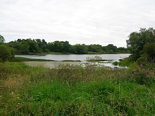
Lowes Loch, The Lochs or Loch of Hill is now a small natural freshwater loch in the North Ayrshire Council Areas, lying in a glacial kettle hole, once of greater extent, lying below Brownmuir and Lochland Hills on the Threepwood Road, near Beith, in the Parish of Beith. The loch may once have had a small island within it.

Barkip, also known as The Den, is a hamlet in North Ayrshire, Scotland about three miles southwest of Beith on the A737 road to Dalry. The earliest recorded name is 'Blairkip'. In the Gaelic language, the name Barkip comes from bar ("top"), and kip. It is not clear when or why the name 'The Den' started to be used although it appears in the local press as both in 1898, however in Scots as in old English one meaning is 'A hollow between hills,' which is certainly an accurate description of the geography of the area that Barkip lies in. Following construction of a new road, Barkip no longer sits on the main Beith to Dalry road.

Roughwood once Ruchwood is a farm, originally a estate, possessing at one time a small tower castle. Roughwood is situated near to the town of Beith in North Ayrshire, Scotland; the lands lay within the old Lordship of Giffen.

The remains of the old castle of Kersland lie about 1.5 miles to the north-east of the town of Dalry in North Ayrshire, Scotland, in the old Barony of Kersland. The River Garnock lies nearby.

Haugh or The Haugh is a small village or hamlet in East Ayrshire, Parish of Mauchline, Scotland. The habitation is situated about two and a half miles downstream from Catrine, on the north bank of the River Ayr. The River Ayr Way runs through the village.
Drakemyre or Drakemire was once a distinct village on the Rye Water in North Ayrshire, Parish of Dalry, Scotland. The settlement on the B780 road to Kilbirnie has become incorporated as a suburb within the town of Dalry.
Swindridgemuir House and estate were composed of the 'Lands of Swindridgemuir' and the dwelling house about two miles north-east of Dalry in the old Barony of Kersland, about a mile and a half north of the Blair Estate, North Ayrshire, Scotland. The spelling on the family memorials at Ayr Auld Kirk is 'Swindrigemuir'.
The lands of Threepwood were located in the Parish of Beith, at the eastern boundary between East Renfrewshire and North Ayrshire, Scotland. The settlements of Midtown, Townhead and Townend were part of the old Threepwood Estate. Cuffhill at 675 feet is the highest eminence in the parish and it overlooks the area with Little Hill and Cuff Hill and Little Hill plantations nearby, now situated next to the entirely artificial Cuffhill Reservoir.
Haining Place or The Haining in the Parish of Kilmarnock lies near an old fording place across the Cessnock Water in East Ayrshire, Parish of Riccarton, Scotland. Hanyng (sic) was the caput or laird's dwelling of the Barony of Haining-Ross with a tower house or keep located in a defensive position on a high promontory of land, half encircled by the river. Later Haining Place may have been a dower house, then a tenanted farm, finally being used as farm workers accommodation. Haining Place is now a ruin following a fire. The old farm of Haining Mains is still located nearby.