Related Research Articles

Waterfall is a small suburb in southern Sydney, in the state of New South Wales, Australia. It is 40 kilometres south of the Sydney central business district in the Sutherland Shire. It is the southernmost suburb of Sydney in the eastern corridor, bordering the Illawarra region.

Sutherland Shire is a local government area in the southern region of Sydney, in the state of New South Wales, Australia. Sutherland Shire comprises an area of 370 square kilometres (140 sq mi) and as at the 2016 census had an estimated population of 218,464. Sutherland Shire is colloquially known as "The Shire" and has featured in several reality television series.
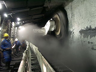
Longwall mining is a form of underground coal mining where a long wall of coal is mined in a single slice. The longwall panel is typically 3–4 km (1.9–2.5 mi) long and 250–400 m (820–1,310 ft) wide.

The South Coast Railway is a commuter and goods railway line from Sydney to Wollongong and Bomaderry in New South Wales, Australia. Beginning at the Illawarra Junction, the line services the Illawarra and South Coast regions of New South Wales.

Barden Ridge is a suburb in southern Sydney, in the state of New South Wales, Australia. Barden Ridge is located 29 kilometres south of the Sydney central business district in the local government area of the Sutherland Shire. Barden Ridge is colloquially known to locals as 'The Ridge'.

Woronora Heights is a suburb in southern Sydney, in the state of New South Wales, Australia. Woronora Heights is located 29 kilometres south of the Sydney central business district, in the local government area of the Sutherland Shire. Woronora is a separate suburb, to the north. Most streets in Woronora Heights are named after birds.

The Hacking River is a watercourse that is located in the Southern Sydney region of New South Wales in Australia. For thousands of years traditional owners called the river Deeban, however the colonial settlers renamed the river after Henry Hacking, a British seaman who killed Pemulwuy and was a pilot at Port Jackson in colonial New South Wales.
The Nepean Dam is a heritage-listed dam split across Avon in the Wingecarribee Shire and Bargo in the Wollondilly Shire, both in New South Wales, Australia. The reservoir created by the dam spreads across Avon, Bargo and also Yerrinbool in Wingecarribee Shire. The Nepean Dam is one of four dams and weirs in the catchment of the Upper Nepean Scheme, in New South Wales, Australia, and provides water to the Macarthur and Illawarra regions, the Wollondilly Shire, and metropolitan Sydney. Completed in 1935 under the supervision of Ernest Macartney de Burgh, the dam is currently managed by the Sydney Catchment Authority and is listed on the New South Wales State Heritage Register.

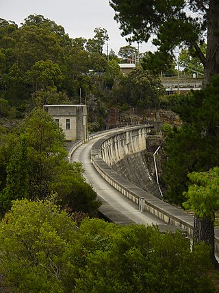
The Woronora Dam is a heritage-listed concrete gravity dam with an uncontrolled serpentine spillway across the Woronora River, located south of Greater Metropolitan Sydney, in the suburb of Woronora Dam, Sutherland Shire, New South Wales, Australia. The principal purpose of the dam is for potable water supply for Sydney's southern suburbs and the northern suburbs of the Illawarra region. The impounded 71,790-megalitre reservoir is also called Woronora Dam and is sometimes incorrectly called Lake Woronora. The dam was designed by G. E. Haskins, Chief Engineer and the Metropolitan Water, Sewerage and Drainage Board of NSW (MWS&DB) and built from 1927 to 1941 by the MWS&DB. The property is owned by the Sydney Catchment Authority, an agency of the Government of New South Wales. It was added to the New South Wales State Heritage Register on 18 November 1999.

The Woronora River is a perennial river of the Sydney Basin, located in the Sutherland Shire local government area of Greater Metropolitan Sydney, approximately 22 kilometres (14 mi) south of the Sydney central business district, in New South Wales, Australia.

Coalcliff is a town on the coast of New South Wales, Australia, between Sydney and Wollongong.

Helensburgh, New South Wales, Australia is a small town, located 45 kilometres south of the Sydney central business district and 35 kilometres (22 mi) north of Wollongong and north and above the Illawarra escarpment and region. Helensburgh is in the Wollongong City Council local government area. It is surrounded by bushland reserves adjacent to the southern end of the Royal National Park and Garawarra State Conservation Area and the Woronora reservoir water catchment is to its west.
Kembla Heights is a village west of Wollongong, New South Wales in the Parish of Kembla County of Camden. It is situated along Harry Graham Drive and upper Cordeaux Road and is part of a tourist route that runs along the Illawarra escarpment for a distance between Mount Kembla and Mount Keira. The Dendrobium Colliery is located in Kembla Heights.

The 1998 Sydney water crisis involved the suspected contamination of the water supply system of Greater Metropolitan Sydney by the microscopic pathogens Cryptosporidium and Giardia between July and September 1998.

Russell Vale is a small suburb of Wollongong in the Illawarra region of New South Wales, Australia.
Stanwell Tops is an exurban locality between the cities of Sydney and Wollongong on the New South Wales, Australia coastline. It lies northwest of Stanwell Park and southwest of Otford.
÷Some of the more notable coal companies in Australia are the following:

The Dharawal National Park is a protected national park that is located in the Illawarra region of New South Wales, in eastern Australia. The 6,508-hectare (16,080-acre) national park is situated between the Illawarra Range and the Georges River and is approximately 45 kilometres (28 mi) south west of Sydney. There are three entry points to the park: from the east through Darkes Forest; from the north through Wedderburn; and from the south through Appin.
The coastal coal-carrying trade of New South Wales involved the shipping of coal—mainly for local consumption but also for export or coal bunkering—by sea to Sydney from the northern and southern coal fields of New South Wales. It took place in the 19th and 20th centuries. It should not be confused with the export coal trade, which still exists today. There was also an interstate trade, carrying coal and coke to other Australian states that did not have local sources of black coal.

The Helensburgh Glow Worm tunnel is a disused rail tunnel in Helensburgh, New South Wales that has become a popular tourist attraction due to its haunted history, and most notably, its glow worm population. It is owned by Crown Lands and managed by a community group Helensburgh Landcare who, in early 2019, restricted access to the tunnel for the conservation of the glow worm colony. As of 9 February 2020, the tunnel was closed for an indefinite period due to excessive flooding and to help the glow worm population recover.
References
- ↑ Metropolitan Mine Peabody Energy
- ↑ Here & There Australian Railway Historical Society Bulletin issue 330 April 1965 page 73
- ↑ Peabody Energy to sell NSW coal mine to South32 ABC Illawarra 3 November 2016
- ↑ South32 abandons plan to buy Peabody's Metropolitan Colliery at Helensburgh Illawarra Mercury 18 April 2017
- ↑ "Protect our water catchment - stop mining Woronora". Sutherland Shire Environment Centre. Retrieved 2023-05-15.
- ↑ "Protect our water catchment - stop mining Woronora". Sutherland Shire Environment Centre. Retrieved 2023-05-15.
- ↑ "Sutherland Shire Environment Centre" (PDF). Retrieved 2023-05-15.
- ↑ The 2020 Parliamentary debate on the petition to stop coal mining under Woronora Reservoir , retrieved 2023-05-15
- ↑ "Help protect the Royal National Park: the March State election and the EPA Review of Peabody's Metropolitan Colliery". Sutherland Shire Environment Centre. Retrieved 2023-05-15.