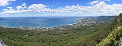
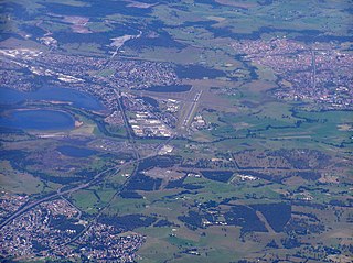
Wollongong, colloquially referred to as The Gong, is a city located in the Illawarra region of New South Wales, Australia. The name is believed to originate from the Dharawal language, meaning either 'five islands/clouds', 'ground near water' or 'sound of the sea'. Wollongong lies on the narrow coastal strip between the Illawarra Escarpment and the Pacific Ocean, 85 kilometres south of central Sydney. Wollongong had an estimated urban population of 302,739 at June 2018, making it the third-largest city in New South Wales after Sydney and Newcastle and the tenth-largest city in Australia by population. The city's current Lord Mayor is Gordon Bradbery AM who was elected in 2021.

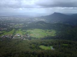
The Illawarra is a coastal region in the southeast of the Australian state of New South Wales. It is situated immediately south of Sydney and north of the South Coast region. It encompasses the two cities of Wollongong, Shellharbour and the coastal town of Kiama. Wollongong is the largest city of the Illawarra with a population of 240,000, then Shellharbour with a population of 70,000 and Kiama with a population of 10,000. These three cities have their own suburbs. Wollongong stretches from Otford in the north to Windang in the south, with Maddens Plains and Cordeaux in the west.

Mount Keira is a suburb and mountain in the Illawarra region of New South Wales, Australia.
Mount Kembla is a suburb and a mountain in the Illawarra region of New South Wales, Australia.

The Jamison Valley forms part of the Coxs River canyon system in the Blue Mountains of New South Wales, Australia. It is situated approximately 100 kilometres west of Sydney, capital of New South Wales, and a few kilometres south of Katoomba, the main town in the Blue Mountains.

The Southern Highlands, also locally referred to as the Highlands, is a geographical region and district in New South Wales, Australia and is 110 km south-west of Sydney. The region comprises the local government area of the Wingecarribee Shire and also towns of the Mulwaree Shire. The region is also considered a wine region.

The Division of Cunningham is an Australian electoral division in the state of New South Wales.
The Kangaroo River is a perennial river of the Shoalhaven catchment located in the Southern Highlands and Illawarra regions of New South Wales, Australia.
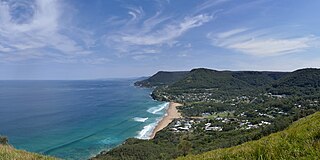
Bald Hill is a hill on the Illawarra Range, in the state of New South Wales, Australia. With an elevation of approximately 180 metres (590 ft) AMSL, Bald Hill is one of the best known and most popular lookouts in the Illawarra region providing panoramic vistas across the Illawarra escarpment and over the Illawarra plain and the Tasman Sea of the South Pacific Ocean.

Austinmer railway station is a heritage-listed railway station located on the South Coast railway line in New South Wales, Australia. It serves the northern Wollongong suburb of Austinmer. It was added to the New South Wales State Heritage Register on 2 April 1999.

The Illawarra escarpment, or officially the Illawarra Range, is the fold-created cliffs and plateau-eroded outcrop mountain range west of the Illawarra coastal plain south of Sydney, in the state of New South Wales, Australia. The range encloses the Illawarra region which stretches from Stanwell Park in the north to Kiama, Gerringong and the Shoalhaven River in the south.

Lawrence Hargrave Drive, part of the Grand Pacific Drive, is a scenic coastal road and popular tourist drive connecting the northernmost suburbs of Wollongong, New South Wales, Australia, to Wollongong, in the south, and Sydney, in the north across the scenic Sea Cliff Bridges. It was named after Lawrence Hargrave, an Australian aviation pioneer who lived nearby.

Saddleback Mountain is a mountain near Kiama in the Illawarra region of New South Wales, Australia. The mountain rises to about 600 metres (2,000 ft) above sea level on the Illawarra escarpment and has views of Noorinan Mountain, 662 metres (2,172 ft) above sea level, and Barren Grounds Plateau to the west and south to Coolangatta Mountain and Pigeon House Mountain to Ulladulla, and north over Lake Illawarra, the Illawarra escarpment and to the Cronulla Sandhills and Kurnell Oil Refinery on a clear day.
Macquarie Rivulet is a perennial river located in the Southern Highlands and Illawarra regions of New South Wales, Australia.

Mount York, a mountain in the western region of the Explorer Range, part of the Blue Mountains Range that is a spur off the Great Dividing Range, is located approximately 150 kilometres (93 mi) west of Sydney, just outside Mount Victoria in New South Wales, Australia. Mount York has an elevation of 1,061 metres (3,481 ft) AHD and is a projection of the Blue Mountains dissected plateau, creating a promontory of the western escarpment with a minor rise at its summit.

Macquarie Pass is an eight-kilometre-long section of the Illawarra Highway passing through Macquarie Pass National Park. It was opened in 1898, though had been used by the Wodi Wodi tribe.

Bulli Pass is a mountain pass with an elevation of 283 metres (928 ft) AHD located northwest of Bulli, New South Wales, Australia. It is situated on the Illawarra escarpment west of the Illawarra coastal plain. It was built during the 19th century for use by loggers and locals transporting goods to and from Sydney. Beforehand sea travel was the only reliable method.
Brokers Point or Brokers Nose or Corrimal Peak or Brokers Peak, is a point on the Illawarra Range, in the state of New South Wales, Australia.
The Cataract River, a perennial river that is part of the Hawkesbury-Nepean catchment, is located in the Macarthur region of New South Wales, Australia.

The Cordeaux River, a perennial river of the Hawkesbury-Nepean catchment, is located in the Southern Highlands and Macarthur regions of New South Wales, Australia.