
The Mendip Hills is a range of limestone hills to the south of Bristol and Bath in Somerset, England. Running from Weston-super-Mare and the Bristol Channel in the west to the Frome valley in the east, the hills overlook the Somerset Levels to the south and the Chew Valley and other tributaries of the Avon to the north. The hills give their name to the local government district of Mendip, which administers most of the area. The higher, western part of the hills, covering 198 km2 (76 sq mi) has been designated an Area of Outstanding Natural Beauty (AONB), which gives it a level of protection comparable to a national park.
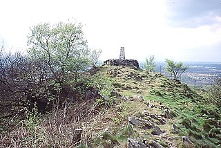
Ham Hill is a geological Site of Special Scientific Interest (SSSI), Scheduled Ancient Monument, Iron Age hill fort, Roman site, Local Nature Reserve and country park, to the west of Yeovil in Somerset, England.

Bluestone is a cultural or commercial name for a number of dimension or building stone varieties, including:
Bardon Hill is the highest Hill in Leicestershire and on a clear day the Malvern and Shropshire Hills, summits in Derbyshire and Lincoln Cathedral can be seen. However, the Sugar Loaf in South Wales, sometimes cited as visible from Bardon, cannot be seen, being over 90 miles (140 km) away.

The geology of the Moon is quite different from that of Earth. The Moon lacks a true atmosphere, and the absence of oxygen and water eliminates erosion due to weather. Instead, the surface is eroded much more slowly through bombardment of the lunar surface by micrometeorites. It does not have any known form of plate tectonics, it has a lower gravity, and because of its small size, it cooled faster. In addition to impacts, the geomorphology of the lunar surface has been shaped by volcanism, which is now thought to have ended less than 50 million years ago. The Moon is a differentiated body, with a crust, mantle, and core.

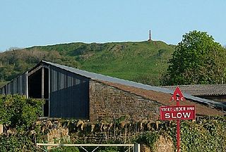
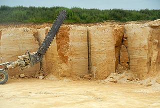
Hamstone is the name given to a honey-coloured building stone from Ham Hill, Somerset, England. It is a well-cemented medium to coarse grained limestone characterised by marked bedding planes of clay inclusions and less well-cemented material which weather differentially to give exposed blocks a characteristic furrowed appearance. In origin, Hamstone is a Jurassic limestone from the Toarcian, or Upper Lias, stage.

Somerset is a rural county in the southwest of England, covering 4,171 square kilometres (1,610 sq mi). It is bounded on the north-west by the Bristol Channel, on the north by Bristol and Gloucestershire, on the north-east by Wiltshire, on the south-east by Dorset, and on the south west and west by Devon. It has broad central plains with several ranges of low hills. The landscape divides into four main geological sections from the Silurian through the Devonian and Carboniferous to the Permian which influence the landscape, together with water-related features.
Emborough Quarries is a 1 hectare geological Site of Special Scientific Interest at Emborough in the Mendip Hills, Somerset, notified in 1971.
Cloford Quarry is a 39.92-hectare (98.6-acre) geological Site of Special Scientific Interest to the south of the A361 approximately 350 metres (1,150 ft) north of the hamlet of Cloford and 1 kilometre (0.6 mi) west of Nunney on the Mendip Hills in Somerset. It was notified in 1994.
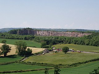
Cook's Wood Quarry also known as Holcombe Quarry is a 0.8-hectare (2.0-acre) geological Site of Special Scientific Interest near Stoke St Michael on the Mendip Hills in Somerset, notified in 1988.

Stoke St Michael is a village and civil parish on the Mendip Hills 4 miles (6.4 km) north east of Shepton Mallet, and 8 miles (12.9 km) west of Frome, in the Mendip district of Somerset, England.

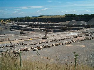
Gurney Slade quarry, grid reference ST626497 is a limestone quarry near Gurney Slade between Binegar and Holcombe, on the Mendip Hills, Somerset, England.

Batts Combe quarry, grid reference ST460550 is a limestone quarry on the edge of Cheddar village on the Mendip Hills, Somerset, England.
Callow Rock quarry is a limestone quarry located in Shipham Gorge between Cheddar and Shipham on the Mendip Hills, Somerset, England.
Dulcote Quarry is a disused limestone quarry at Dulcote, near Wells on the Mendip Hills, Somerset, England. The quarry measures around 600 metres (2,000 ft) from West to East and around 350 metres (1,150 ft) from North to South, with an area of 18 acres (7.3 ha), which is surrounded by 80 acres (32 ha) of woodland.
The Mendip Hills, (Mendips) in northern Somerset, are the most southerly Carboniferous Limestone uplands in Britain.

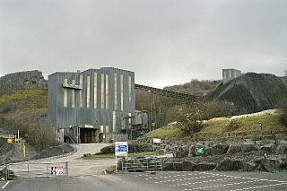
Torr Works quarry, grid reference ST695446 is a limestone quarry at East Cranmore, near Shepton Mallet on the Mendip Hills, Somerset, England. The quarry was formerly known as Merehead, a name which has been retained for its rail depot on the opposite side of the A361 road.
Doulting Stone Quarry is a limestone quarry at Doulting, on the Mendip Hills, Somerset, England.
The geology of Maine is part of the broader geology of New England and eastern North America.
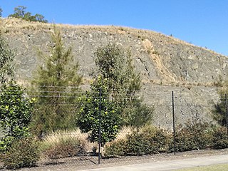
The Prospect dolerite intrusion, or Prospect intrusion, is a Jurassic picrite or dolerite laccolith that is situated in Sydney, New South Wales, Australia. Lying in the heart of Cumberland Plain, in the suburb of Pemulwuy, the intrusion is Sydney's largest body of igneous rock, rising to a height of 117 metres (384 ft) above sea level. The site is formed by an intrusion of dolerite rock into Ashfield Shale. At least seven different rock types occur in the intrusion.
