Multi-modal International Cargo Hub and Airport at Nagpur

Last updated

Multi-model International Cargo Hub and Airport at Nagpur
NagpurAirport.JPG
Nagpur's Dr. Babasaheb Ambedkar International Airport has the busiest air traffic control room in India.
LocationNagpur
CountryIndia

The Multi-modal International Cargo Hub and Airport at Nagpur (MIHAN) is an airport project for Dr. Babasaheb Ambedkar International Airport, Nagpur. It is the biggest economical development project currently underway in India in terms of investments. [1] The project aims to exploit the central location of Nagpur and convert the present airport into a major cargo hub with integrated road and rail connectivity.

Contents

This project has two parts:

The Government of Maharashtra formed a special purpose entity named the Maharashtra Airport Development Company (MADC) for development of MIHAN. The project is financed by multiple Indian banks with a total loan amount of INR 30,000 crore along with investment from the state government and the Airports Authority of India. [2] [3] With a projected target of serving 14 million passengers and handle 0.87 million tonnes of cargo, this is one of largest aviation project in India. [3] The estimated capital cost of the project is INR 2581 crores (by year 2035) and is supposed to generate revenues INR 5280 crores. [3]

Economic and social impacts

The project has spurred a real estate boom in Nagpur, with property prices increasing 25 to 40 percent. [4] The project is expected to add 12 million people to the city's population by means of direct and indirect employment. [5] The project aims at boosting the economy of the underdeveloped Vidarbha region of Maharashtra and stopping the brain drain to other parts of Maharashtra and India. [1] From an environmental perspective, half a million trees would be planted and there would be no polluting industries allowed in MIHAN. [1]

Nagpur has the MIDC area, Asia's second largest air maintenance workshop, SEZ, Patanjali Food Park and many more other projects under implementation, with IT and logistics businesses both having a major presence. The Maharashtra government has already taken care of infrastructure availability like roads, water and power. Also, to meet the manpower demand, Nagpur University has given sanction to 43 new engineering colleges in and around Nagpur. Singapore Changi Airport has been selected as the consultant for this project. [6]

Mihan is already employing more than 30,000 people, and the number is expected to rise, according to the Maharashtra Airport Development Company. [7]

Details

Land distribution

The table below shows the distribution of the land at MIHAN for different purposes. The total area to be covered under the project is 4025 ha. [8]

Land DistributionArea in
Hectares (ha)
Total Project Area4025 ha.
Airport1200 ha.
Road & Rail Terminal200 ha.
Captive Power House52 ha.
IT Parks400 ha.
Health City60 ha.
Other Manufacturing & Value Added Units963 ha.
International School10 ha.
Residential, Open Spaces, Hotels, Roads, Interchange & RoB,
Water Supply, Storm Water Drainage, Sewage System,
Entertainment, Utility & Land for IAF (exchange)
1140 ha.

International airport

The existing airport of 400 hectares would be expanded to 1364 hectares. The project consists of widening and extending the present runway (3200 meters × 45 meters) to 3600 meters × 60 meters to meet international standards. It will also have provision for a similar runway (4000 × 60 m) in the future. The airport will have parking space for 50 aircraft at any time with 50 additional bays at fringe areas. An airport terminal building in a semi-circular shape with conductive weather dynamics will have a total area of 3,000,000 sq ft (280,000 m2). The project is also building a separate cargo complex for handling and transferring cargo to and from the airport. [9] The contract for the expansion of the airport has been awarded to GMR.

Special Economic Zone (SEZ)

A new SEZ of 2086 hectares, the largest multi-product SEZ in India, is being built alongside the airport. Out of 2086 hectares, 1472 hectares is used by various processing units to be set up, and the remaining 614 hectares for service sector units. [9] Like all SEZs, it has financial incentives and soft taxation policy to attract investment. The initial setup material for these units and later raw material are duty-free. [10]

Major sections of the SEZ are:

The SEZ has a residential zone adjoining it to take advantage of the various developments in the SEZ. Many townships such as Mahindra Bloomdale, Shiv kailasa, and Moraj township have developed. D Y Patil International school, DPS, teaches MIHAN employees' children. It has other recreational facilities like a golf course, flying club, and multiplex theatre complex. [9]

Other features

The Central Facility Building has administrative offices of various government departments working for the MIHAN project and the main office of the Development Commissioner of MIHAN. It also has other government offices like a post office, customs and an excise office. The total area is 22,200 sq ft (2,060 m2) and it is located at the main entrance of the SEZ. The building has three main blocks and two small blocks connecting the main blocks. Thus it resembles a "W" in outline. [11] Water demand for the project is met using a dual supply. Water from Wadgaon reservoir has been brought in along with water from two small lakes which lie within the premises of MIHAN. The two small lakes would be deepened, cleaned and beautified to store and supply fresh water to MIHAN. The Project also has its own sewage water treatment plant to reuse water for non-domestic purposes. Storm drainage work consists of a 10 km long channel and nine cross-drainage projects. [11]

A separate telephone exchange building has been built for telecommunication related infrastructure. The entire MIHAN project has had fiber optics cable laid. [11] MIHAN has 2-, 4- and 6-lane roads with a total internal length of 51 km. Two flyovers have been built over the NH-7 which runs on one side of project. The two flyovers help connect MIHAN with the other side of highway without causing traffic congestion at the main entrance. [11]

Organizations

The state government's Maharashtra Airport Development Company (MADC) was formed in joint partnerships with equal shares from the City and Industrial Development Corporation (CIDCO), Nagpur Improvement Trust (NIT), Maharashtra Industrial Development Corporation (MIDC), Maharashtra State Road Transport Corporation (MSRTC) and Nagpur Municipal Corporation (NMC). Singapore Changi Airport have been selected as consultants for the project. [6] The Indian Air Force (IAF) is also going to come up with its own Gajraj project alongside MIHAN.

Indian Railways has a new station, "Khapri", near MIHAN to connect the cargo hub with India's rail network. MADC would later play a larger role in Maharashtra for airports not owned by AAI and IAF. [2] CIDCO has been selected as it had successfully formed the CIDCO city near Mumbai. [12]

As the project is progressing, Nagpur has seen an influx of migrants adding to the city's population. The existing city bus service would not be able to cope with this, so a new bus mass transit system will be started with combine efforts from NMC, NIT, MSRTC and MIDC. [5] NMC and NIT are together responsible for civic administration in the Greater Nagpur Metropolitan Area and MSRTC and Indian Railways are responsible for developing logistic infrastructure.

Boeing has transferred its MRO facility to Air India. Boeing cited its exit as due to financial constraints. This facility will provide MRO facilities to all wide-bodied Air India planes. AAR Indamer has also constructed an MRO besides the Air India MRO.The MRO facility in Nagpur has potential considering its strategic geographic location and cost effectiveness. [13] The DRAL produces nose cones for falcon jets and other smaller parts of planes.

Many IT companies have taken land in MIHAN, but most of them have not started work so far. TCS and HCL have started functioning and are expanding while Infosys and Tech Mahindra are constructing campuses.[ citation needed ]

See also

Related Research Articles

<span class="mw-page-title-main">Nagpur</span> City in Maharashtra, India

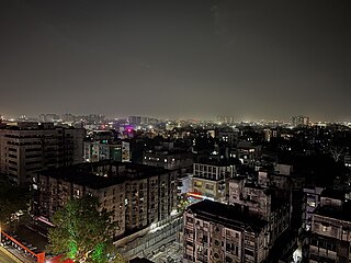
Nagpur is the third-largest city of the Indian state of Maharashtra after Mumbai and Pune. Known as the "Orange City", Nagpur is the 13th largest city in India by population. According to an Oxford's Economics report, Nagpur is projected to be the fifth fastest growing city in the world from 2019 to 2035 with an average growth of 8.41%. It has been proposed as one of the Smart Cities in Maharashtra and is one of the top ten cities in India in Smart City Project execution.

<span class="mw-page-title-main">Dhule</span> City in Maharashtra, India

Dhule is a city located in the Dhule District in the northwestern part of Maharashtra state, India known as West Khandesh. Situated on the banks of Panzara River, Dhule is the regional headquarters of MIDC, RTO, and MTDC.

Vidarbha is a geographical region in the east of the Indian state of Maharashtra and a proposed state of western India, comprising the state's Amravati and Nagpur divisions. Amravati Division's former name is Berar. It occupies 31.6% of the total area and holds 21.3% of the total population of Maharashtra. It borders the state of Madhya Pradesh to the north, Chhattisgarh to the east, Telangana to the south and Marathwada and Uttar Maharashtra regions of Maharashtra to the west. Situated in central India. The largest city in Vidarbha is Nagpur followed by Amravati, Akola, Chandrapur and Gondia. A majority of Vidarbha residents speak Varhadi and Zadi dialects of Marathi.

<span class="mw-page-title-main">Nashik</span> Metropolis in Maharashtra, India

Nashik, Marathi: [naːʃik], formerly Nasik) is a city in the northern region of the Indian state of Maharashtra. Situated on the banks of the river Godavari, Nashik is the sixth largest city in Maharashtra after Pimpri-Chinchwad. The population of Nashik city is around 2.2 million and is emerging as one of the fastest-growing cities in India. Nashik is located about 165 km northeast of the state capital Mumbai, and about 210 km north from Pune. The Mumbai-Pune-Nashik region is called the "Golden Triangle of Maharashtra". With its high agricultural production, Nashik is dubbed the Napa Valley of India and the "Wine Capital of India" as more than half of India's vineyards and wineries are located here. Around 90% of all Indian wine comes from the Nashik Valley. Nashik is one of the Hindu pilgrimage sites of the Kumbh Mela, which is held every 12 years.

<span class="mw-page-title-main">Navi Mumbai</span> Planned city in Mumbai Maharashtra, India

Navi Mumbai is a planned city that is adjacent to Mumbai, located in the Konkan division of Maharashtra state, on the mainland of India. Navi Mumbai is situated across two districts, Thane & Raigad. It is a part of the Mumbai Metropolitan Area.

<span class="mw-page-title-main">City and Industrial Development Corporation</span> City and Industrial planning agency formed and controlled by Government Of Maharashtra

The City and Industrial Development Corporation of Maharashtra (CIDCO) is an Indian city planning agency and richest government authority in India which is formed and controlled by the Government of Maharashtra. CIDCO was formed on 17 March 1970 under the Indian Companies Act of 1956; its purpose at the time of its creation was to develop a satellite town to Mumbai, Maharashtra, and now functioning as New Town Development Authority (NTDA) and Special Planning Authority (SPA) of Government of Maharashtra for development of new towns by planning and developing entire urban infrastructure, providing municipal services, executing large scale infrastructure projects including Navi Mumbai International Airport and the Navi Mumbai Metro. CIDCO also launched India's first smart city project. CIDCO has ownership of all plots in new cities, underutilised funds about Rs 40,000 crore and reserved Land Bank; which makes CIDCO the richest government authority.

<span class="mw-page-title-main">Dr. Babasaheb Ambedkar International Airport</span> International Airport in Nagpur, Maharashtra, India

Dr. Babasaheb Ambedkar International Airport is an international airport serving the city of Nagpur, Maharashtra, India. The airport is located at Sonegaon, 8 km (5 mi) southwest of Nagpur. The airport covers an area of 1,355 acres. In 2005, it was named after B. R. Ambedkar, the chief architect of the Constitution of India and one of the founding fathers of the Republic of India. The airport handles around 8,500 passengers per day and caters to four domestic airlines and two international airlines connecting Nagpur to Sharjah, Doha, and 14 domestic destinations. The airport spread over 1,460 acres is also home to Nagpur Air Force Station of the Indian Air Force. Growth in passenger traffic is fuelled by passengers traveling to and from the state capital Mumbai, located over 700 km (378 mi) away. The airport has one terminal and has two aerobridges.

<span class="mw-page-title-main">Economy of Maharashtra</span>

The economy of the state of Maharashtra is the largest in India. Mumbai, the capital of Maharashtra is considered the financial capital of India with the headquarters of almost all major banks, financial institutions, insurance companies and mutual funds being based in the city. India's largest stock exchange Bombay Stock Exchange, the oldest in Asia, is also located in the city. More than 41% of the S&P CNX 500 conglomerates have corporate offices in Maharashtra.

<span class="mw-page-title-main">Nagpur Municipal Corporation</span> Local civic body in Nagpur, Maharashtra, India

Nagpur Municipal Corporation (NMC) is the municipal body administering Nagpur, in Maharashtra state in Central India.

The city of Nagpur is strategically located in central India. It has a vast railway network and its road network is well-maintained to avoid congestion. There are 4 modes of transportation in Nagpur. Nagpur is connected to India's four major metropolitan areas by road, rail and air. Auto rickshaws operate in most parts of the city, and are the main form of hired transport.

Solapur Airport is a public airport located in Solapur, in the state of Maharashtra, India.

Maharashtra Airport Development Company Limited abbreviated as (MADC), is a Special Purpose Company constituted in 2002 by the Government of Maharashtra (GoM) to plan, construct, operate and maintain airports in the State. The government has entrusted MADC the task of developing three `greenfield' and six `brownfield' airports, and a heliport at Gadchiroli. MADC was also to play a lead role in the planning and implementation of the Multi-modal International Cargo Hub and Airport at Nagpur (MIHAN) project,

Sant Gadge Baba Yavatmal Airport is a public airport located 9 kilometres east of the city of Yavatmal, in the Vidarbha region of Maharashtra, India.

<span class="mw-page-title-main">Nagpur Metro</span> Rapid transit system in Nagpur, India

Nagpur Metro is a rapid transit system for the city of Nagpur, Maharashtra, India. Phase I of the metro project cost was estimated to cost 8,650 crore but the final project cost incurred was 9,279 crore (US$1.2 billion). In February 2014, the Government of Maharashtra gave approval for the Metro project, while the Government of India's Ministry of Urban Development had given "In Principle" approval for the project. On 20 August 2014, Union Cabinet gave approval for the development of the project, and the Prime Minister laid the foundation stone on 21 August. Construction began on 31 May 2015, with trial run beginning on 30 September 2017.

Dr. Panjabrao Deshmukh Airport Amravati, is located in Belora, 15 kilometres south of Amravati, Maharashtra, India. It covers an area of 74.86 hectares and has a 6102-foot runway, a 60 m (200 ft) by 45 m (148 ft) apron and a Terminal building.

Maharashtra is a state in western India. It is the country's second-most-populous state and third-largest state by area. Maharashtra is bordered by the Arabian Sea on the west, Gujarat and the Union territory of Dadra and Nagar Haveli on the northwest, Madhya Pradesh on the north and northeast, Chhattisgarh on the east, Karnataka on the south, Telangana on the southeast and Goa on the southwest. The state covers 307,731 km2 (118,816 sq mi), or 9.84 percent of India's total area.

<span class="mw-page-title-main">Indian Institute of Management Nagpur</span>

The Indian Institute of Management Nagpur also known as IIM Nagpur or IIMN is a public sector business school located in Nagpur, Maharashtra, India. It was the first among the six new-generation IIMs established by the Government of India in 2015 to begin operations.

Chhatrapati Sambhaji Raje International Airport is a proposed greenfield airport project to serve the city of Pune, India. It will be built near Pune in Pune District of the Pune District in the Indian state of Maharashtra. In 2016, it was announced that the proposed airport would be spread over 2,400 hectares. The airport would be named after the King of the Maratha Empire, Sambhaji Maharaj, who was born at Purandar fort.

References

  1. 1 2 3 "Mihan is biggest development". The Times of India. 22 May 2007. Retrieved 22 May 2007.
  2. 1 2 "Maharashtra Airport Development Company Limited". madcindia.org. Archived from the original on 10 May 2008. Retrieved 14 May 2008.
  3. 1 2 3 "Maharashtra Airport Development Company Limited" (PDF). Press Information Bureau and Ministry of Civil Aviation. pib.nic.in. Retrieved 29 January 2008.
  4. "The great Nagpur boom". Ravi Sharma. Rediff.com. Retrieved 17 March 2007.
  5. 1 2 "Mass rapid transport system to be developed for Nagpur". The Hindu. Chennai, India. 15 November 2007. Retrieved 15 November 2007.
  6. 1 2 "Changi Airports (Singapore) International clinches Technical Consultancy contract for MIHAN". CAI Press release. mihan-news.blogspot.com. Retrieved 2 May 2007.
  7. "Aerospace: Mihan employing over 10k, number to rise: Maharashtra Airport Development Company | Nagpur News - Times of India". The Times of India .
  8. MIHAN News Archived 19 May 2009 at the Wayback Machine
  9. 1 2 3 4 5 "Modal International Hub Airport at Nagpur". madcindia.org. Archived from the original on 30 April 2008. Retrieved 15 May 2008.
  10. "Special Economic Zone (SEZ)". madcindia.org. Archived from the original on 30 April 2008. Retrieved 15 May 2008.
  11. 1 2 3 4 "Infrastructure". MADC. Archived from the original on 30 April 2008. Retrieved 14 May 2008.
  12. "Turbulence over Nagpur Airport project". The Indian Express. Retrieved 24 October 2005.
  13. "News, Breaking News, Latest News, News Headlines, Live News, Today News CNN-News18".