The Pennine Cycleway is a Sustrans-sponsored route in the Pennines range in northern England, an area often called the "backbone of England". The route passes through the counties of Derbyshire, West Yorkshire, Lancashire, North Yorkshire, Cumbria and Northumberland. It is part of the National Cycle Network (NCN). Sustrans founder John Grimshaw calls it 'the best National Cycle Network route of the lot'.

Kiplingcotes Derby, run at Kiplingcotes in the East Riding of Yorkshire, is widely accepted to be the oldest annual horse race in the English sporting calendar. It reputedly began in 1519 and takes place on the third Thursday in March, often in exceptionally adverse weather conditions. The 500th race took place on 21 March 2019.
The Hillend Loch Railway Path, also known as the Airdrie to Bathgate Railway Path, is a rail trail located in central Scotland. The path is approximately 14 miles (23 km) long and follows the route of the former Bathgate and Coatbridge Railway between Airdrie, North Lanarkshire (55.8662°N 3.9539°W), and Bathgate, West Lothian (55.8918°N 3.6224°W).

National Cycle Route 1 is a route of the National Cycle Network, running from Dover to Tain. The 1,264 mi-long (2,034-kilometre) cycle-path is located in the United Kingdom.

The York–Beverley line was a railway line between York, Market Weighton and Beverley in Yorkshire, England. The line was sanctioned in 1846 and the first part, the York to Market Weighton Line opened in 1847. Construction of the second part to Beverley was delayed for 17 years in part by the downfall of George Hudson, and a less favourable financial environment following the collapse of the 1840s railway bubble; the North Eastern Railway revived and completed the scheme in the 1860s; the Market Weighton to Beverley Line opened in 1865.
National Cycle Network (NCN) Route 66 is a Sustrans National Route that runs from Kingston upon Hull to Manchester via Beverley, York and Leeds.

The Way of the Roses is the newest of Great Britain's coast-to-coast, long-distance cycle routes and is based on minor roads, disused railway lines and specially constructed cycle paths. It lies entirely within the counties of Lancashire and Yorkshire, crossing the Yorkshire Dales and the Yorkshire Wolds in the north of England, passing through the historic cities of Lancaster and York and scenic towns and villages including Settle, Pateley Bridge and Ripon.

National Cycle Route 57 is part of the United Kingdom's National Cycle Network. When complete, it will run west to east from Farmington, Gloucestershire near Northleach to Welwyn Garden City in Hertfordshire.

National Cycle Network (NCN) Route 69 is a Sustrans National Route that runs from Hest Bank to Cleethorpes. The route is incomplete and consists of one long section in Lancashire, and seven short sections in West Yorkshire. The open sections are signed in both directions.

The Wilberforce Way is a 60-mile (97 km) walking route between Hull in the East Riding of Yorkshire and York. The walk has been devised so that it can be walked in its entirety or as thirteen smaller walks. It has been described as having sufficient places of worship on the route for it to be used as a walk of pilgrimage.

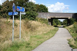
The Hudson Way is a 10 miles (16 km) walking and cycling route in the East Riding of Yorkshire, England. The route follows a disused railway line between the market towns of Market Weighton and Beverley.

National Cycle Network (NCN) Route 65 is a Sustrans National Route that runs from Hornsea on the North Sea Coast of The East Riding of Yorkshire via Hull and York to Middlesbrough. It is fully open and signed.

National Cycle Network (NCN) Route 665 is a Sustrans route from Wetherby to South West York. Two sections of the route are open. As of summer 2020 the route is not fully signed. The central section between Tadcaster and Newton Kyme is still a proposal.
National Cycle Network (NCN) Route 167 is a Sustrans regional route in the Yorkshire Wolds between Kirkham and Huggate. It is one of 5 NCN routes that make up the 146 mile Yorkshire Wolds Cycle Route. Created in 2011 it is fully open and signed.

National Cycle Network (NCN) Route 166 is a Sustrans regional route in the Yorkshire Wolds between Kirkham and Hunmanby. It is one of 5 NCN routes that make up the 146 mile Yorkshire Wolds Cycle Route. Created in 2011 it is fully open and signed.

National Cycle Network (NCN) Route 647 is a Sustrans National Route that runs from Clumber Park to Harby 53.233°N 0.683°W. The route is 19.6 miles (31.5 km) in length and is fully open and signed in both directions.
National Cycle Network (NCN) Route 64 is a Sustrans National Route that runs from Market Harborough to Lincoln. The route is 68 miles (109 km) in length and is fully open and signed in both directions. There are three sections to the route, NCN 63 and NCN 15 form the links between these sections.

National Cycle Network (NCN) Route 67 is a Sustrans National Route that runs from Long Whatton to Northallerton. The route is 124 miles (200 km) in length and is open but with sections missing.


