
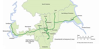
National Cycle Network (NCN) Route 62 is a Sustrans National Route that runs from Fleetwood to Selby. [1] As of 2018 the route has a missing section between Preston and Southport but is otherwise open and signed.
National Cycle Network (NCN) Route 62 is a Sustrans National Route that runs from Fleetwood to Selby. [1] As of 2018 the route has a missing section between Preston and Southport but is otherwise open and signed.
Much of route 62 was created as part of the Trans Pennine Trail, a long-distance path running from coast to coast across Northern England. It forms part of European walking route E8. [2] It was given the route number 62 in reference to the M62 motorway which it running parallel to between Liverpool and Selby.
The western trailhead is in Fleetwood. The route follows the coast on traffic-free paths to Lytham St Annes via Blackpool. From Lytham, the route follows minor roads to the western outskirts of Preston. Passing through the city centre the route reaches Hutton. From here to the northern edge of Southport the route has yet to be determined.

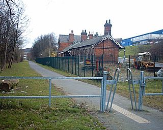
From Southport to Widnes the route is extensively traffic-free. [3] It is mainly made up of old railway lines including the Liverpool Loop Line through the city's eastern suburbs. [4] Continuing on canals and old railway lines between Widnes and Altrincham. The route then follows the River Mersey though Manchester southern suburbs to reach Stockport.
Route 62 continues from Stockport on a mixture of traffic-free and on-road routes. From Hadfield it crosses the Peak District, heading up the Longdendale valley via the Longdendale Trail to Woodhead, then down through Dunford Bridge, Penistone and Doncaster. The eastern trailhead is in Selby where it meets Route 65.
Several sections of Route 62 are signed as local routes or trails. These include:
Route 62 meets the following routes:
Route 62 is part of the Trans Pennine Trail (east) along with Route 65.
Route 62 is part of the Pennine Cycleway along with Route 68.

Longdendale is a valley in the Peak District of England, north of Glossop and southwest of Holmfirth. The name means "long wooded valley" and the valley is mostly in the counties of Derbyshire and Greater Manchester.

The River Etherow is a river in northern England, and a tributary of the River Goyt. Although now passing through South Yorkshire, Derbyshire and Greater Manchester, it historically formed the ancient county boundary between Cheshire and Derbyshire. The upper valley is known as Longdendale. The river has a watershed of approximately 30 square miles (78 km2), and the area an annual rainfall of 52.5 inches (1,330 mm).
The Trans Pennine Trail is a long-distance path running from coast to coast across Northern England entirely on surfaced paths and using only gentle gradients. It forms part of European walking route E8 and is part of the National Cycle Network as Route 62.

Dunford Bridge is a remote hamlet in the civil parish of Dunford, lying northwest of Sheffield in South Yorkshire, England, 1.3 miles (2 km) from the border with West Yorkshire and 2.3 miles (4 km) from the border with Derbyshire. It lies in the Peak District, 5 miles (8 km) west of Penistone and 5 miles (8 km) south of Holmfirth, within the Metropolitan Borough of Barnsley. Before the Local Government Act 1972 the area covered by South Yorkshire was part of the West Riding of Yorkshire.

The Lancashire and Yorkshire Railway (L&YR) was a major British railway company before the 1923 Grouping. It was incorporated in 1847 from an amalgamation of several existing railways. It was the third-largest railway system based in northern England.

The High Peak Trail is a 17-mile (27 km) trail for walkers, cyclists and horse riders in the Peak District of England. Running from Dowlow (53.2059°N 1.8349°W), near Buxton, to High Peak Junction, Cromford (53.1004°N 1.5354°W), it follows the trackbed of the former Cromford and High Peak Railway, which was completed in 1831 to carry minerals and goods between the Cromford Canal wharf at High Peak Junction and the Peak Forest Canal at Whaley Bridge.

The Huddersfield line is the main railway line between the English cities of Leeds and Manchester, via Huddersfield. It is one of the busiest MetroTrain lines. The route travels south-south-west from Leeds through Dewsbury. After a short westward stretch through Mirfield, where it runs on the ex-L&YR section, it continues south-west through Huddersfield, using the Colne Valley to its headwaters. The long Standedge Tunnel, just after Marsden, crosses under the watershed; the majority of the run down to Manchester is in the Tame Valley. From Manchester, some services continue to Manchester Airport and others to Liverpool.

The Woodhead line was a railway line linking Sheffield, Penistone and Manchester in the north of England. A key feature of the route is the passage under the high moorlands of the northern Peak District through the Woodhead Tunnels. The line was electrified in 1953 and closed between Hadfield and Penistone in 1981.

The Pennine Bridleway is a National Trail in Northern England.
The Pennine Cycleway is a Sustrans-sponsored route in the Pennines range in northern England, an area often called the "backbone of England". The route passes through the counties of Derbyshire, West Yorkshire, Lancashire, North Yorkshire, Cumbria and Northumberland. It is part of the National Cycle Network (NCN). Sustrans founder John Grimshaw calls it 'the best National Cycle Network route of the lot'.

Over the latter years of the 19th and early years of the 20th centuries, Penistone in Yorkshire gained a name as an accident black-spot on Britain's railway network; indeed, it could be said to hold the title of the worst accident black-spot in the country. The main line through the town was the Woodhead route of the Manchester, Sheffield and Lincolnshire Railway between Sheffield Victoria and Manchester, London Road. The line was heavily graded with a summit some 400 yards inside the eastern portal of the Woodhead tunnel.
Meadowhall and Wincobank railway station—also known in the 19th century as Meadow Hall at the time of the Meadow Hall Iron Works—was a railway station on the South Yorkshire Railway near Sheffield, England.

The A628 is a major road connecting Greater Manchester and South Yorkshire in northern England. It crosses the Pennine hills by way of Longdendale and the Woodhead Pass in the Peak District National Park. The road's altitude and exposure to bad weather create problems in winter and the road is sometimes closed due to snow or high winds.
National Cycle Route 6 is a route of the National Cycle Network, running from London to the Lake District.

National Cycle Network (NCN) Route 65 is a Sustrans National Route that runs from Hornsea on the North Sea Coast of The East Riding of Yorkshire via Hull and York to Middlesbrough. It is fully open and signed.

The Don Bridge is a motorway viaduct in South Yorkshire, England.

National Cycle Network (NCN) Route 688 is a Sustrans National Route that runs from Winterburn to Linton-on-Ouse. It is 55 miles (89 km), fully open and signed.

National Cycle Network (NCN) Route 67 is a Sustrans National Route that runs from Long Whatton to Northallerton. The route is 124 miles (200 km) in length and is open but with sections missing.

Cycling is a popular method of transport in the county of South Yorkshire, England. Between 2006 and 2014, there was an increase of over 25% in the number of cycle journeys being made in the county's urban areas.