
Longdendale is a valley in the Peak District of England, north of Glossop and southwest of Holmfirth. The name means "long wooded valley" and the valley is mostly in the counties of Derbyshire and Greater Manchester.
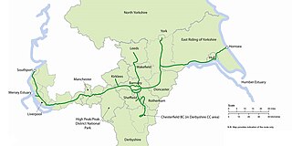
The Trans Pennine Trail is a long-distance path running from coast to coast across Northern England entirely on surfaced paths and using only gentle gradients. It forms part of European walking route E8 and is part of the National Cycle Network as Route 62.

The National Cycle Network (NCN) is the national cycling route network of the United Kingdom, which was established to encourage cycling and walking throughout Britain, as well as for the purposes of bicycle touring. It was created by the charity Sustrans who were aided by a £42.5 million National Lottery grant. However Sustrans themselves only own around 2% of the paths on the network, these rest being made of existing public highways and rights of way, and permissive paths negotiated by Sustrans with private landowners, which Sustrans have then labelled as part of their network.

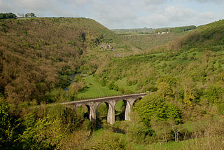
The High Peak Trail is a 17-mile (27 km) trail for walkers, cyclists and horse riders in the Peak District of England. Running from Dowlow (53.2059°N 1.8349°W), near Buxton, to High Peak Junction, Cromford (53.1004°N 1.5354°W), it follows the trackbed of the former Cromford and High Peak Railway, which was completed in 1831 to carry minerals and goods between the Cromford Canal wharf at High Peak Junction and the Peak Forest Canal at Whaley Bridge.

The Tissington Trail is a bridleway, footpath and cycleway in Derbyshire, England, along part of the trackbed of the former railway line connecting Ashbourne to Buxton. It takes its name from the village of Tissington, which it skirts. Opened in 1971, and now a part of the National Cycle Network, it stretches for 13 miles (21 km) from Parsley Hay (53.1706°N 1.7828°W) in the north to Ashbourne (53.0196°N 1.7397°W) in the south.

The Midshires Way is a long-distance footpath and bridleway that runs for 230 miles (370 km) from the Chiltern Hills from near Bledlow in Buckinghamshire, through the Midlands counties of Northamptonshire, Leicestershire, Nottinghamshire and Derbyshire, to Stockport, Greater Manchester. It also links several other long-distance walking routes or trackways including The Ridgeway, the Pennine Bridleway and the Trans Pennine Trail.

The Pennine Bridleway is a National Trail in Northern England.

Parsley Hay railway station served Parsley Hay, a hamlet within Hartington Middle Quarter civil parish, about 9.3 miles (15 km) south east of Buxton, Derbyshire, on the LNWR line to Ashbourne. The nearest large settlement is the village of Hartington.
Thorpe Cloud railway station was opened in 1899 between the villages of Thorpe and Fenny Bentley in Derbyshire, south east of Buxton.

Hartington railway station opened in 1899 about two miles away from the village it served - Hartington in Derbyshire, south east of Buxton.

Ashbourne railway station formerly served the town of Ashbourne in Derbyshire. There have been two stations in the town. The first, opened in 1852, was operated by the North Staffordshire Railway (NSR); it was replaced in 1899 by a station at a new location, jointly operated by the NSR and the London and North Western Railway (LNWR). In 1923 the station passed into the ownership of the London, Midland and Scottish Railway and in 1948 that of the London Midland Region of British Railways. It was finally closed to all traffic in 1963.

National Cycle Network (NCN) Route 69 is a Sustrans National Route that runs from Hest Bank to Cleethorpes. The route is incomplete and consists of one long section in Lancashire, and seven short sections in West Yorkshire. The open sections are signed in both directions.

National Cycle Network (NCN) Route 62 is a Sustrans National Route that runs from Fleetwood to Selby. As of 2018 the route has a missing section between Preston and Southport but is otherwise open and signed.

National Cycle Network (NCN) Route 65 is a Sustrans National Route that runs from Hornsea on the North Sea Coast of The East Riding of Yorkshire via Hull and York to Middlesbrough. It is fully open and signed.
National Cycle Network (NCN) Route 70 is a Sustrans National Route that runs from Walney Island in Cumbria to Sunderland. The route is fully open and signed. From end to end the route is 149 miles (240 km), but two sections are shared with other NCN routes leaving Route 70 at 128 miles (206 km).
The White Peak Loop is a 60-mile (97 km) route for walking, cycling and horse riding in the Peak District of England. The trail combines sections of the High Peak Trail and the Monsal Trail with linking sections through the towns of Buxton, Bakewell and Matlock. The White Peak Loop is being developed by Derbyshire County Council and as of 2022 some sections are not yet complete.

The Bay Cycle Way is an 80-mile (130 km) cycling route around Morecambe Bay in Lancashire and Cumbria in north west England. Most of it forms National Cycle Route 700, while other sections are waymarked as NCN 6, NCN 69 and NCN 70.

National Cycle Network (NCN) Route 67 is a Sustrans National Route that runs from Long Whatton to Northallerton. The route is 124 miles (200 km) in length and is open but with sections missing.
 Ashbourne Tunnel on the Tissington Trail, Derbyshire
 On a section of the Midshires Way near Buxton, Derbyshire
 Longdendale Trail at Woodhead Reservoir on NCN 62
 New bridge on the River Calder at Sowerby Bridge, West Yorkshire
 On the West Yorkshire, Lancashire border half-way between Hebden Bridge and Burnley
 Signpost at Dufton, Cumbria
 Signpost near Slaggyford, Northumberland
 On the South Tyne Trail near Lambley, Northumberland
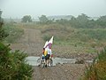 Ford over the river Breamish at Brandon, Northumberland
 The Union Chain Bridge crossing the River Tweed on NCN 1


