
Harborough is a local government district of Leicestershire, England, named after its main town, Market Harborough. Covering 230 square miles (600 km2), the district is by far the largest of the eight district authorities in Leicestershire and covers almost a quarter of the county. The district also covers the town of Lutterworth and villages of Broughton Astley and Ullesthorpe.

Melton is a local government district with borough status in north-eastern Leicestershire, England. It is named after its main town, Melton Mowbray. Other settlements include Asfordby and Bottesford. At the 2011 census, it had a population of 50,376.
Rushcliffe is a local government district with borough status in Nottinghamshire, England. The population of the Local Authority at the 2011 Census was 111,129. Its council, Rushcliffe Borough Council(0115 981 9911), is based in West Bridgford. It was formed on 1 April 1974 by merging the West Bridgford Urban District, the Bingham Rural District and part of Basford Rural District.

The Vale of Belvoir covers adjacent areas of Leicestershire, Nottinghamshire and Lincolnshire, England. The name derives from the Norman-French for "beautiful view" and dates back to Norman times.

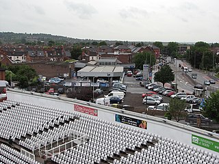
Melton Mowbray railway station serves the market town of Melton Mowbray in Leicestershire, England. It is owned by Network Rail and operated by East Midlands Railway, though CrossCountry operates most of the services as part of its Birmingham New Street to Stansted Airport route. The station is on the route of the Syston and Peterborough Railway, which is now part of the Birmingham to Peterborough Line. It has a ticket office, which is staffed part-time, a car park, and help points for times when no staff are present.
Harby & Stathern railway station is a former station on the Great Northern and London and North Western Joint Railway that served the villages of Harby and Stathern, in Leicestershire, England.

National Cycle Route 1 is a route of the National Cycle Network, running from Dover to Tain. The 1,264 mi-long (2,034-kilometre) cycle-path is located in the United Kingdom.

The A607 is an A road in England that starts in Belgrave, Leicester and heads northeastwards through Leicestershire and the town of Grantham, Lincolnshire, terminating at Bracebridge Heath, a village on the outskirts of Lincoln. It is a primary route from Thurmaston to the A1 junction at Grantham.

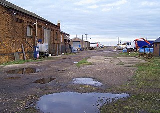
Doddington and Harby railway station is a former railway station on the Nottinghamshire border with Lincolnshire, England.
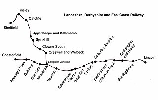
Skellingthorpe railway station is one of two former railway station in Skellingthorpe, Lincolnshire, England, on the border with Nottinghamshire.
The Great Northern and London and North Western Joint Railway was a British railway line, almost entirely within Leicestershire. Authorised by the same Act of Parliament, the Great Northern Railway Leicester Branch was built, branching from the Joint Line; on the same basis the Newark to Bottesford Line was built. The lines opened progressively between 1879 and 1883. The dominant traffic was iron ore, and the agricultural produce of the area served also generated considerable business. The passenger usage was never heavy, although some unusual through services were attempted at first.
Melton Mowbray North railway station was a railway station in Melton Mowbray, Leicestershire, England on the Great Northern and London and North Western Joint Railway.
Pyewipe Junction engine shed was a motive power depot operated by the Great Eastern Railway (GER) located in Lincolnshire, England.

National Cycle Network (NCN) Route 65 is a Sustrans National Route that runs from Hornsea on the North Sea Coast of The East Riding of Yorkshire via Hull and York to Middlesbrough. It is fully open and signed.

National Cycle Network (NCN) Route 665 is a Sustrans route from Wetherby to South West York. Two sections of the route are open. As of summer 2020 the route is not fully signed. The central section between Tadcaster and Newton Kyme is still a proposal.
National Cycle Network (NCN) Route 167 is a Sustrans regional route in the Yorkshire Wolds between Kirkham and Huggate. It is one of 5 NCN routes that make up the 146 mile Yorkshire Wolds Cycle Route. Created in 2011 it is fully open and signed.

National Cycle Network (NCN) Route 647 is a Sustrans National Route that runs from Clumber Park to Harby 53.233°N 0.683°W. The route is 19.6 miles (31.5 km) in length and is fully open and signed in both directions.

National Cycle Network (NCN) Route 67 is a Sustrans National Route that runs from Long Whatton to Northallerton. The route is 124 miles (200 km) in length and is open but with sections missing.

Staunton is a small village and civil parish in the Newark and Sherwood district of Nottinghamshire, England. It takes its name from the Vale of Belvoir and shares it with the local Staunton family, which has resided in the area since the Norman Conquest and possibly before, making them one of the English families living longest on its own estate.
