The North Western Railway (NWR) was an early British railway company in the north-west of England. It was commonly known as the "Little" North Western Railway, to distinguish it from the larger London and North Western Railway (LNWR).

Cullingworth is a village and civil parish in the City of Bradford, West Yorkshire, England. Within the boundaries of the historic West Riding of Yorkshire, it is 7 miles (11 km) west of Bradford and 3 miles (5 km) south of Keighley. The surrounding countryside is mainly used for sheep and cattle farming, with areas of moorland lying to the north and west.
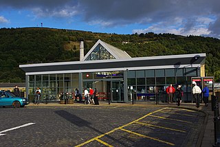
Halifax railway station serves the town of Halifax in West Yorkshire, England. It lies on the Calder Valley line and is 17 miles (27 km) west from Leeds.
The Pennine Cycleway is a Sustrans-sponsored route in the Pennines range in northern England, an area often called the "backbone of England". The route passes through the counties of Derbyshire, West Yorkshire, Lancashire, North Yorkshire, Cumbria and Northumberland. It is part of the National Cycle Network (NCN). Sustrans founder John Grimshaw calls it 'the best National Cycle Network route of the lot'.
The Queensbury lines was the name given to a number of railway lines in West Yorkshire, England, that linked Bradford, Halifax and Keighley via Queensbury. All the lines were either solely owned by the Great Northern Railway (GNR) or jointly by the GNR and the Lancashire and Yorkshire Railway (L&YR). The terrain was extremely challenging for railway construction, and the lines were very expensive to build. The lines were

National Cycle Route 1 is a route of the National Cycle Network, running from Dover to Tain. The 1,264 mi-long (2,034-kilometre) cycle-path is located in the United Kingdom.

Queensbury railway station was a station on the Queensbury lines serving the village of Queensbury, West Yorkshire, England. The station was unusual due to its triangular shape, and at its opening the only other examples of this arrangement were Ambergate station in Derbyshire and Earlestown in Lancashire; since then Shipley station, also in West Yorkshire, has gained platforms on all three sides. Of the stations on the Queensbury lines, this was the most ambitious.

St Dunstans railway station is a closed station in the city of Bradford, West Yorkshire, England. The station was the location of a three-way junction with platforms on two of the lines.
National Cycle Network (NCN) Route 66 is a Sustrans National Route that runs from Kingston upon Hull to Manchester via Beverley, York and Leeds.

The Way of the Roses is the newest of Great Britain's coast-to-coast, long-distance cycle routes and is based on minor roads, disused railway lines and specially constructed cycle paths. It lies entirely within the counties of Lancashire and Yorkshire, crossing the Yorkshire Dales and the Yorkshire Wolds in the north of England, passing through the historic cities of Lancaster and York and scenic towns and villages including Settle, Pateley Bridge and Ripon.
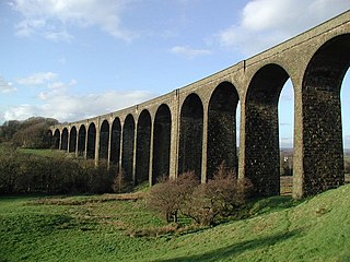
Hewenden Viaduct, situated near Cullingworth, West Yorkshire, England, originally served as a railway viaduct along the Queensbury Lines. Being one of the highest viaducts in Britain, it has been recognised as a Grade II listed structure.

Lees Moor Tunnel is an abandoned tunnel on the former Great Northern Railway line between Queensbury and Keighley in West Yorkshire, England. The former dual track tunnel is just north of the village of Cullingworth in West Yorkshire and when built was 1,533 yards (1,402 m) long. Due to the pitch black inside and the squealing of the wheels on the 1 in 50 radius curve, drivers nicknamed it the 'Hell Hole'. After closure to passengers, the tunnel was used in experiments involving the effects of smoke inhalation and cancer.

National Cycle Network (NCN) Route 65 is a Sustrans National Route that runs from Hornsea on the North Sea Coast of The East Riding of Yorkshire via Hull and York to Middlesbrough. It is fully open and signed.

National Cycle Network (NCN) Route 658 is a Sustrans Regional Route. It is two miles (3.2 km) long, and provides a connection between Route 65 and Route 66 through York city centre. The full length of the route is part of the Way of the Roses. It is fully signed and open.

National Cycle Network (NCN) Route 164 is a Sustrans regional route in the Yorkshire Wolds. The Northern section between Pocklington and Hutton Cranswick is part of the Way of the Roses, opened in 2010. The southern section links Beverley and Kiplingcotes via Newbold. Both sections are key parts of the 146 mile Yorkshire Wolds Cycle Route, opened in 2011. It is fully open and signed.

The Great Northern Railway Trail is a cycleway and footpath in the Bradford District of West Yorkshire, England. The path follows the route of a former railway, that of the Great Northern railway line between Bradford and Keighley that went via Queensbury and Cullingworth. The path has been designated as part of the National Cycle Route number 69.

Queensbury Tunnel is a disused railway tunnel that connects Holmfield and Queensbury in West Yorkshire, England. It was built by the Great Northern Railway (GNR) and, at 2,287 m (7,503 ft) in length, was the longest on the company's network at the time of its opening in 1878. The line through the tunnel closed in 1956.
National Cycle Network (NCN) Route 688 is a Sustrans National Route that runs from Winterburn to Linton-on-Ouse. It is 55 miles (89 km), fully open and signed.

The Bay Cycle Way is an 80-mile (130 km) cycling route around Morecambe Bay in Lancashire and Cumbria in north west England. Most of it forms National Cycle Route 700, while other sections are waymarked as NCN 6, NCN 69 and NCN 70.
