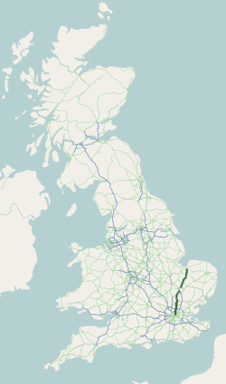
National Cycle Route 11

Last updated

National Cycle Route 11 is a bikeway in England on the UK's National Cycle Network, connecting Harlow in Essex to King's Lynn in Norfolk.

Contents

Route

Harlow to Cambridge

NCR 11 near Great Shelford, showing a double helix and a small part of the BRCA2 gene. National Cycle Route 11 at Great Shelford.jpg
NCR 11 near Great Shelford, showing a double helix and a small part of the BRCA2 gene.

Harlow | Bishop Stortford | Hinxton | Sawston | Cambridge

Route 11 is planned to start in Harlow at a junction with route 1. However, aside from a short section of off road cycle path near Bishops Stortford, there is no route before Standsted Mountfitchet. Here a delisted section on country lanes heads north to near Audley End station where the listed section continues north to Ickleton and Duxford. Off road sections via Sawston lead to an off road path parallel with the railway at Great Shelford.

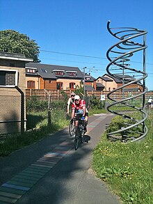
This section of the cycle path, about two kilometres (one and a quarter miles) long, from Great Shelford to Addenbrooke's Hospital in Cambridge, is decorated with 10,257 lines of four colours representing the nucleotide sequence of the BRCA2 gene. This gene, implicated in early-onset breast cancer, was discovered in 1994; the discoverers included scientists from nearby Addenbrooke's Hospital and the Sanger Institute, Hinxton. [1]

This section of path also includes and commemorates the 10,000th mile of the National Cycle Network. It is fondly referred to by regular users as "The DNA path". It offers a fine view of White Hill and Clarke's Hill, which are the northernmost peaks of the Gog Magog Hills.

Route 11 intersects with National Cycle Route 51 in Cambridge.

Cambridge to King's Lynn

Cambridge | Burwell | Wicken | Ely | Downham Market | Watlington | King's Lynn

Intersects with National Cycle Route 1 near King's Lynn

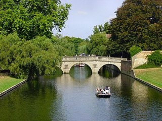
Route 11 passes through the historic centre of Cambridge passing buildings including Kings College Chapel. Leaving the city, the cycle path uses the south bank of the River Cam before crossing to the north side and following the riverside path to Waterbeach station. Here there is a gap in the cycle route to Bottisham Lode. Cyclists heading further north should therefore follow route 51 via Fen Ditton, Bottisham and Lode to join route 11 again at Bottisham Lode.

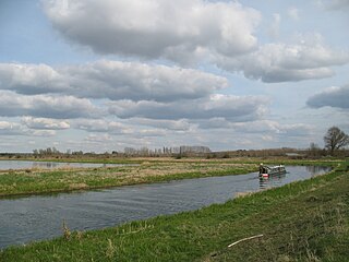
The next section of the route to Wicken Fen nature reserve uses a sequence of roads, tracks and bridges across the fenland called the Lodes Way. There is a challenging footbridge with cycle channels at Burwell Lode which is very steep. At Wicken Fen there is a visitor centre with cafe and cycle hire. Route 11 then follows country lanes and the River Ouse to Ely where route 11 passes Ely Cathederal.

Leaving Ely, route 11 is signed to Little Downham, but then delisted to Ten Mile Bank as the roads are now too busy to be safe for family cycling, particularly the section on the A1101. However, this route can still be followed and is still shown on Ordnance Survey maps. This section passes the Welney Wetland Centre.

From Ten Mile Bank, route 11 mostly follows country lanes via Downham Market and Watlington to a junction with National Cycle Route 1 near Wiggenhall St Germans. Route 1 can then be followed into the centre of Kings Lynn along the east bank of the River Great Ouse.

Related Research Articles

<span class="mw-page-title-main">Cambridgeshire</span> County of England

Cambridgeshire is a ceremonial county in the East of England and East Anglia. It is bordered by Lincolnshire to the north, Norfolk to the north-east, Suffolk to the east, Essex and Hertfordshire to the south, and Bedfordshire and Northamptonshire to the west. The largest settlement is the city of Peterborough, and the city of Cambridge is the county town.

<span class="mw-page-title-main">River Cam</span> Tributary of the River Great Ouse

The River Cam is the main river flowing through Cambridge in eastern England. After leaving Cambridge, it flows north and east before joining the River Great Ouse to the south of Ely, at Pope's Corner. The total distance from Cambridge to the sea is about 40 mi (64 km) and is navigable for punts, small boats, and rowing craft. The Great Ouse also connects to England's canal system via the Middle Level Navigations and the River Nene. In total, the Cam runs for around 69 kilometres (43 mi) from its furthest source to its confluence with the Great Ouse.

<span class="mw-page-title-main">River Little Ouse</span> River in east England

The River Little Ouse, also known as the Brandon River, is a river in the east of England, a tributary of the River Great Ouse. For much of its length it defines the boundary between Norfolk and Suffolk.

<span class="mw-page-title-main">Uttlesford</span> Non-metropolitan district in England

Uttlesford is a local government district in Essex, England. Its council is based in the town of Saffron Walden. The district also includes the town of Great Dunmow and numerous villages, including Stansted Mountfitchet, Takeley, Elsenham, Thaxted, and Newport. The district covers a largely rural area in the north-west of Essex. London Stansted Airport lies within the district.

<span class="mw-page-title-main">A10 road (England)</span> Road in England

The A10 is a major road in England which runs between The City of London and King's Lynn in Norfolk.

<span class="mw-page-title-main">Fen Rivers Way</span>

The Fen Rivers Way is a long distance footpath that spans a distance of 50 miles (80 km). It runs between the City of Cambridge and the town of King's Lynn in West Norfolk. It follows the course of the River Cam and River Great Ouse across the Fenland landscape into the Wash. It provides a small part of European Long Distance Path E2 which goes from Nice to Galway.

<span class="mw-page-title-main">Fen line</span> Railway line in East Anglia, UK

The Fen Line is a railway line in the east of England that links Cambridge in the south to King's Lynn in the north. The line runs through Cambridgeshire and Norfolk and the name of the line refers to the Fens which cover parts of Cambridgeshire, Norfolk and Lincolnshire. It is 41 miles 47 chains (66.9 km) in length and has eight stations.

<span class="mw-page-title-main">Wicken Fen</span> Nature reserve in Cambridgeshire, United Kingdom

Wicken Fen is a 254.5-hectare (629-acre) biological Site of Special Scientific Interest west of Wicken in Cambridgeshire. It is also a National Nature Reserve, and a Nature Conservation Review site. It is protected by international designations as a Ramsar wetland site of international importance, and part of the Fenland Special Area of Conservation under the Habitats Directive.

<span class="mw-page-title-main">Watlington, Norfolk</span> Human settlement in England

Watlington is a village, civil parish and electoral ward in the English county of Norfolk. It covers an area of 6.93 km2 (2.68 sq mi) and had a population of 2,031 in 852 households at the 2001 census, the population increasing to 2,455 at the 2011 Census. It is in the district of King's Lynn and West Norfolk.

<span class="mw-page-title-main">Stow cum Quy</span> Human settlement in England

Stow cum Quy, commonly referred to as Quy, is a village and civil parish in Cambridgeshire, England. Situated around 4 miles (6.4 km) north east of Cambridge lying between the Burwell Road (B1102) and the medieval Cambridge to Newmarket road, it covers an area of 764 hectares.

National Cycle Route 51 is an English long distance cycle route running broadly east-west connecting Colchester and the port of Harwich to Oxford via Ipswich, Bury St Edmunds, Cambridge, Bedford, Milton Keynes, Bicester, and Kidlington.

<span class="mw-page-title-main">Downham West</span> Human settlement in England

Downham West is a civil parish in the English county of Norfolk The parish is 47.6 miles (76.6 km) west of Norwich, 16.3 miles (26.2 km) south-south-west of King's Lynn and 96.2 miles (154.8 km) north of London. The nearest town is Downham Market which is 2.5 miles (4.0 km) north east of the parish. The nearest railway station is at Downham Market for the Fen Line which runs between King's Lynn and Cambridge. The nearest airport is Norwich International Airport. The parish of Downham West, in the 2001 census, has a population of 285, rising marginally to 286 at the Census 2011. For the purposes of local government, the parish falls within the district of King's Lynn and West Norfolk.

<span class="mw-page-title-main">Cambridgeshire Lodes</span> Man-made waterways in the county of Cambridgeshire, England

The Cambridgeshire Lodes are a series of man-made waterways, believed to be Roman in origin, located in the county of Cambridgeshire, England. Bottisham, Swaffham Bulbeck, Reach, Burwell, Wicken and Monks Lodes all connect to the River Cam, while Soham and Cottenham Lodes connect to the River Great Ouse. All have been navigable historically, but some are no longer officially navigable.

References

  1. Gibson, Susannah (10 March 2012). "DNA Cycle Path, Cambridge, England". bshs.org.uk. Cambridge: British Society for the History of Science. Archived from the original on 28 August 2020. Retrieved 28 August 2020.