Encinitas is a beach city in the North County area of San Diego County, California. Located within Southern California, it is approximately 25 miles (40 km) north of San Diego, between Solana Beach and Carlsbad, and about 95 miles (153 km) south of Los Angeles. As of the 2020 United States census, the city had a population of 62,007, up from 59,518 at the 2010 census.

Rancho Santa Fe is a census-designated place (CDP) in San Diego County, California, United States, within the San Diego metropolitan area. The population was 3,156 at the 2020 census. The CDP is primarily residential with a few shopping blocks, a middle and elementary school, and several restaurants.

North County is a region in the northern area of San Diego County, California. It is the second-most populous region in the county, with an estimated population of 869,322. North County is well known for its affluence, especially in Encinitas, Carlsbad, Del Mar, Rancho Santa Fe, and Solana Beach, where house prices range, on average, above $1,000,000. Cities along the 78 freeway have more mixed incomes.

San Dieguito Union High School District (SDUHSD) is a public school district in northern San Diego County, California. Established in 1936, the district serves over 13,000 students in five middle schools, five comprehensive high schools, and one alternative high school.

Carmel Valley is a suburban planned community in the northwestern corner of San Diego, California, United States. The community is composed of commercial offices, residential units, hotels, retail stores and restaurants.
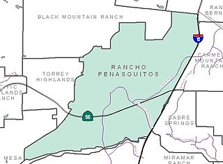
Rancho Peñasquitos is a suburban community in the northeastern part of the city of San Diego, California. It is named after the first Mexican land grant in the county, Rancho Santa Maria de Los Peñasquitos. The community abuts Los Peñasquitos Canyon Preserve, an open space preserve that offers hiking, biking, and equestrian trails. The community is commonly abbreviated "PQ."

Black Mountain Ranch is a suburban community in the northern part of the city of San Diego, California. Black Mountain Ranch encompasses 5,100 acres (21 km2) and is located north of Rancho Peñasquitos and Torrey Highlands, south of the Santa Fe Valley, east of Fairbanks Ranch and Rancho Santa Fe, and west of 4S Ranch.

4S Ranch is a locale of San Diego County, California. It is located about 25 miles (40 km) north of downtown San Diego and 13 miles (21 km) east of the Pacific Ocean in the North County Inland area of San Diego. To the east of 4S Ranch is the San Diego community of Rancho Bernardo. To the west is the Santa Fe Valley, which includes Rancho Santa Fe. Lake Hodges forms the northern border of the community while Black Mountain Ranch, which includes Del Sur and Santaluz, and Rancho Peñasquitos are both situated to the south. The ZIP Code is 92127, and the community is inside area code 858.
San Pasqual Valley, historically spelled as San Pascual, is the northernmost community of the city of San Diego. It is named for the Kumeyaay village of San Pasqual that was once located there. It is bordered on the north by the city of Escondido, on the east and west by unincorporated land within San Diego County, and on the south by the city of Poway and the community of Rancho Bernardo. San Pasqual Valley is home to the San Diego Zoo Safari Park.

Carmel Mountain Ranch, sometimes shortened to simply Carmel Mountain, or abbreviated to CMR by local residents and organizations is a community of San Diego, California, United States, in the northeastern part of the city. Despite its name, Carmel Mountain Ranch is actually in the shadow of Black Mountain. Carmel Mountain proper is about 10 miles west of the Carmel Mountain Ranch neighborhood.
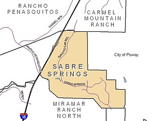
Sabre Springs is a community in San Diego, California, located in the northeastern part of the city. It is bounded by the city limits of Poway on the east, Ted Williams Parkway on the north, Interstate 15 on the west, and the community of Miramar Ranch North to the south. Sabre Springs is bisected north-south by Poway Road.
Elfin Forest is an unincorporated residential community of San Diego County, California, United States, in the foothills of the Santa Rosa Mountains. The community is southwest of Escondido and according to the USGS it is located at 33°04′25″N117°09′51″W in the Escondido ZIP code of 92029. It borders the rural, unincorporated town of Harmony Grove to the northeast, San Marcos to the north and west, Olivenhain to the southwest, and Rancho Santa Fe to the south.

Pacific Highlands Ranch is a primarily residential community of approximately 2,652 acres (1,073 ha) in northern San Diego, California. As part of San Diego City Council District 1, it is represented by Joe LaCava, elected in 2020, and as part of District 3 of the San Diego County Board of Supervisors, it is represented by Terra Lawson-Remer, also elected in 2020. Both had not been elected to those positions before.
San Dieguito Heritage Museum is a history museum in Encinitas, California, in the United States. Founded in 1988, the museum displays historical photographs and artifacts from Encinitas and the entire San Dieguito area.

Lake Hodges is a lake and reservoir located within the city limits of San Diego, California. It is about 31 miles (50 km) north of Downtown San Diego, just north of the Rancho Bernardo community, and just south of the city's border with Escondido. When full, the reservoir has 1,234 acres (4.99 km2), a maximum water depth of 115 feet (35 m), and 27 miles (43 km) of shoreline. Lake Hodges has a total capacity of 30,251 acre-feet of water. Lake Hodges is owned by the city of San Diego, supplies water to the San Dieguito Water District and Santa Fe Irrigation District, and its mailing city address is Escondido.
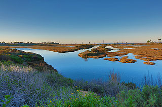
San Elijo Lagoon Ecological Reserve is one of the largest remaining coastal wetlands in San Diego County, California, United States.
Rancho Las Encinitas was a 4,434-acre (17.94 km2) Mexican land grant in present-day San Diego County, California given in 1842 by Governor Juan Alvarado to Andrés Ybarra. The grant was named “Los Encinitos” which means " little oaks", but was later misspelled as “Las Encinitas”. The grant extended along the Pacific coast north from San Elijo Lagoon to Batiquitos Lagoon, and encompassed present-day Leucadia, Encinitas, Cardiff-by-the-Sea and Olivenhain, California.
Fairbanks Ranch Country Club is a neighborhood and private golf club located in northern San Diego, California. The area is bordered by the unincorporated San Diego County communities of Rancho Santa Fe to the north and Fairbanks Ranch to the east, the City of San Diego neighborhood of Pacific Highlands Ranch to the south, and undeveloped natural areas of North City, San Diego to the west.

Bumann Ranch is a ranch in Encinitas, California. Previously owned by German colonists, it was added to the National Register of Historic Places on March 6, 2020. Currently, the ranch contains twenty buildings on its 10 acres of land.