
The history of the Cape Colony from 1806 to 1870 spans the period of the history of the Cape Colony during the Cape Frontier Wars, which lasted from 1779 to 1879. The wars were fought between the European colonists and the native Xhosa who, defending their land, fought against European rule.

The Eastern Cape is one of the provinces of South Africa. Its capital is Bhisho, but its two largest cities are East London and Gqeberha.

Makhanda, also known as Grahamstown, is a city of about 140,000 people in the Eastern Cape province of South Africa. It is situated about 110 kilometres (70 mi) northeast of Port Elizabeth and 130 kilometres (80 mi) southwest of East London. Makhanda is the largest town in the Makana Local Municipality, and the seat of the municipal council. It also hosts Rhodes University, the Eastern Cape Division of the High Court, the South African Library for the Blind (SALB), a diocese of the Anglican Church of Southern Africa, and 6 South African Infantry Battalion. Furthermore, located approximately 3 km south-east of the town lies the world renowned Waterloo Farm, the only estuarine fossil site in the world from 360 million years ago with exceptional soft-tissue preservation.

Port Elizabeth, officially renamed Gqeberha and colloquially often referred to as P.E., is a major seaport and the most populous city in the Eastern Cape province of South Africa. It is the seat of the Nelson Mandela Bay Metropolitan Municipality, South Africa's second-largest metropolitan district by area size. It is the sixth-most-populous city in South Africa and is the cultural, economic and financial centre of the Eastern Cape.

The amaMfengu' was a reference of Xhosa clans, whose ancestors were refugees that fled from the Mfecane in the early 19th century to seek land and protection from the Xhosa Nation, and have since been assimilated into the Xhosa cultural way of life, becoming part of the Xhosa people. The term derives from the Xhosa verb "ukumfenguza" which means to wander about seeking service.

Qonce, also known as King William's Town, is a town in the Eastern Cape province of South Africa along the banks of the Buffalo River. The city is about 60 kilometres (37 mi) northwest of the Indian Ocean port of East London. Qonce, with a population of around 35,000 inhabitants, forms part of the Buffalo City Metropolitan Municipality.

Fort Beaufort is a town in the Amatole District of South Africa's Eastern Cape Province, and had a population of 25,668 in 2011. The town was established in 1837 and became a municipality in 1883. The town lies at the confluence of the Kat River and Brak River between the Keiskamma and Great Fish Rivers. Fort Beaufort serves as a mini-'dormitory' for academic staff and students of Fort Hare University, based in the nearby town of Alice, and is also close to Sulphur Springs.
Ngcobo is a town in the Eastern Cape province of South Africa.
The Cape Mounted Riflemen were South African military units.
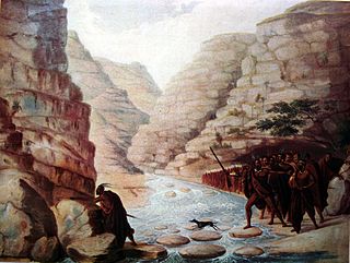
The Xhosa Wars were a series of nine wars between the Xhosa Kingdom and the British Empire as well as Trekboers in what is now the Eastern Cape in South Africa. These events were the longest-running military action in the history of European colonialism in Africa.

Butterworth is a town in the Eastern Cape Province, South Africa. Butterworth has a population of 45,900 and is situated on the N2 national highway 111 km north of East London.
Whittlesea is a semi-rural town situated in the Hewu district, 37 km south of Queenstown, Eastern Cape Province, South Africa. The town is made up of the townships Ekuphumleni, Bhede, Extension 4, Extension 5 and Sada. The town falls under the Enoch Mgijima Local Municipality which is under the Chris Hani District Municipality. Surrounding Whittlesea are 36 villages which make up the Hewu district.
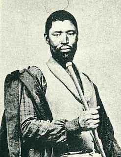
Mgolombane Sandile (1820–1878) was a ruler of the Right Hand House of the Xhosa Kingdom. A dynamic leader, he led the Xhosa armies in several of the Xhosa-British Wars.
Ngqushwa Local Municipality is an administrative area in the Amatole District of the Eastern Cape in South Africa.

Coffee Bay is a town on the Wild Coast of the Eastern Cape Province of South Africa. It is located about 250 kilometres south of the city of Durban and has a population of 258 people.
Qumbu is a town in O.R.Tambo District Municipality in the Eastern Cape province of South Africa.
Tsolo is a town in Mhlontlo Local Municipality in O.R.Tambo District of the Eastern Cape province of South Africa.
Cala is a town in Sakhisizwe Local Municipality, part of the Chris Hani District Municipality in the Eastern Cape province of South Africa.
Nompumelelo Hospital is a Provincial government funded hospital for the Ngqushwa Local Municipality area in Peddie, Eastern Cape in South Africa.
Emnyameni is a Xhosa community in Amahlathi Local Municipality within the Amathole District Municipality in the Eastern Cape province of South Africa, situated about 13 km north-west of Keiskammahoek. The community sits at the foot of the Mt Geju and Mt Belekumntana. It is made up of two villages, aptly named the Upper Emnyameni and the Lower Emnyameni.


