
San Bernardino County, officially the County of San Bernardino, is a county located in the southern portion of the U.S. state of California, and is located within the Inland Empire area. As of the 2020 U.S. Census, the population was 2,181,654, making it the fifth-most populous county in California and the 14th-most populous in the United States. The county seat is San Bernardino.
Ridgecrest is a city in Kern County, California, United States, along U.S. Route 395 in the Indian Wells Valley in northeastern Kern County, adjacent to the Naval Air Weapons Station China Lake. It was incorporated as a city in 1963. The population was 27,959 at the 2020 census, up slightly from 27,616 at the 2010 census.

Victorville is a city in Victor Valley in San Bernardino County, California. Its population as of the 2020 census was 134,810.

The Mojave Desert is a desert in the rain shadow of the Sierra Nevada mountains in the Southwestern United States. It is named for the indigenous Mojave people. It is located primarily in southeastern California and southwestern Nevada, with small portions extending into Arizona and Utah.

The Mojave River is an intermittent river in the eastern San Bernardino Mountains and the Mojave Desert in San Bernardino County, California, United States. Most of its flow is underground, while its surface channels remain dry most of the time, except for the headwaters and several bedrock gorges in the lower reaches.

Fort Irwin National Training Center is a major training area for the United States military in the Mojave Desert in northern San Bernardino County, California. Fort Irwin is at an average elevation of 2,454 feet (748 m). It is located 37 miles (60 km) northeast of Barstow, in the Calico Mountains.
Baker is a census-designated place located in San Bernardino County, California, US. As of the 2010 census, the CDP had a total population of 735. Baker's ZIP Code is 92309 and the community is within area codes 442 and 760.
Searles Valley is a valley in the northern Mojave Desert of California, with the northern half in Inyo County and the southern half in San Bernardino County, California, United States.
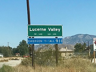
Lucerne Valley is a census-designated place (CDP) and valley landform in the southern Mojave Desert, in western San Bernardino County, California.

Searles Lake is an endorheic dry lake in the Searles Valley of the Mojave Desert, in northwestern San Bernardino County, California. The lake in the past was also called Slate Range Lake and Borax Lake.
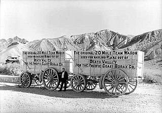
The Pacific Coast Borax Company (PCB) was a United States mining company founded in 1890 by the American borax magnate Francis Smith, the "Borax King".

Helendale or Silver Lakes is an unincorporated community and census-designated place located in the Victor Valley of the Mojave Desert, within San Bernardino County, California.
Grass Valley may refer to:

High Desert is a vernacular region with non-discrete boundaries applying to areas of the western Mojave Desert in southern California. The "High Desert" region is an area that generally is situated between 2,000 feet (610 m) and 4,000 feet (1,200 m) in elevation, and located just north of the San Gabriel, San Bernardino, and Little San Bernardino Mountains.
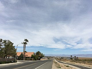
Oak Hills is a census-designated place in the Victor Valley of the Mojave Desert, within San Bernardino County, California.

Searles Valley is a census-designated place (CDP) in the Searles Valley of the Mojave Desert, in northwestern San Bernardino County, California.
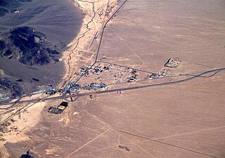
Trona is an unincorporated community in San Bernardino County, California. In 2015 it had a population of approximately 1,900. Trona is at the western edge of Searles Lake, a dry lake bed in Searles Valley, southwest of Death Valley. The town takes its name from the mineral trona, abundant in the lakebed. It is about 170 miles (274 km) northeast of Los Angeles, on State Route 178. The ZIP code is 93562.
Argus is an unincorporated community in the Searles Valley of the Mojave Desert, in northwestern San Bernardino County, California. Argus is 17 miles (27 km) east-northeast of Ridgecrest.

The Potash wars were a series of events that took place from 1910 to 1915 in the Searles Valley near Searles Lake, a dry lake, near the current town of Trona in the San Bernardino County of California. The Potash wars gained national and international news at the time due to the involvement of famous lawman Wyatt Earp and the importance of the valley's supply of potash at the time. Potash is an important crop fertilizer and the Searles Valley was a major supplier in the 1910s.


