Tourism is the primary economic generator for the area, contributing several million dollars per year to the county and providing hundreds of full-time and part-time jobs for local residents.[4] The area is host to over four million visitors a year. Lake Arrowhead offers over 1,600 guest accommodations, including more than 1,200 licensed vacation rentals on platforms like Airbnb and VRBO, around 175 rooms at the Lake Arrowhead Resort & Spa, and over 100 rooms at the UCLA Lake Arrowhead Lodge.[5]
Economy
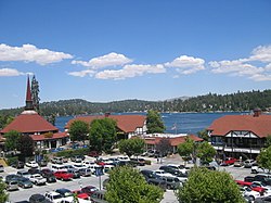
Lake Arrowhead Village, 1959.
As a scenic mountain resort in the San Bernardino Mountains, Lake Arrowhead's economy is almost completely supported by tourism, both by casual vacationers and part-time residents. The primary tourism industries include real estate, lodging, dining, recreation, and retail sales.
While Lake Arrowhead has no official town center, the Lake Arrowhead Village serves as the main commercial area for both locals and tourists and includes a number of factory outlets, boutiques, restaurants, two banks, a post office and a supermarket. One author visiting in 1978 described it as a "clean, Swiss-like community with many chalets."[6] Lake Arrowhead Village also hosts events all year long including a free Summer Concert Series, the county's largest free Oktoberfest and many other themed events such as car shows, dog shows, the Tour de Lake Arrowhead, Home Expo, and the popular Antique Wooden Boat Show.
Logging in the San Bernardino Mountains was once done on a large scale, with the Brookings Lumber Company operation one of the largest. It operated on 8,000 acres (32km2) between Fredalba and Hunsaker Flats (present-day Running Springs), between 1899 and 1912. It built a logging railroad to bring logs to the mill at Fredalba. The Shay locomotives had to be disassembled and hauled by wagon up the mountain, since the railroad operated in the high country but did not connect to other railroads in lowlands. Finished lumber was hauled by wagon down the steep grades to the Molino Box Factory in Highland, California.[8][9][10][11]
History
The area now known as Lake Arrowhead was originally called Little Bear Valley. In the late 1800s, developers began damming Little Bear Creek to create a reservoir for irrigation and hydroelectric use. By 1904, the Arrowhead Reservoir Company had taken over the project, but in 1913, a landmark court decision prohibited the diversion of water across watershed boundaries,[12] halting further irrigation plans.
In 1920, a Los Angeles-based group purchased the lake and surrounding land, forming the Arrowhead Lake Company. Between 1921 and 1923, they built a Norman-style resort village that included a pavilion, outdoor theater, dance hall, golf course, beach, and hotel. The development officially opened in June 1922[13] and began attracting tourists and second-home buyers from Southern California.[14]
Lake Arrowhead continued evolving as a resort destination through the mid-20th century, frequented by Hollywood celebrities and wealthy families. In 1960, businessman Jules Berman and partners acquired the lake property, launching new development through the Lake Arrowhead Development Company. By the late 1960s, the area was acquired by Boise Cascade, which subdivided large portions for residential sales before exiting in the early 1970s.[15]
Today, much of Lake Arrowhead’s infrastructure—roads, water, and sewer systems—is managed by the Lake Arrowhead Community Services District (LACSD), which was formed in 1978 after the dissolution of prior private utilities.
Legal challenges
Lake Arrowhead has faced multiple legal disputes related to land use, water rights, and environmental impacts.
Water Rights dispute with LACSD
In 2003, local property owners petitioned the California State Water Resources Control Board, arguing that the Lake Arrowhead Community Services District (LACSD) was withdrawing water from the lake without proper rights. In 2005, the Board ruled against LACSD, imposing fines and requiring the district to secure alternative water rights. A legal settlement was reached in 2006, allowing continued water use under regulated conditions.[16]
Additional challenges emerged in 2005 when conservation groups sued over county approval of large housing developments, alleging violations of California environmental law. The project was ultimately halted in court.[17]
Short-term rental (STR) access lawsuit
In 2020, the Arrowhead Lake Association (ALA) amended its bylaws to restrict lake and reserve-strip access for short-term renters—those staying less than 30 days. In response, a group of property owners organized as Vertical Web Ventures, sued ALA in San Bernardino County Superior Court in July 2022, alleging the change violated a 1964 agreement[18] that guarantees access to owners and their lessees (including short-term renters).
By January 2022, Judge Gilbert Ochoa issued a preliminary injunction reinstating lake access for qualifying short-term renters and non-member property owners,[19] finding they were likely to prevail in proving that ALA had overextended its authority under the 1964 agreement.
When the Superior Court injunction took effect, ALA issued new access rules allowing short-term renters to use the lake and tracks, provided they were listed on an ALA member’s permit and held an RFID card.
Following the injunction, the lawsuit was resolved through a settlement.[20] Under the agreement, ALA:
Revised its bylaws to allow short-term renters and non-member owners access to the lake when listed on a valid ALA permit;[21]
Agreed not to enforce Section C of its bylaws, which had previously banned those renters;
Confirmed that compliance with the 1964 Agreement governs future access rules.
Although the detailed settlement terms were not publicly available in full, this resolution reinforced Vertical Web Ventures’ central argument—that ALA had overstepped by applying its bylaws inconsistently with the surface access rights guaranteed by the 1964 Agreement.
Arrowhead Water/Blue Triton lawsuit
Lake Arrowhead has also been cited in regulatory disputes surrounding bottled water. In 2023, state agencies intervened in spring water withdrawals used by Arrowhead-branded bottled water, citing environmental concerns. A 2025 court ruling later allowed some of those operations to resume.[22]
PFAS contamination lawsuit
In 2025, class-action lawsuits were filed regarding PFAS contamination in the area’s drinking water. While local agencies maintained water safety, residents alleged exposure to harmful chemicals and sought damages.[23]
Geography
Lake Arrowhead weekend cabin designed by MGM film star Ruth Hussey
Lake Arrowhead is located in the Inland Empire region of Southern California, about 20 minutes north of the San Bernardino city limits. Its economic center is at the intersection of State Routes 173 and 189. The CDP has a total area of 19.0 square miles (49.1km2), of which 17.7 square miles (45.9km2) is land and 1.2 square miles (3.2km2; 6.46%) is water.
Lake Arrowhead is a private lake governed by the Arrowhead Lake Association and is for restricted use by Lake Arrowhead property owners.
Outside of Lake Arrowhead Village there are several residential communities, which include Cedar Glen, Blue Jay, Rimforest, Skyforest, Twin Peaks, Crest Park, Hook Creek Tract, Deer Lodge Park, Arrowhead Villas, Grass Valley, and Agua Fria. There are three elementary schools, one middle school, and one high school in the area.[25]7 miles (11km) north of Lake Arrowhead is the Pacific Crest Trail.
Santa's Village at Lake Arrowhead was a popular theme park from 1955 to 1998, and reopened in 2016. It was the first franchised one in the United States, with two others in the Santa Cruz Mountains and Illinois.[26][27]
The census reported that 99.8% of the population lived in households and 20 people (0.2%) were institutionalized.[44]
There were 5,113 households, out of which 22.9% included children under the age of 18, 53.0% were married-couple households, 4.9% were cohabiting couple households, 22.1% had a female householder with no partner present, and 20.0% had a male householder with no partner present. 26.9% of households were one person, and 13.0% were one person aged 65 or older. The average household size was 2.42.[44] There were 3,447 families (67.4% of all households).[45]
The age distribution was 19.0% under the age of 18, 6.6% aged 18 to 24, 20.2% aged 25 to 44, 29.2% aged 45 to 64, and 25.0% who were 65years of age or older. The median age was 49.3years. For every 100 females, there were 101.3 males.[44]
There were 11,737 housing units at an average density of 663.9 unitsper square mile (256.3 units/km2), of which 5,113 (43.6%) were occupied. Of these, 77.3% were owner-occupied, and 22.7% were occupied by renters.[44]
In 2023, the US Census Bureau estimated that 12.7% of the population were foreign-born. Of all people aged 5 or older, 75.0% spoke only English at home, 17.6% spoke Spanish, 3.5% spoke other Indo-European languages, 2.5% spoke Asian or Pacific Islander languages, and 1.4% spoke other languages. Of those aged 25 or older, 95.6% were high school graduates and 36.3% had a bachelor's degree.[46]
The median household income in 2023 was $88,147, and the per capita income was $52,386. About 5.6% of families and 11.9% of the population were below the poverty line.[47]
2010
At the 2010 census Lake Arrowhead had a population of 12,424. The population density was 655.6 inhabitants per square mile (253.1/km2). The racial makeup of Lake Arrowhead was 10,729 (86.4%) White (73.0% Non-Hispanic White),[48] 95 (0.8%) African American, 93 (0.7%) Native American, 152 (1.2%) Asian, 33 (0.3%) Pacific Islander, 847 (6.8%) from other races, and 475 (3.8%) from two or more races. Hispanic or Latino of any race were 2,709 persons (21.8%).[49]
The census reported that 12,389 people (99.7% of the population) lived in households, 16 (0.1%) lived in non-institutionalized group quarters, and 19 (0.2%) were institutionalized.
There were 4,672 households, 1,563 (33.5%) had children under the age of 18 living in them, 2,746 (58.8%) were opposite-sex married couples living together, 413 (8.8%) had a female householder with no husband present, 258 (5.5%) had a male householder with no wife present. There were 217 (4.6%) unmarried opposite-sex partnerships, and 64 (1.4%) same-sex married couples or partnerships. 984 households (21.1%) were one person and 358 (7.7%) had someone living alone who was 65 or older. The average household size was 2.65. There were 3,417 families (73.1% of households); the average family size was 3.07.
The age distribution was 3,043 people (24.5%) under the age of 18, 968 people (7.8%) aged 18 to 24, 2,571 people (20.7%) aged 25 to 44, 4,104 people (33.0%) aged 45 to 64, and 1,738 people (14.0%) who were 65 or older. The median age was 43.0 years. For every 100 females, there were 103.8 males. For every 100 females age 18 and over, there were 103.4 males.
There were 11,875 housing units at an average density of 626.6 per square mile, of the occupied units 3,428 (73.4%) were owner-occupied and 1,244 (26.6%) were rented. The homeowner vacancy rate was 7.9%; the rental vacancy rate was 12.4%. 8,647 people (69.6% of the population) lived in owner-occupied housing units and 3,742 people (30.1%) lived in rental housing units.
According to the 2010 United States Census, Lake Arrowhead had a median household income of $57,672, with 11.2% of the population living below the federal poverty line.[48]
The Arrowhead Woods Architectural Committee (AWAC) is a nonprofit organization responsible for enforcing the Covenants, Conditions, and Restrictions (CC&Rs) within the Arrowhead Woods residential tracts of Lake Arrowhead. Established in the early 1920s, AWAC’s role includes maintaining architectural design standards, regulating tree removal, and preserving the area's forested aesthetic.[53]
AWAC is incorporated as a California non-profit (EIN 33‑0208452) and operates under recorded CC&Rs and court authority.[54] In 2015, the San Bernardino County Superior Court confirmed AWAC as the legal successor-in-interest to enforce the CC&Rs, affirming their proper renewal.[55] The committee collects fees and penalties from property owners for non-compliance or proposed property modifications.
In 2022, the California Legislature passed Senate Bill 1405, authorizing the Lake Arrowhead Community Services District (LACSD) to assume AWAC's responsibilities under specific conditions, including a property owner petition, public hearings, LAFCO approval, and adoption of an ordinance.[56] However, the transfer was never completed. AWAC; under extreme pressure from the community, later advocated for repeal of SB 1405, and LACSD did not assume any enforcement duties. As of 2025, AWAC continues to independently enforce the CC&Rs.
AWAC is currently managing the 2025 CC&R renewal process internally. Ballots are not being counted by any third-party; instead, AWAC is handling the vote privately—“for privacy reasons the ballots will not be made public but only each individual voter may see his or her ballots”—without external audit or oversight.[57]
Climate
The Lake Arrowhead Community has a unique climate for Southern California with four distinct seasons which support an array of outdoor recreational activity and year-round beauty. Lake Arrowhead has a Warm-summer Mediterranean climate (Köppen climate classificationCsb). During the summer, warm temperatures and monsoon thunderstorms are common. During the winter months, large Pacific storms bring plenty of snow. The area receives about 300 annual days of sunshine per year. Beginning in late 2011, a catastrophic drought began affecting Lake Arrowhead along with the rest of California. By November 2016, the lake level dropped 11.975 feet (3.650m). This drop exposed much of the lake floor and beached most of the docks.[58] As of February 2019, the lake has rebounded to just 2 feet (0.61m) below the historical average.
Climate data for Lake Arrowhead, California, 1991–2020 normals, extremes 1941–2010
Heavy snow and winds have caused major power outages in the area. A storm in the last week of December 2021 left many homes without power for a week.[61] Similarly on Thanksgiving weekend 2019, homes were without power for up to four days.[62]
Of special note, the exterior shots for the movie Sunrise: A Song of Two Humans (1927) were filmed here.[64] The film won three Academy Awards at the very first Academy Awards ceremony in 1929.[64]
In addition, the Lake Arrowhead Conference Center (or a set made to look like it) was the setting for the TV series Dragnet, Season 3, Episode 13 of the 1960s re-boot, where Friday and Gannon attend a conference for Los Angeles Police Department officers to discuss problems and solutions.
The Lake Arrowhead Communities have numerous cultural events and organizations. The Arrowhead Arts Association is a non-profit corporation dedicated to cultural enrichment sponsoring quality musical performances and providing musical education and scholarships for local youth from preschool through college. The Mountain Skies Astronomical Society is also located there.
Located approximately 80 miles (130km) from downtown Los Angeles, many Hollywood stars and wealthy Angelinos built homes in the area starting in the 1920s and 30s.[66] These homes and estates were designed by some of the most significant architects practicing in Southern California at the time. These architects included:
In the early years of development, the architectural committee of the resort community mandated that homes be built in the French Norman or English Tudor Style. Rudolf Schindler, a modernist architect, designed what is known as the first modern A-frame house in 1936 for Gisela Bennati, as his interpretation of French Norman style architecture. The first known sketches for the Bennati Cabin date from 1934.[69] Schindler did sketches for "triangle-based house designs" as early as 1922, but none of those designs were built.[70] Lake Arrowhead is also home to what has been sometimes referred to as the world’s largest A-frame structure, the clubhouse of the Lake Arrowhead Country Club.
↑"Listing of Dams". California Department of Water Resources, Division of Dam Safety. Archived from the original on April 30, 2007. Retrieved February 21, 2007.
↑Bilanchone, Catherine M. (2006), "Van Nuys, Isaac Newton (1835–1912)", Encyclopedia of Immigration and Migration in the American West, SAGE Publications, Inc., doi:10.4135/9781412952439.n299, ISBN9781412905503
This page is based on this Wikipedia article Text is available under the CC BY-SA 4.0 license; additional terms may apply. Images, videos and audio are available under their respective licenses.