San Antonio Heights, California

Last updated

San Antonio Heights
San Bernardino County California Incorporated and Unincorporated areas San Antonio Heights Highlighted.svg
Location in San Bernardino County and the state of California
Usa edcp location map.svg
Red pog.svg
San Antonio Heights
Location in the United States
Coordinates: 34°09′20″N117°39′23″W / 34.15556°N 117.65639°W / 34.15556; -117.65639 [1]
Country Flag of the United States.svg  United States
State Flag of California.svg  California
County San Bernardino
Area
[2]
  Total2.619 sq mi (6.781 km2)
  Land2.458 sq mi (6.365 km2)
  Water0.162 sq mi (0.416 km2)  6.13%
Elevation
[1]
2,103 ft (641 m)
Population
 (2010)
  Total3,371
  Density1,300/sq mi (500/km2)
Time zone UTC-8 (PST)
  Summer (DST) UTC-7 (PDT)
ZIP code
91784
Area code 909
FIPS code 06-64462
GNIS feature IDs 1661373, 2409248

San Antonio Heights is a census-designated place (CDP) in the San Bernardino County, California. It is in the northern Pomona Valley and the foothills of the San Gabriel Mountains. The population was 3,371 at the 2010 census, up from 3,122 at the 2000 census.

Contents

Geography

San Antonio Heights is an area located at 34°9′11″N117°39′41″W / 34.15306°N 117.66139°W / 34.15306; -117.66139 (34.153008, -117.661433). [3] The area is north of the city of Upland.

According to the United States Census Bureau, the CDP has a total area of 2.6 square miles (6.7 km2). 2.5 square miles (6.5 km2) of it is land and 0.2 square miles (0.52 km2) of it (6.13%) is water.

Climate

This region experiences hot, dry summers and mild, rainy winters, receiving more rainfall than most areas in Metro Los Angeles due to being situated in the upslope foothill regions and experiencing orographic effects which increase precipitation. According to the Köppen Climate Classification system, San Antonio Heights has a hot-summer Mediterranean climate, abbreviated "Csa" on climate maps.

Climate data for San Antonio Canyon, California (1917-1967 averages)
MonthJanFebMarAprMayJunJulAugSepOctNovDecYear
Average high °F (°C)61.9
(16.6)
63.8
(17.7)
66.4
(19.1)
70.7
(21.5)
75.0
(23.9)
82.0
(27.8)
91.6
(33.1)
91.6
(33.1)
88.8
(31.6)
79.9
(26.6)
71.2
(21.8)
65.1
(18.4)
75.7
(24.3)
Average low °F (°C)41.7
(5.4)
42.2
(5.7)
43.1
(6.2)
46.1
(7.8)
49.0
(9.4)
53.5
(11.9)
61.3
(16.3)
61.8
(16.6)
60.8
(16.0)
54.8
(12.7)
48.5
(9.2)
44.7
(7.1)
50.6
(10.4)
Average precipitation inches (mm)4.36
(111)
4.52
(115)
4.00
(102)
2.76
(70)
0.77
(20)
0.11
(2.8)
0.03
(0.76)
0.07
(1.8)
0.45
(11)
1.07
(27)
2.59
(66)
4.35
(110)
25.08
(637.36)
Average snowfall inches (cm)0.7
(1.8)
0.0
(0.0)
0.0
(0.0)
0.0
(0.0)
0.0
(0.0)
0.0
(0.0)
0.0
(0.0)
0.0
(0.0)
0.0
(0.0)
0.0
(0.0)
0.0
(0.0)
0.1
(0.25)
0.8
(2.05)
Source: [4]

Demographics

2010

The 2010 United States Census [5] reported that San Antonio Heights had a population of 3,371. The population density was 1,287.6 inhabitants per square mile (497.1/km2). The racial makeup of San Antonio Heights was 2,765 (82.0%) White (69.3% Non-Hispanic White), [6] 67 (2.0%) African American, 24 (0.7%) Native American, 284 (8.4%) Asian, 15 (0.4%) Pacific Islander, 115 (3.4%) from other races, and 101 (3.0%) from two or more races. Hispanic or Latino of any race were 612 persons (18.2%).

The Census reported that 3,358 people (99.6% of the population) lived in households, 13 (0.4%) lived in non-institutionalized group quarters, and 0 (0%) were institutionalized.

There were 1,198 households, out of which 390 (32.6%) had children under the age of 18 living in them, 786 (65.6%) were opposite-sex married couples living together, 94 (7.8%) had a female householder with no husband present, 75 (6.3%) had a male householder with no wife present. There were 53 (4.4%) unmarried opposite-sex partnerships, and 17 (1.4%) same-sex married couples or partnerships. 175 households (14.6%) were made up of individuals, and 88 (7.3%) had someone living alone who was 65 years of age or older. The average household size was 2.80. There were 955 families (79.7% of all households); the average family size was 3.08.

The population was spread out, with 700 people (20.8%) under the age of 18, 281 people (8.3%) aged 18 to 24, 639 people (19.0%) aged 25 to 44, 1,182 people (35.1%) aged 45 to 64, and 569 people (16.9%) who were 65 years of age or older. The median age was 46.3 years. For every 100 females, there were 101.1 males. For every 100 females age 18 and over, there were 102.2 males.

There were 1,239 housing units at an average density of 473.3 per square mile (182.7/km2), of which 1,004 (83.8%) were owner-occupied, and 194 (16.2%) were occupied by renters. The homeowner vacancy rate was 0.8%; the rental vacancy rate was 5.4%. 2,851 people (84.6% of the population) lived in owner-occupied housing units and 507 people (15.0%) lived in rental housing units.

According to the 2010 United States Census, San Antonio Heights had a median household income of $106,905, with 2.9% of the population living below the federal poverty line. [6]

2000

As of the census [6] of 2000, there were 3,122 people, 1,081 households, and 891 families residing in the CDP. The population density was 2,228.7 inhabitants per square mile (860.5/km2). There were 1,121 housing units at an average density of 800.3 per square mile (309.0/km2). The racial makeup of the CDP was 85.4% White, 1.4% African American, 0.7% Native American, 6.1% Asian, <0.1% Pacific Islander, 3.1% from other races, and 3.3% from two or more races. Hispanic or Latino of any race were 10.5% of the population.

There were 1,081 households, out of which 35.0% had children under the age of 18 living with them, 70.3% were married couples living together, 8.0% had a female householder with no husband present, and 17.5% were non-families. 12.6% of all households were made up of individuals, and 5.4% had someone living alone who was 65 years of age or older. The average household size was 2.9 and the average family size was 3.1.

In the CDP, the population was spread out, with 24.4% under the age of 18, 7.3% from 18 to 24, 24.1% from 25 to 44, 29.5% from 45 to 64, and 14.6% who were 65 years of age or older. The median age was 42 years. For every 100 females, there were 94.5 males. For every 100 females age 18 and over, there were 95.8 males.

The median income for a household in the CDP was $75,557, and the median income for a family was $80,975. Males had a median income of $56,576 versus $30,929 for females. The per capita income for the CDP was $36,267. About 4.8% of families and 6.9% of the population were below the poverty line, including 8.1% of those under age 18 and 0.4% of those age 65 or over.

Public safety

Law enforcement is provided by the San Bernardino County Sheriff's Department. Fire, rescue, and EMS is provided by the San Bernardino County Fire Department. American Medical Response provides additional EMS and patient transportation.

Star house and Community

Beginning in 1958, a private residence directly north of Euclid Avenue in San Antonio Heights displayed an enormous five-point star of lights each holiday season. [7] Traditionally the 35-foot star was lit each night between Thanksgiving and New Year's Day and was visible for miles throughout the Pomona Valley.

The star and the two-story home to which it was attached were destroyed October 25, 2003 in the Grand Prix Fire that swept through the area. More than $20,000 was raised to assist the property owner in rebuilding the star, so a temporary replacement measuring 65 feet tall was erected with a crane during the 2003-2005 holiday seasons. The star was not lit in 2006 after its copper wiring was stolen from the site. Because of this, hundreds of residents of San Antonio Heights purchased smaller stars that year and put those on their houses during the holiday season. It's a tradition that has continued.

Ken Petschow, a commercial airline pilot who owns the property, lit the star again beginning in 2007.

The community holds three annual events: A pancake breakfast on the weekend preceding Memorial Day, a Steakfest in mid-September—both at San Antonio Park—and a Holiday Sing-Along on Christmas Eve at Local Fire Station 12.

Government

In the California State Legislature, San Antonio Heights is in the 25th Senate District , represented by Democrat Anthony Portantino, and in the 41st Assembly District , represented by Democrat Chris Holden. [8]

In the United States House of Representatives, San Antonio Heights is in California's 27th congressional district , represented by Republican Mike Garcia. [9]

The unincorporated community is in San Bernardino County's Second District and is overseen by the county. A homeowners' group, San Antonio Heights Association, advocates for various issues related to the Heights community.

Related Research Articles

<span class="mw-page-title-main">Desert Hills, Arizona</span> CDP in Mohave County, Arizona

Desert Hills is an unincorporated community and census-designated place (CDP) in Mohave County, Arizona, United States. The population was 2,764 at the 2020 census, up from 2,245 at the 2010 census.

<span class="mw-page-title-main">Willow Valley, Arizona</span> Census-designated place in Arizona, United States

Willow Valley is an unincorporated community and census-designated place (CDP) in Mohave County, Arizona, United States. The population was 1,059 as of the 2020 census.

<span class="mw-page-title-main">East Richmond Heights, California</span> Unincorporated community in California, United States

East Richmond Heights is an unincorporated community and census-designated place (CDP) in western Contra Costa County, California, United States. Its population was 3,280 at the 2010 census.

<span class="mw-page-title-main">South San Gabriel, California</span> Census-designated place in California, United States

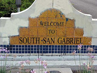
South San Gabriel is a census-designated place (CDP) in Los Angeles County, California, United States. The population was 8,070 at the 2010 census, up from 7,595 at the 2000 census.

<span class="mw-page-title-main">San Ardo, California</span> Unincorporated community in California, United States

San Ardo, formerly known as San Bernardo, is an unincorporated community and census-designated place (CDP) in Monterey County, California, United States. San Ardo is located 18 miles (29 km) southeast of King City at an elevation of 449 feet (137 m). The population was 392 at the 2020 census, down from 517 in 2010.

<span class="mw-page-title-main">Bloomington, California</span> Place in California, United States

Bloomington is a unincorporated community in San Bernardino County, California, United States. The population was 23,851 at the 2010 census, up from 19,318 at the 2000 census. For statistical purposes, the United States Census Bureau has defined Bloomington as a census-designated place (CDP).

<span class="mw-page-title-main">Bluewater, California</span> Census-designated place in California, United States

Bluewater is a census-designated place (CDP) in San Bernardino County, California, United States. The population was 172 at the 2010 census, down from 265 at the 2000 census.

<span class="mw-page-title-main">Mentone, California</span> Census-designated place in California, United States

Mentone is a census-designated place in San Bernardino County, California, United States. The population was 7,803 at the 2000 census and 8,720 at the 2010 census. It is located at 34°3′53″N117°7′13″W.

<span class="mw-page-title-main">Muscoy, California</span> Census-designated place in California, United States

Muscoy is a census-designated place (CDP) in San Bernardino County, California, United States. The population was 10,644 at the 2010 census, up from 8,919 at the 2000 census. Muscoy shares ZIP code 92407 with the communities of Verdemont, Devore Heights, Rosena Ranch and Arrowhead Farms in northwestern San Bernardino. Residents enjoy a semi-rural setting with large lots where they can raise horses and other livestock, nursery plants, and fruit trees. For this reason, much of Muscoy is included in the county Additional Agriculture (AA) overlay, which specifies the types and quantities of animals that may be kept on each parcel. A distinctive feature of Muscoy life today is motor vehicles and equestrians sharing the roadways.

Lake Arrowhead is a census-designated place (CDP) in the towns of Waterboro and Limerick in York County, Maine, United States. The population was 3,071 at the 2010 census. The CDP corresponds to the area covered by the Lake Arrowhead Community, a large subdivision begun in the 1960s which surrounds Lake Arrowhead, an artificial lake on the Little Ossipee River. The community is part of the Portland–South Portland–Biddeford, Maine Metropolitan Statistical Area.

<span class="mw-page-title-main">Holiday Heights, New Jersey</span> Census-designated place in New Jersey, United States

Holiday Heights is an unincorporated community and census-designated place (CDP) located within Berkeley Township, in Ocean County, in the U.S. state of New Jersey. As of the 2010 United States Census, the CDP's population was 2,099.

<span class="mw-page-title-main">Crown Heights, New York</span> Census-designated place in New York, United States

Crown Heights is a hamlet and census-designated place (CDP) in Dutchess County, New York, United States. The population was 2,840 at the 2010 census. It is part of the Poughkeepsie–Newburgh–Middletown, NY Metropolitan Statistical Area as well as the larger New York–Newark–Bridgeport, NY-NJ-CT-PA Combined Statistical Area.

<span class="mw-page-title-main">Washington Heights, New York</span> CDP in New York, United States

Washington Heights is a census-designated place (CDP) in Orange County, New York, United States. The population was 2,205 at the 2020 census.

<span class="mw-page-title-main">Lenape Heights, Pennsylvania</span> Census-designated place in Pennsylvania, United States

Lenape Heights is a census-designated place (CDP) in Armstrong County, Pennsylvania, United States. The population was 1,167 at the 2010 census.

Arlington Heights is a census-designated place (CDP) in Monroe County, Pennsylvania, United States. The population was 6,331 at the 2020 census. One notable location in Arlington Heights is the Stroud Mall.

<span class="mw-page-title-main">Shenandoah Heights, Pennsylvania</span> CDP in Pennsylvania, United States

Shenandoah Heights is a census-designated place (CDP) in Schuylkill County, Pennsylvania. The population was 1,298 at the 2000 census.

Woodland Heights is a census-designated place (CDP) in Venango County, Pennsylvania, United States. The population was 1,402 at the 2000 census.

Lawson Heights is a census-designated place (CDP) in Unity Township, Westmoreland County, Pennsylvania, United States. The population was 2,339 at the 2000 census.

<span class="mw-page-title-main">Scenic Oaks, Texas</span> Census-designated place in Texas, United States

Scenic Oaks is a census-designated place (CDP) in Bexar County, Texas, United States. It is part of the San Antonio Metropolitan Statistical Area. The population was 10,458 at the 2010 census, up from 4,957 at the 2010 census.

<span class="mw-page-title-main">Laguna Heights, Texas</span> Census-designated place in Texas, United States

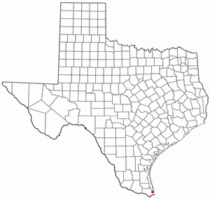
Laguna Heights is a census-designated place (CDP) in Cameron County, Texas, United States. The population was 3,488 at the 2010 census.

References

  1. 1 2 "San Antonio Heights". Geographic Names Information System . United States Geological Survey, United States Department of the Interior . Retrieved November 18, 2014.
  2. "2010 Census U.S. Gazetteer Files – Places – California". United States Census Bureau.
  3. "US Gazetteer files: 2010, 2000, and 1990". United States Census Bureau. February 12, 2011. Retrieved April 23, 2011.
  4. "Western Regional Climate Center" . Retrieved March 21, 2022.
  5. "2010 Census Interactive Population Search: CA - San Antonio Heights CDP". U.S. Census Bureau. Archived from the original on July 15, 2014. Retrieved July 12, 2014.
  6. 1 2 3 "U.S. Census Bureau". www.census.gov. United States Census Bureau. Archived from the original on January 31, 2008. Retrieved June 10, 2023.
  7. DiMartino, Mediha Fejzagic: "Star kept shining for 50 years Archived 2011-09-29 at the Wayback Machine ", The Sun, 27 November 2008
  8. "Statewide Database". UC Regents. Archived from the original on February 1, 2015. Retrieved December 8, 2014.
  9. "California's 27th Congressional District - Representatives & District Map". Civic Impulse, LLC.