
Matabeleland North is a province in western Zimbabwe. With a population of 827,645 as of the 2022 census, it is the country's second-least populous province, after Matabeleland South, and the least densely Zimbabwean populated province. Matabeleland North and Matabeleland South were established in 1974, when the original Matabeleland Province was bifurcated, eventually losing territory in 1997 when the city of Bulawayo became a province in its own right. Matabeleland North is divided into seven districts, has its capital in Lupane, and Victoria Falls and Hwange its largest towns. The name "Matabeleland" is derived from the Matabele or Ndebele people, the province's largest ethnic group.
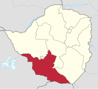
Matabeleland South is a province in southwestern Zimbabwe. With a population of 683,893 as of the 2012 Zimbabwean census. It is the country's least populated province after Matabeleland North.Matabeleland South and Matabeleland North were established in 1974, when the original Matabeleland Province was bifurcated. The province is divided into six districts. Gwanda is the capital, and Beitbridge is the province's largest town. The name "Matabeleland" is derived from Ndebele, the province's largest ethnic group.

Francistown is the second-largest city in Botswana, with a population of about 103,417 and 147,122 inhabitants for its agglomeration at the 2022 census. It is located in eastern Botswana, about 400 kilometres (250 mi) north-northeast from the capital, Gaborone. Francistown is located at the confluence of the Tati and Ntshe rivers, and near the Shashe River and 90 kilometres (56 mi) from the international border with Zimbabwe.

Beitbridge is a border town in the province of Matabeleland South, Zimbabwe. The name also refers to the border post and bridge spanning the Limpopo River, which forms the political border between South Africa and Zimbabwe. The border on the South African side of the river is also named Beitbridge.

Gwanda is a town in Zimbabwe. It is the capital of the province of Matabeleland South, one of the ten administrative provinces in the country. It is also the district capital of Gwanda District, one of the seven administrative districts in the province.
Esigodini, originally known as Essexvale, is a town in the Matabeleland South Province of Zimbabwe. It is the administrative centre for Umzingwane District, one of the seven administrative districts in Matabeleland South. It was originally an estate of Frederick Selous, a British explorer, officer, professional hunter, and conservationist.

The North-East District is one of the administrative districts of Botswana. Its capital is Francistown. In 2011, North-East had a population of 60,264 people. The district is predominantly occupied by Kalanga-speaking people, the BaKalanga. The district is administered by a district administration and district council, which are responsible for local administration.

Central is the largest of Botswana's districts in terms of area and population. It encompasses the traditional homeland of the Bamangwato people. Some of the most politically connected Batswana have come from the Central District, including former President Sir Seretse Khama, former President Festus Mogae, and former President Lt. General Seretse Ian Khama. The district borders the Botswanan districts of Chobe in the north, North-West in the northwest, Ghanzi in the west, Kweneng in southwest, Kgatleng in the south and North-East in the northeast, as well as Zimbabwe also in the northeast and South Africa in the southeast.
Figtree is a village in the province of Matabeleland South, Zimbabwe. It is located about 37 km south-west of Bulawayo on the main Bulawayo-Plumtree road. The village is named after a wild fig tree which in the 19th century those wishing to enter the Matabele Kingdom had to wait by this tree for permission to proceed. The one and the only tollgate of Bulawayo-Plumtree highway is located in Figtree and after this tollgate towards Plumtree there is Figtree business center, about 100m off the main road to the west. About 4 km from Figtree there is a Bazha turn, unpaved road which connects to Matopo-Kezi-Maphisa road. Francistown(Botswana) is a major town located close to Figtree and is 155 km away from Francistown.
Ramokgwebana is a village in the North-East District of Botswana, close to the eastern border, which is defined by the Ramokgwebana River. Plumtree, Zimbabwe is on the other side of the border crossing.

Filabusi is a town in the Matabeleland South Province of Zimbabwe. The town is the administrative capital of Insiza District and a service centre for the surrounding mining and farming areas.
Brunapeg is a settlement in the Matabeleland South Province of Zimbabwe. It is one of the urban centres in Mangwe District, one of the seven administrative districts in the province.
List of Railway stations in Botswana include:
The Kalanga or BaKalanga are a southern Bantu ethnic group mainly inhabiting Matebeleland in Zimbabwe, northern Botswana, and parts of the Limpopo Province in South Africa.

The Cairo–Cape Town Highway is Trans-African Highway 4 in the transcontinental road network being developed by the United Nations Economic Commission for Africa (UNECA), the African Development Bank (AfDB), and the African Union. The route has a length of 10,228 km (6,355 mi) and links Cairo in Egypt to Cape Town in South Africa.

Bulilimamangwe District was a former district in Zimbabwe. In 2003 it was subdivided into three districts: Bulilima District, Mangwe District and Plumtree Town. At the time of its dissolution the area had a population of just under 300,000.
A7 Road is a national road in Zimbabwe that connects Bulawayo with the Plumtree Border Post with Botswana. It is popularly known as the Bulawayo-Plumtree Road. The A7 is part of Trans-Africa Highway 4. It is one of the two routes that form the R2 Route, which connects the Plumtree Border with Harare.
Ndingo Johwa is a Motswana trumpeter, flugelhornist, cornetist, Guitarist, composer and singer. He is known for his jazz compositions, as well as for writing the Phondanyama song. He is part of the Re Batswana Music Ensemble.
Mangwe District is a district of the Province Matabeleland South in Zimbabwe. It is divided into 17 wards. Some of the wards are Ngwizi, Mphoengs, Sanzukwi, Sangulube, Maninji, Madabe, Mbakwe, Empandeni, Mayobodo, Mambale, Makorokoro, Tshitshi, and Marula. Some villages found in this district are Bulu, Kweneng, Togotsweu. Mangwe used to be a part of bigger district which was known as Bulilimamangwe. Bulilimamangwe was then divided into 3 districts now known as Mangwe, Bulilima and Plumtree.
Zwenshambe is a village in the North-East District of Botswana. It is situated between Gungwe village in the west, Nlapkhwane village in the east, Mulambakwena village in the south and the Zimbabwe border in the north. It is not far from the Ramokgwebana Border Post. The nearest city to Zwenshambe is Francistown which is also the second largest city in Botswana.
