
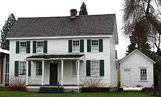
Oregon City is the county seat of Clackamas County, Oregon, United States, located on the Willamette River near the southern limits of the Portland metropolitan area. As of the 2020 census, the city population was 37,572. Established in 1829 by the Hudson's Bay Company, in 1844 it became the first U.S. city west of the Rocky Mountains to be incorporated.

Clackamas County is one of the 36 counties in the U.S. state of Oregon. As of the 2020 census, the population was 421,401, making it Oregon's third-most populous county. Its county seat is Oregon City. The county was named after the American Indians living in the area, the Clackamas people, who are part of the Chinookan peoples.

Estacada is a city in Clackamas County, Oregon, United States, about 30 miles (48 km) southeast of Portland. The 2020 population is estimated to be 3,700. According to the 2010 census, the population in 2010 was 2,695.
Molalla is a city in Clackamas County, Oregon. The population was 10,228 at the time of the 2020 census.

Oak Grove is an unincorporated community in Clackamas County, Oregon, United States, in the Portland metropolitan area. For statistical purposes, the United States Census Bureau has defined Oak Grove as a census-designated place (CDP). The census definition of the area may not precisely correspond to local understanding of the area with the same name. The population was 16,629 at the 2010 census.

Wilsonville is a city primarily in Clackamas County, Oregon, United States. A portion of the northern section of the city is in Washington County. It was founded as Boones Landing because of the Boones Ferry which crossed the Willamette River at the location; the community became Wilsonville in 1880. The city was incorporated in 1969 with a population of approximately 1,000. The population was 13,991 at the 2000 census, and grew to 19,509 as of 2010. Slightly more than 90% of residents at the 2000 census were white, with Hispanics comprising the largest minority group.

The Clackamas River is an approximately 83-mile (134 km) tributary of the Willamette River in northwestern Oregon, in the United States. Draining an area of about 940 square miles (2,435 km2), the Clackamas flows through mostly forested and rugged mountainous terrain in its upper reaches, and passes agricultural and urban areas in its lower third. The river rises in eastern Marion County, about 55 miles (89 km) east-southeast of Salem. The headwaters are on the slopes of Olallie Butte in the Mount Hood National Forest, about 10 miles (16 km) north of Mount Jefferson, at an elevation of 4,909 feet (1,496 m) in the Cascade Range. The Clackamas flows briefly north and then flows northwest through the mountains, passing through North Fork Reservoir and Estacada. It then emerges from the mountains southeast of Portland. It joins the Willamette near Oregon City and forms the boundary between Oregon City and Gladstone.

Lolo Pass is a mountain pass 6 miles (10 km) northwest of Mount Hood and 10 miles (16 km) northeast of Zigzag, Oregon, on the Clackamas–Hood River county line. It divides the Sandy River watershed on the southwest from the Hood River watershed on the northeast.

The Portland metropolitan area is a metro area with its core in the U.S. states of Oregon and Washington. It has 5 principal cities the largest being Portland, Oregon. The U.S. Office of Management and Budget (OMB) identifies it as the Portland–Vancouver–Hillsboro, OR–WA Metropolitan Statistical Area, a metropolitan statistical area used by the United States Census Bureau (USCB) and other entities. The OMB defines the area as comprising Clackamas, Columbia, Multnomah, Washington, and Yamhill Counties in Oregon, and Clark and Skamania Counties in Washington. The area had a population of 2,512,859 at the 2020 census, an increase of over 12% since 2010.

Oregon Route 224 is a state highway which runs through some of Portland's southeastern suburbs and ends in the Cascades.
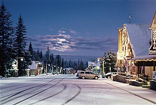
Government Camp is an unincorporated community and census-designated place located in Clackamas County, Oregon, United States, on the base of Mount Hood and north of Tom Dick and Harry Mountain. It is the only town within 5 miles (8 km) of Mount Hood and therefore is the de facto "mountain town" or "ski town". It is the gateway to several ski resorts, with the most popular being Timberline Lodge and Mount Hood Skibowl. Government Camp also has its own, smaller ski resort, Summit Pass.

Apiary is an unincorporated community in Columbia County, Oregon, United States, that takes its name from a post office established by David M. Dorsey. The post office operated from August 28, 1889, until March 24, 1924. It is reported that Dorsey was a beekeeper, which provided the source of the name for the Post Office and thus the community.
Oak Grove Fork Clackamas River is a 21-mile (34 km) tributary of the Clackamas River in the U.S. state of Oregon. From its headwaters in the Warm Springs Indian Reservation near Abbot Pass in the Cascade Range, the river flows generally west through Mount Hood National Forest in Clackamas County to the unincorporated community of Ripplebrook. Here it enters the main stem of the Clackamas River. Oak Grove Fork feeds Timothy Lake and Lake Harriet, two artificial impoundments built along its course to control water flows to hydroelectric plants.

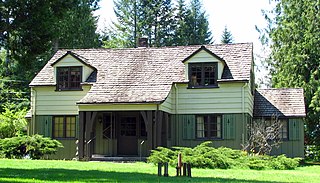
The Clackamas Lake Ranger Station Historic District is a Forest Service compound consisting of eleven historic buildings located in the Mount Hood National Forest in the Cascade Mountains of northern Oregon. It was originally built as a district ranger station for the Clackamas Lake Ranger District. It was later converted to a summer guard station. Today, the Forest Service rents the historic ranger's residence to recreational visitors. The Clackamas Lake Ranger Station is listed as a historic district on the National Register of Historic Places.

The Rand Ranger Station is a Bureau of Land Management compound consisting of eight historic buildings located in the Rogue River-Siskiyou National Forest in southwest Oregon. It was built by the United States Forest Service and the Civilian Conservation Corps as a district ranger station for the Galice Ranger District. The ranger station property was transferred to the Bureau of Land Management in 1970. Today, the ranger station office serves as a visitor center. The Rand Ranger Station is listed on the National Register of Historic Places.

The Allison Guard Station is a Forest Service compound consisting of eight rustic buildings located in the Malheur National Forest in the Ochoco Mountains of eastern Oregon. It was originally built as a district ranger station for the Snow Mountain Ranger District. It was later converted to a summer guard station. Today, it is an active Forest Service guard station with a crew of twelve fire fighters on station during the summer fire season. The station's oldest building, the Donnelly Cabin, is currently listed on the National Register of Historic Places as the "Allison Ranger Station". Most of the other buildings at the Allison Guard Station are eligible for historic designation, but are not yet listed on the National Register.
The Zigzag Ranger Station is a Forest Service compound consisting of twenty rustic buildings located in Oregon's Mount Hood National Forest. It was built as the administrative headquarters for the Zigzag Ranger District. It is located in the small unincorporated community of Zigzag, Oregon. Many of the historic buildings were constructed by the Civilian Conservation Corps between 1933 and 1942. Today, the Forest Service still uses the ranger station as the Zigzag Ranger District headquarters. The ranger station is listed on the National Register of Historic Places.

Cazadero is an unincorporated historic locale in Clackamas County, Oregon, United States. Cazadero was a station on the Estacada interurban railway line of the Portland Railway, Light and Power Company (PRL&P) and later Portland Electric Power Company (PEPCO), near where the power plant of the PEPCO-owned Cazadero Dam was located on the Clackamas River.

The Unity Ranger Station is a United States Forest Service compound consisting of five buildings and a lookout tower in the Wallowa-Whitman National Forest of northeastern Oregon. It was previously the administrative headquarters for the Unity Ranger District. It is located in the small unincorporated community of Unity, Oregon. The historic structures were built in the rustic style by the Civilian Conservation Corps between 1936 and 1938. Today, the ranger station is only used during the summer months to house Forest Service fire crews. The ranger station is listed on the National Register of Historic Places.

The Lake of the Woods Ranger Station is a United States Forest Service compound consisting of eight buildings overlooking Lake of the Woods in the Fremont-Winema National Forests of southern Oregon. All of the ranger station structures were built by the Civilian Conservation Corps between 1937 and 1939. Today, the compound serves as a Forest Service work center, and the old ranger station office is a visitor center. The ranger station is listed on the National Register of Historic Places.

