
Hobart is the capital and most populous city of the island state of Tasmania, Australia. Home to almost half of all Tasmanians, it is the southernmost and least-populated Australian state capital city, and second-smallest if territories are taken into account, before Darwin, Northern Territory. Hobart is located in Tasmania's south-east on the estuary of the River Derwent, making it the most southern of Australia's capital cities. Its skyline is dominated by the 1,271-metre (4,170 ft) kunanyi/Mount Wellington, and its harbour forms the second-deepest natural port in the world, with much of the city's waterfront consisting of reclaimed land. The metropolitan area is often referred to as Greater Hobart, to differentiate it from the City of Hobart, one of the seven local government areas that cover the city. It has a mild maritime climate.
Councils of Tasmania are the 29 administrative districts of the Australian state of Tasmania. Local government areas (LGAs), more generally known as councils, are the tier of government responsible for the management of local duties such as road maintenance, town planning and waste management.

Clarence City Council is a local government body in Tasmania, and one of the five municipalities that constitutes the Greater Hobart Area. The Clarence local government area has a population of 61,531, covering the eastern shore of the Derwent River from Otago to the South Arm Peninsula and the smaller localities of Cambridge, Richmond, and Seven Mile Beach.

Bellerive Oval is a cricket and an Australian rules football ground located in Bellerive, a suburb on the eastern shore of Hobart, Australia, holding 20,000 people it is the largest capacity stadium in Tasmania. It is the only venue in Tasmania which hosts international cricket matches.

The Tasman Highway is a highway in Tasmania, Australia. Like the Midland Highway, it connects the major cities of Hobart and Launceston – however it takes a different route, via the north-eastern and eastern coasts of the state. The Highway also acts as a major commuter road to Hobart residents living on the eastern side of the Derwent River. The designation "Tasman Highway" arises from its location facing the Tasman Sea – named, like the state itself, after Abel Tasman. The highway is one of the longest in Tasmania – 410 km (250 mi), with an average travelling time of 41⁄2 hours.

Bellerive is a suburb of the City of Clarence, part of the greater Hobart area, Tasmania, Australia. It stretches from Kangaroo Bay where it borders Rosny Park, around the curved shoreline of Bellerive Esplanade to Kangaroo Bluff, then down to Bellerive Beach and east to Second Bluff, where Bellerive borders Howrah. To the north Bellerive is bordered by the small foothills of Waverly Flora Park.

Rosny is a suburb of the City of Clarence, part of the greater Hobart area, Tasmania, Australia. It is located on the eastern shore of the Derwent River, between the suburbs of Montagu Bay and Rosny Park, approximately 4 kilometres from Hobart's centre. Rosny is the residential part of its commercial namesake Rosny Park.
Howrah is a residential locality in the local government area (LGA) of Clarence in the Hobart LGA region of Tasmania. The locality is about 5 kilometres (3.1 mi) south-east of the town of Rosny Park. The 2021 Census recorded a population of 9,545 for the state suburb of Howrah. It is a suburb of the City of Clarence. It is east of Bellerive and north of Tranmere.

Lindisfarne is a suburb of Hobart's Eastern Shore, located approximately 6 kilometres from the City Centre and is part of the municipal City of Clarence.

Rosny College is a government comprehensive senior secondary school located in Rosny Park, a suburb of Hobart, Tasmania, Australia. Established in 1973, the college caters for approximately 1,000 students in Years 11 and 12. The college is administered by the Tasmanian Department of Education.
Montagu Bay is a suburb of Hobart, Tasmania, located in the City of Clarence on the eastern shore of the Derwent River, about four kilometres from the city centre of greater Hobart. It is a small primarily residential suburb located between Rosny, Rose Bay and Lindisfarne and is centred on a small bay of the same name, formerly known as Smelting Works Bay. The bay has a boat ramp and jetty, and is frequently filled with yachts and other vessels at anchor.
Rokeby is a suburb of Hobart, capital of Tasmania, Australia on the eastern shore of the Derwent River. It is part of the City of Clarence local government area.

Risdon Vale is an outer suburb of Hobart, capital of Tasmania, Australia on the eastern shore of the River Derwent, and adjacent to Risdon Cove, which was the site of the British colonisation of Van Diemen's Land.
Opossum Bay is a rural residential locality in the local government area of Clarence in the Hobart region of Tasmania. The locality is about 37 kilometres (23 mi) south-east of the town of Rosny Park. The 2016 census has a population of 329 for the state suburb of Opossum Bay.

Warrane is a suburb of Hobart, Tasmania, Australia, within the City of Clarence local government area. It is approximately 5 kilometres (3 mi) from Hobart's CBD. It is located between Rosny Park and Mornington and runs parallel to the Tasman Highway.
Mornington is a residential locality in the local government area (LGA) of Clarence in the Hobart LGA region of Tasmania. The locality is about 4 kilometres (2.5 mi) north-east of the town of Rosny Park. The 2016 census recorded a population of 2265 for the state suburb of Mornington.

Rose Bay is a suburb of the City of Clarence in greater Hobart, capital city of Tasmania, Australia. Rose Bay is a small suburb, making up only approximately 0.9 square kilometres with nearly one fourth of that area (23.2%) being parkland. At the 2016 Census the suburb recorded a population of 1,102 people.
Sandford is a residential locality in the local government area (LGA) of Clarence in the Hobart LGA region of Tasmania. The locality is about 16 kilometres (9.9 mi) south-east of the town of Rosny Park. The 2016 census recorded a population of 1883 for the state suburb of Sandford.
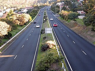
The South Arm Highway is a highway serving the southern suburbs of Hobart, on the eastern shore of the River Derwent in Tasmania, Australia. The highway is a major trunk road that carries heavy commuter traffic south from the Eastern Outlet to Howrah and Rokeby. As one of the Tasman Highway's principle Feeders and one of the eastern shore's major transport corridors, The South Arm Highway facilitates the movement of traffic between the suburbs and satellite communities to the south with the city centre and ultimately, other major cross city highways. With annual average daily traffic (AADT) of 17,000, the highway is considered a major traffic corridor within Hobart. The designation "South Arm Highway" arises from its journey south to South Arm.
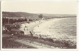
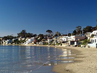
Bellerive Beach is a popular beach destination along the River Derwent in Bellerive, Hobart, Tasmania. The south facing beach neighbours the historic Kangaroo Battery coastal defences to the west and Howrah Beach to the east. The beach has views of the Derwent estuary, Howrah, Tranmere and Sandy Bay on the western shore. Bellerive Beach has an adjoining parkland with play equipment, barbecues and bathroom facilities and is backed by the Bellerive Oval, a narrow tree-lined reserve and private properties.


