Shailer Park, Queensland

Last updated

Shailer Park
City of Logan,  Queensland
Plantain Road Shailer Park Queensland.jpg
Plantain Road, 2014
Australia Queensland location map.svg
Red pog.svg
Shailer Park
Coordinates 27°39′02″S153°10′32″E / 27.6505°S 153.1755°E / -27.6505; 153.1755 (Shailer Park (centre of suburb))
Population12,182 (2021 census) [1]
 • Density1,504/km2 (3,895/sq mi)
Postcode(s) 4128
Area8.1 km2 (3.1 sq mi)
Time zone AEST (UTC+10:00)
Location
LGA(s) City of Logan
State electorate(s) Springwood
Federal division(s) Forde
Suburbs around Shailer Park:
Daisy Hill Mount Cotton Mount Cotton
Slacks Creek Shailer Park Cornubia
Tanah Merah Loganholme Cornubia

Shailer Park is a suburb in the City of Logan, Queensland, Australia. [2] In the 2021 census, Shailer Park had a population of 12,182 people. [1]

Contents

Geography

Shailer Park is a suburb of mainly middle class residential areas, and sits on hilly terrain between the Pacific Motorway and extensive forest and bushland to the north. The north-eastern part of the suburb is sometimes known as Kimberley Park, after a residential estate located in the area.[ citation needed ]

Shailer Park is a centre for employment, entertainment, and leisure in southeast Queensland. The Logan Hyperdome, a major regional shopping centre, is located in Shailer Park, and other commercial and community facilities have developed nearby. Largely because of this, the Queensland Government listed the suburb as a major activity centre in the South East Queensland Regional Plan 2005–2026. [3] The Loganholme bus station, a major bus interchange is located at the Logan Hyperdome.[ citation needed ]

History

The suburb is named after Francis Frederick Rising Shailer and his wife Catherine, [2] who arrived with their children in the area in 1866. Like many farmers in the area, they first grew cotton and later sugar. The Shailers were probably best known for their fruit growing and operated the first citrus orchard in southern Queensland, situated in Slacks Creek. The land selected by Francis Shailer was situated to the north of the current Shailer Road. Francis Shailer was a teacher at the first and second Slacks Creek Provisional Schools. He was also the first Clerk of the Tingalpa Divisional Board in 1880. The Shailers intermarried with other pioneering families in the district including the Dennis family, who were related to the Markwells, as well as the Murrays, who had an adjoining property along the Logan River. The property still exists at the end of Murrays Road. [4]

Francis’ son Alfred later farmed the area now known as Daisy Hill. At that time it was called Oakey Mountain and was owned by his grandfather, James Dennis. Alf's son Glen Shailer also farmed this property. Glen carried on the family's tradition of involvement in local government. He was elected to the Albert Shire Council in 1961 and served almost continuously until 1985. He was elected Mayor of Logan City in 1982 and served for one term. [4]

Shailer Park was originally named as a district on 1 September 1971, then as a sub-district of Slacks Creek on 1 September 1977. It was named and bounded as a locality on 31 March 1979 and revised to be a suburb on 31 August 1991. [2] [4]

The Kimberley Park estate was developed in 1973. [5]

Shailer Park State High School opened on 29 January 1980. [6]

Shailer Park State School opened on 25 January 1982. [6]

Kimberley Park State School opened 29 January 1985. [6] [7]

The Logan Hyperdome shopping centre opened in 1989 on the site on the site of the former Wild Waters Water Slide Park. [8]

The Logan Hyperdome Library opened in 1998 with a major refurbishment in 2014. [9]

Demographics

Historical population
YearPop.±%
2001 10,771    
2006 11,223+4.2%
2011 11,275+0.5%
2016 11,759+4.3%
2021 12,182+3.6%
Source: [10] [11] [12] [13] [1]

In the 2011 census, Shailer Park recorded a population of 11,275 people, 50.3% female and 49.7% male. The median age of the Shailer Park population was 36 years, 1 year below the national median of 37. 68.5% of people living in Shailer Park were born in Australia. The other top responses for country of birth were New Zealand 8.7%, England 6.8%, South Africa 1.7%, Scotland 0.9%, Philippines 0.7%. 88.7% of people spoke only English at home; the next most common languages were 0.6% Afrikaans, 0.6% Mandarin, 0.5% Samoan, 0.5% Greek, 0.5% Spanish. [12]

In the 2016 census, Shailer Park had a population of 11,759 people. [13]

In the 2021 census, Shailer Park had a population of 11,759 people.In the 2021 census, Shailer Park recorded a population of 12,182 people, 50.3% female and 49.7% male. The median age of the Shailer Park population was 39 years, 1 year over the national median of 38. 68.4% of people living in Shailer Park were born in Australia. The other top responses for country of birth were New Zealand 6.8%, England 5.1%, South Africa 1.6%, China 1.2% and India 1.0%. 82.8% of people spoke only English at home; the next most common languages were 1.6% Mandarin, 1.0% Korean, 0.8% Hindi, 0.7% Greek and 0.6% Afrikaans. [1]

Education

Kimberley Park State School, 2015 Kpsign.png
Kimberley Park State School, 2015

Shailer Park State School is a government primary (Prep-6) school for boys and girls at Bulwarna Street ( 27°39′37″S153°11′14″E / 27.6602°S 153.1871°E / -27.6602; 153.1871 (Shailer Park State School) ). [14] [15] In 2018, the school had an enrolment of 530 students with 37 teachers (33 full-time equivalent) and 22 non-teaching staff (14 full-time equivalent). [16] It includes a special education program. [14] [17]

Kimberley Park State School is a government primary (Prep-6) school for boys and girls at Floret Street ( 27°38′50″S153°10′38″E / 27.6473°S 153.1773°E / -27.6473; 153.1773 (Kimberley Park State School) ). [14] [18] In 2018, the school had an enrolment of 868 students with 67 teachers (59 full-time equivalent) and 28 non-teaching staff (19 full-time equivalent). [16] It includes a special education program. [14]

Shailer Park State High School is a government secondary (7-12) school for boys and girls at Leaf Street ( 27°39′43″S153°11′12″E / 27.6620°S 153.1867°E / -27.6620; 153.1867 (Shailer Park State High School) ). [14] [19] In 2018, the school had an enrolment of 913 students with 80 teachers (75 full-time equivalent) and 29 non-teaching staff (23 full-time equivalent). [16] It includes a special education program [14] [20]

Amenities

The Logan City Council operate the Logan Hyperdome Library at the Logan Hyperdome. [21]

Related Research Articles

<span class="mw-page-title-main">Upper Mount Gravatt, Queensland</span> Suburb of Brisbane, Queensland, Australia

Upper Mount Gravatt is a southern suburb in the City of Brisbane, Queensland, Australia. In the 2021 census, Upper Mount Gravatt had a population of 10,800 people.

<span class="mw-page-title-main">Woodridge, Queensland</span> Town in Queensland, Australia

Woodridge is a town and suburb in the City of Logan, Queensland, Australia. In the 2021 census, the suburb of Woodridge had a population of 12,982 people.

<span class="mw-page-title-main">Browns Plains, Queensland</span> Suburb of Logan City, Queensland, Australia

Browns Plains is a suburb in the City of Logan, Queensland, Australia. In the 2021 census, Browns Plains had a population of 6,632 people.

<span class="mw-page-title-main">Berrinba, Queensland</span> Suburb of Logan City, Queensland, Australia

Berrinba is a suburb in Logan City, Queensland, Australia. In the 2021 census, Berrinba had a population of 2,615 people.

<span class="mw-page-title-main">Carbrook, Queensland</span> Suburb of Logan City, Queensland, Australia

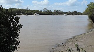
Carbrook is a suburb in the City of Logan, Queensland, Australia. Carbrook was previously called Gramzow, a name of German origin. The German name was anglicised in 1916 during World War I. In the 2021 census, Carbrook had a population of 1,330 people.

<span class="mw-page-title-main">Crestmead, Queensland</span> Suburb of Logan City, Queensland, Australia

Crestmead is a suburb in the City of Logan, Queensland, Australia. In the 2021 census, Crestmead had a population of 12,271 people.

<span class="mw-page-title-main">Daisy Hill, Queensland</span> Suburb of Logan City, Queensland, Australia

Daisy Hill is a suburb in the City of Logan, Queensland, Australia. In the 2021 census, Daisy Hill had a population of 6,925 people.

<span class="mw-page-title-main">Logan Central</span> Suburb of Logan City, Queensland, Australia

Logan Central is a mixed-use suburb and the central business district and administrative centre of the City of Logan, Queensland, Australia. In the 2021 census, Logan Central had a population of 6,210 people.

<span class="mw-page-title-main">Loganholme, Queensland</span> Suburb of Logan City, Queensland, Australia

Loganholme is a suburb in the City of Logan, Queensland, Australia. In the 2021 census, Loganholme had a population of 6,764 people.

<span class="mw-page-title-main">Loganlea, Queensland</span> Suburb of Logan City, Queensland, Australia

Loganlea is a suburb in the City of Logan, Queensland, Australia. In the 2021 census, Loganlea had a population of 8,716 people.

<span class="mw-page-title-main">Marsden, Queensland</span> Suburb of Logan City, Queensland, Australia

Marsden is a suburb in the City of Logan, Queensland, Australia. In the 2021 census, Marsden had a population of 14,795 people.

<span class="mw-page-title-main">Meadowbrook, Queensland</span> Suburb of Logan City, Queensland, Australia

Meadowbrook is a mixed-use suburb in the City of Logan, Queensland, Australia. The Logan Hospital and a TAFE college are located in the suburb. In the 2021 census, Meadowbrook had a population of 3,069 people.

<span class="mw-page-title-main">Springwood, Queensland</span> Suburb of Logan City, Queensland, Australia

Springwood is a suburb in the City of Logan, Queensland, Australia. In the 2021 census, Springwood had a population of 9,710 people.

<span class="mw-page-title-main">Tanah Merah, Queensland</span> Suburb of Logan City, Queensland, Australia

Tanah Merah is a residential suburb in the City of Logan, Queensland, Australia. It was officially named by the Queensland Place Names Board in 1971. In the 2021 census, Tanah Merah had a population of 4,754 people.

<span class="mw-page-title-main">Waterford West, Queensland</span> Suburb of Logan City, Queensland, Australia

Waterford West is a suburb in the City of Logan, Queensland, Australia. In the 2021 census, Waterford West had a population of 6,942 people.

<span class="mw-page-title-main">Holland Park West, Queensland</span> Suburb of Brisbane, Queensland, Australia

Holland Park West is a suburb in the City of Brisbane, Queensland, Australia. In the 2021 census, Holland Park West had a population of 6,468 people.

<span class="mw-page-title-main">Eagleby, Queensland</span> Suburb of Logan City, Queensland, Australia

Eagleby is a suburb in the City of Logan, Queensland, Australia. In the 2021 census, Eagleby had a population of 13,594 people.

<span class="mw-page-title-main">Slacks Creek, Queensland</span> Suburb of Logan City, Queensland, Australia

Slacks Creek is a suburb in the City of Logan, Queensland, Australia. In the 2021 census, Slacks Creek had a population of 10,408 people.

<span class="mw-page-title-main">Bahrs Scrub, Queensland</span> Suburb of Logan City, Queensland, Australia

Bahrs Scrub is an urban locality in the City of Logan, Queensland, Australia. In the 2021 census, Bahrs Scrub had a population of 4,508 people.

<span class="mw-page-title-main">Waterford, Queensland</span> Town in Queensland, Australia

Waterford is a town and suburb in the City of Logan, Queensland, Australia. In the 2021 census, the suburb of Waterford had a population of 5,796 people.

References

  1. 1 2 3 4 Australian Bureau of Statistics (28 June 2022). "Shailer Park (SSC)". 2021 Census QuickStats. Retrieved 9 November 2023. OOjs UI icon edit-ltr-progressive.svg
  2. 1 2 3 "Shailer Park – suburb in City of Logan (entry 45287)". Queensland Place Names. Queensland Government . Retrieved 8 July 2020.
  3. "South East Queensland Regional Plan 2005–2026". Archived from the original on 5 October 2008. Retrieved 23 October 2008.
  4. 1 2 3 "Shailer Park". Logan City Council . Archived from the original on 30 April 2009. Retrieved 24 October 2008.
  5. "Shailer Park". Local Studies Information Series. Logan City Council Libraries. 28 April 2010.
  6. 1 2 3 Queensland Family History Society (2010), Queensland schools past and present (Version 1.01 ed.), Queensland Family History Society, ISBN   978-1-921171-26-0
  7. "Opening and closing dates of Queensland Schools". Queensland Government . Retrieved 18 April 2019.
  8. "Loganholme". Logan City Council . Archived from the original on 19 July 2020. Retrieved 19 July 2020.
  9. "Public Libraries Statistical Bulletin 2016–17" (PDF). Public Libraries Connect. State Library of Queensland. November 2017. p. 14. Archived (PDF) from the original on 30 January 2018. Retrieved 30 January 2018.
  10. Australian Bureau of Statistics (9 March 2006). "Shailer Park (SSC)". 2001 Census QuickStats. OOjs UI icon edit-ltr-progressive.svg
  11. Australian Bureau of Statistics (25 October 2007). "Community Profile Series: Shailer Park (SSC)". 2006 Census of Population and Housing. Retrieved 9 November 2023.
  12. 1 2 Australian Bureau of Statistics (31 October 2012). "Shailer Park (SSC)". 2011 Census QuickStats. Retrieved 29 May 2022. OOjs UI icon edit-ltr-progressive.svg
  13. 1 2 Australian Bureau of Statistics (27 June 2017). "Shailer Park (SSC)". 2016 Census QuickStats. Retrieved 20 October 2018. OOjs UI icon edit-ltr-progressive.svg
  14. 1 2 3 4 5 6 "State and non-state school details". Queensland Government. 9 July 2018. Archived from the original on 21 November 2018. Retrieved 21 November 2018.
  15. "Shailer Park State School". Archived from the original on 5 October 2014. Retrieved 21 November 2018.
  16. 1 2 3 "ACARA School Profile 2018". Australian Curriculum, Assessment and Reporting Authority. Archived from the original on 27 August 2020. Retrieved 28 January 2020.
  17. "Shailer Park SS - Special Education Program". Archived from the original on 5 October 2014. Retrieved 21 November 2018.
  18. "Kimberley Park State School". Archived from the original on 17 March 2020. Retrieved 21 November 2018.
  19. "Shailer Park State High School". Archived from the original on 20 April 2013. Retrieved 21 November 2018.
  20. "Shailer Park SHS - Special Education Program". Archived from the original on 20 April 2013. Retrieved 21 November 2018.
  21. "Logan Hyperdome Library". Logan City Council . Archived from the original on 30 January 2018. Retrieved 30 January 2018.