Bethania Logan City, Queensland | |||||||||||||||
---|---|---|---|---|---|---|---|---|---|---|---|---|---|---|---|
Coordinates | 27°41′13″S153°09′27″E / 27.6869°S 153.1575°E | ||||||||||||||
Population | 5,385 (2016 census) [1] | ||||||||||||||
• Density | 928/km2 (2,405/sq mi) | ||||||||||||||
Postcode(s) | 4205 | ||||||||||||||
Elevation | 15 m (49 ft) | ||||||||||||||
Area | 5.8 km2 (2.2 sq mi) | ||||||||||||||
Time zone | AEST (UTC+10:00) | ||||||||||||||
Location |
| ||||||||||||||
LGA(s) | Logan City | ||||||||||||||
State electorate(s) | Waterford | ||||||||||||||
Federal division(s) | Forde | ||||||||||||||
|
Bethania ( /bɛθɑːniə/ ) is a suburb in the City of Logan, Queensland, Australia. [2] In the 2021 census, Bethania had a population of 6,333 people. [3]
Bethania lies south of the Logan River. The lower lying areas near the river occasionally suffer floods. [4]
Bethania is situated on the main Beenleigh railway line and the suburb is served by Bethania railway station ( 27°41′20″S153°09′33″E / 27.6889°S 153.1592°E ). [5]
Beaudesert railway line branches from the South Coast railway line just south of the Bethania railway station at ( 27°41′24″S153°09′36″E / 27.6901°S 153.1600°E ) and runs to Beaudesert. It has been out of commission since August 2004.
Bethania was founded by Germans during the 1860s and is home to many different nationalities. By 1866 a small township had developed. It is believed the name is derived from Bethany, the biblical village in Israel. [2] [6]
A Lutheran church was built in 1864 made from slabs on what is now the railway line. A cemetery was established beside the church with graves from 1866. In 1872 the present church was built close to the first church ( 27°41′29″S153°09′41″E / 27.691361°S 153.161392°E ). The road to the church became known as Church Road. [7]
The first railway bridge was destroyed by flood in 1887. A new concrete, steel and timber bridge lasted until 1972 when it was replaced by a pre-stressed concrete bridge. [6]
The suburb was affected badly by the 1974 Brisbane flood. Duck Island became part of the suburb when part of the river was silted up. [6] Sand and gravel has been mined from the alluvial deposits in recent years.
Bethania Lutheran Primary School opened on 27 January 1976. [8]
In the 2011 census, Bethania recorded a population of 4,590 people, 53.3% female and 46.7% male. [9] The median age of the Bethania population was 41 years, 4 years above the national median of 37. [9] 68.7% of the people living in Bethania were born in Australia. The other top responses for country of birth were England 6.6%, New Zealand 6%, Scotland 1.4%, Philippines 0.9% and Germany 0.9%. [9] 86.9% of the people spoke only English at home; the next most common languages were 0.8% Spanish, 0.5% German, 0.5% Hindi, 0.4% Tagalog, 0.3% Samoan. [9]
In the 2016 census, Bethania had a population of 5,385 people, 53.5% female and 46.5% male. The median age of the Bethania population was 47 years, 9 years above the national median of 38. 66.7% of the people living in Bethania were born in Australia. The other top responses for country of birth were England 6.8%, New Zealand 6.3%, Scotland 1.4%, Philippines 1.3%, and China (excludes SARs and Taiwan) 1.2%. 86.9% of the people spoke only English at home; the next most common languages were 1.0% Mandarin, 0.9% Cantonese, 0.8% Spanish, 0.4% German, and 0.4% Samoan. [1]
In the 2021 census, Bethania had a population of 6,333 people, 55.3% female and 44.7% male. The median age of the Bethania population was 48 years, 10 years above the national median of 38. 65.5% of the people living in Bethania were born in Australia. The other top responses for country of birth were New Zealand 7.6%, England 6.0%, Philippines 1.0%, China (excludes SARs and Taiwan) 1.0%, and Scotland 0.9%. 82.1% of the people spoke only English at home; the next most common languages were 1.1% Mandarin, 0.6% Samoan, 0.6% Spanish, 0.5% Cantonese, and 0.5% Hindi. [3]
Bethania has a number of heritage-listed sites, including:
Bethania Lutheran Primary School is a private primary (Prep-6) school for boys and girls at 66 Glastonbury Drive ( 27°41′39″S153°09′28″E / 27.6943°S 153.1578°E ). [10] [11] In 2018, the school had an enrolment of 287 students with 25 teachers (21 full-time equivalent) and 16 non-teaching staff (11 full-time equivalent). [12]
Palm Lake Christian Fellowship conduct their services at the Palm Lake Resort at 43 Goodooga Drive; it is part of the Wesleyan Methodist Church. [13]
Bethania railway station provides access to regular Queensland Rail City network services to Brisbane and Beenleigh.
Jimboomba is a town and locality in the City of Logan, Queensland, Australia. In the 2016 census, the locality of Jimboomba had a population of 13,201 people.
Beenleigh is a town and suburb in the City of Logan, Queensland, Australia. In the 2021 census, the suburb of Beenleigh had a population of 8,425 people.
Acacia Ridge is a southern suburb in the City of Brisbane, Queensland, Australia. In the 2021 census, Acacia Ridge had a population of 7,486 people.
Moorooka is a southern suburb in the City of Brisbane, Queensland, Australia. In the 2021 census, Moorooka had a population of 10,783 people.
Waterford West is a suburb in the City of Logan, Queensland, Australia. In the 2021 census, Waterford West had a population of 6,942 people.
Logan Village is a semi-rural town and locality in the City of Logan, Queensland, Australia. In the 2016 census, the locality of Logan Village had a population of 4,417 people. Logan Village was once known as the head of the navigable Logan River. Its importance as a town grew again when the railway arrived.
Munruben is a rural locality in the City of Logan, Queensland, Australia. Once a rural community, it has been developed into a low density residential community. In the 2021 census, Munruben had a population of 2,753 people.
The Beaudesert railway line is a disused branch railway in South East Queensland, Australia. The first section opened in 1885, the line was completed in 1888 and operated as a Queensland Government Railways (QGR) line until 1996. A heritage operation was undertaken for a short period in 2003. The Canungra railway line connected at Logan Village between 1915 and 1955, and the Beaudesert Shire Tramway connected with the terminal between 1903 and 1944. A study was undertaken in 2010 by the Queensland government concerning a potential Salisbury-to-Beaudesert rail corridor as a long-term potential proposal.
Edens Landing is a suburb in the City of Logan, Queensland, Australia. In the 2021 census, Edens Landing had a population of 5,094 people.
Bahrs Scrub is an urban locality in the City of Logan, Queensland, Australia. In the 2021 census, Bahrs Scrub had a population of 4,508 people.
Windaroo is a residential suburb in the outer southern areas of the City of Logan, Queensland, Australia. In the 2021 census, Windaroo had a population of 2,771 people.
Mount Warren Park is a residential suburb in the outer eastern area of the City of Logan, Queensland, Australia. The mountain of Mount Warren is within the suburb. In the 2016 census, Mount Warren Park had a population of 5,791 people.
Buccan is a rural locality in the City of Logan, Queensland, Australia. In the 2016 census Buccan had a population of 1,818 people.
Waterford is a town and suburb in the City of Logan, Queensland, Australia. In the 2021 census, the suburb of Waterford had a population of 5,796 people.
Biddaddaba is a rural locality in the Scenic Rim Region, Queensland, Australia. In the 2021 census, Biddaddaba had a population of 171 people.
Boyland is a rural locality in the Scenic Rim Region, Queensland, Australia. In the 2016 census Boyland had a population of 823 people.
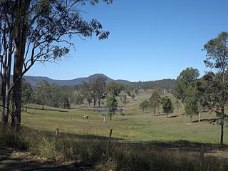
Kerry is a rural locality in the Scenic Rim Region, Queensland, Australia. In the 2016 census, Kerry had a population of 326 people.
Cedar Grove is a mixed-use locality in the City of Logan, Queensland, Australia. In the 2016 census, Cedar Grove had a population of 2,041 people.
Veresdale is a locality split between the City of Logan and the Scenic Rim Region, Queensland, Australia. In the 2016 census, Veresdale had a population of 392 people.
Gleneagle is a rural locality in the Scenic Rim Region, Queensland, Australia. In the 2016 census, Gleneagle had a population of 1,877 people.