Shilton, Oxfordshire

Last updated

Shilton
Shilton Church - geograph.org.uk - 350403.jpg
Holy Rood parish church, seen from the south
Oxfordshire UK location map.svg
Red pog.svg
Shilton
Location within Oxfordshire
Population626 (2011 Census)
OS grid reference SP2608
Civil parish
  • Shilton
District
Shire county
Region
Country England
Sovereign state United Kingdom
Post town Burford
Postcode district OX18
Dialling code 01993
Police Thames Valley
Fire Oxfordshire
Ambulance South Central
UK Parliament
Website Shilton Village Noticeboard
List of places
UK
England
Oxfordshire
51°46′29″N01°36′52″W / 51.77472°N 1.61444°W / 51.77472; -1.61444

Shilton is a village and civil parish about 1+12 miles (2.4 km) northwest of Carterton, Oxfordshire. The 2011 Census recorded the parish's population as 626. [1]

Contents

Geography

Shilton village is on Shill Brook: a stream that rises southwest of Burford, flows through Shilton and Alvescot to Black Bourton, where it becomes Black Bourton Brook, which joins the River Thames downstream from Radcot. Shilton was historically part of the manor of Great Faringdon, and most of Shilton parish was an exclave of Berkshire until the Counties (Detached Parts) Act 1844 transferred it to Oxfordshire.

Manor

When the Cistercian Beaulieu Abbey in Hampshire was founded in 1203–04, it was endowed with a group of manors that were headed by Great Faringdon and included Shilton. [2] Beaulieu retained the manors until 1538, when it surrendered all its properties to the Crown in the Dissolution of the Monasteries. [2] In about 1848 the architect and antiquarian Frederick S. Waller drew a plan and sections of an aisled barn at Shilton. [3] It had six bays and an internal timber frame built on two rows of five large timber posts, [4] This seems likely to have been a medieval barn, built when Beaulieu Abbey held Shilton Manor. [3] Beaulieu Abbey also held the manor at Great Coxwell, 9 miles (14 km) south of Shilton. Great Coxwell Barn, which was built for the Abbey around 1292, survives intact and is open to the public. It is somewhat larger and structurally more complex than the barn that Waller found at Shilton, but it gives an idea of the scale, style and quality of building that the Cistercians commissioned.

Tradition had it that a fire destroyed the barn at Shilton. [5] However, in 1971 an historian, PL Heyworth, reported that the stone walls of the barn and a few of its timbers still survived. Heyworth found a farm in the village had a stone-walled barn that had a modern arched corrugated steel roof, but had some stone corbels that would formerly have carried principal rafters of a former gabled roof. [3] Heyworth found that the lintels of two large doorways in the barn were re-used timbers that had been principal posts. [5] Each had the mortices that would have held a tie beam and a strut, both of which would have been parts of a timber roof. [5] The barn is near a house called the Old Manor, a medieval dovecote, a possible former medieval fishpond and a field called Conyger (i.e. it had been a place for rearing "coneys" – rabbits). [6] Heyworth therefore concluded that the barn is very likely to be the remains of a Cistercian barn. [7] The dovecote is cylindrical and has a conical roof. [8] It is early 16th century and is a Grade II* listed building. [8]

Plan, transverse section and incomplete longitudinal section of a barn at Shilton, drawn by FS Waller in about 1848 and discussed by PL Heyworth in 1971 ShiltonBarn drawings.tif
Plan, transverse section and incomplete longitudinal section of a barn at Shilton, drawn by FS Waller in about 1848 and discussed by PL Heyworth in 1971

Church and chapel

Holy Rood parish church Holy Rood, Shilton, Oxon - geograph.org.uk - 1630459.jpg
Holy Rood parish church

Church of England

The earliest parts of the Church of England parish church of the Holy Rood are the Norman nave, south aisle and arcade, all of which were built in about 1150. [9] The present Early English Gothic chancel was built in about 1250. [10] The bell tower was added in the 15th century. [10] The present side windows of the nave and aisle are also late Medieval Perpendicular Gothic additions. [10] The Gothic Revival architect C.C. Rolfe restored the building in 1884–88, adding the present rood screen. [10] The church is a Grade II* listed building. [11] Holy Rood church tower has three bells, all cast in 1854 by W. & J. Taylor [12] of Loughborough, who at the time also had a bell-foundry in Oxford. [13] Currently for technical reasons they are unringable. [12] Holy Rood also has a Sanctus bell that Henry III Bagley cast in 1730. [12] Bagley was from Chacombe, Northamptonshire but also had a foundry at Witney. [13] Holy Rood parish is now part of the Benefice of Shill Valley and Broadshire. [14]

Baptist

Shilton has a Baptist chapel that was built in the early or mid 19th century. [15] It may have been converted from a small barn. [15]

Economic history

Traditional houses and cottages in Shilton are built of local Cotswold stone. Shilton House was built in 1678 [10] and is a Grade II* listed building. [16] Elm Farm dates from 1683. [10] Shilton Bridge across Shill Brook is a small stone hump-back bridge that was probably built in the 18th century. [17] By the 1930s its stonework had become decayed, it was too narrow for modern traffic and its hump was too acute for some vehicles. [18] In 1938 Oxfordshire County Council rebuilt the bridge, making the road across it wider and reducing the hump. [18] The sides of the bridge were rebuilt using the original stones in their original relative positions as far as possible, while the widening of the bridge was achieved by inserting a concrete section in the middle of the road hidden from view. [18]

The ford and footbridge across Shill Brook Ford at Shilton - geograph.org.uk - 1556195.jpg
The ford and footbridge across Shill Brook

Amenities

Shilton has a 17th-century public house, the Rose and Crown. [19]

Notable residents

John Coghlan, drummer of the rock band Status Quo, lives in Shilton.[ citation needed ]

Related Research Articles

<span class="mw-page-title-main">Ickford</span> Human settlement in England

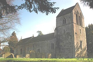
Ickford is a village and civil parish in the unitary authority area of Buckinghamshire, England. It is on the boundary with Oxfordshire, about 4 miles (6.4 km) west of the market town of Thame.

<span class="mw-page-title-main">Kelmscott</span> Human settlement in England

Kelmscott is a village and civil parish on the River Thames in West Oxfordshire, about 2 miles (3 km) east of Lechlade in neighbouring Gloucestershire. Since 2001 it has absorbed Little Faringdon, which had been a separate civil parish. The 2011 Census recorded the merged parish's population as 198.

<span class="mw-page-title-main">Culham</span> Human settlement in England

Culham is a village and civil parish in a bend of the River Thames, 1 mile (1.6 km) south of Abingdon in Oxfordshire. The parish includes Culham Science Centre and Europa School UK. The parish is bounded by the Thames to the north, west and south, and by present and former field boundaries to the east. It is low-lying and fairly flat, rising from the Thames floodplain in the south to a north-facing escarpment in the north up to 260 feet (80 m) above sea level. The 2011 Census recorded its population as 453.

<span class="mw-page-title-main">Tackley</span> Human settlement in England

Tackley is a village and civil parish beside the River Cherwell in Oxfordshire, England. It is about 6 miles (10 km) west of Bicester and 4+12 miles (7 km) north of Kidlington. The village consists of two neighbourhoods: Tackley itself, and Nethercott. The 2011 Census recorded the parish's population as 998.

<span class="mw-page-title-main">Black Bourton</span> Human settlement in England

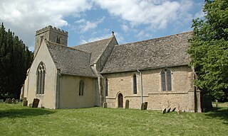
Black Bourton is a village and civil parish about 2 miles (3 km) south of Carterton, Oxfordshire. The village is on Black Bourton Brook, a tributary of the River Thames. The 2011 Census recorded the parish population as 266. RAF Brize Norton adjoins the parish. The northern boundary of the parish is along the middle of the main runway of the airfield.

<span class="mw-page-title-main">Broadwell, Oxfordshire</span> Human settlement in England

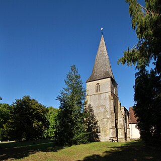
Broadwell is a village and civil parish about 2 miles (3 km) south-west of Carterton in West Oxfordshire. The 2011 Census recorded the parish's population as 218.

<span class="mw-page-title-main">Great Coxwell Barn</span> Medieval tithe barn in Great Coxwell, Oxfordshire, England

Great Coxwell Barn is a Medieval tithe barn at Great Coxwell, Oxfordshire, England. It is on the northern edge of the village of Great Coxwell, which is about 9 miles (14 km) northeast of Swindon in neighbouring Wiltshire.

<span class="mw-page-title-main">Launton</span> Human settlement in England

Launton is a village and civil parish on the eastern outskirts of Bicester, Oxfordshire, England. The 2011 Census recorded the parish's population as 1,204.

<span class="mw-page-title-main">Woodeaton</span> Human settlement in England

Woodeaton or Wood Eaton is a village and civil parish about 4 miles (6.4 km) northeast of Oxford, England. It also has a special needs school called Woodeaton Manor School.

<span class="mw-page-title-main">Northmoor, Oxfordshire</span> Human settlement in England

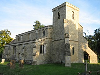
Northmoor is a village and civil parish in West Oxfordshire, about 6 miles (10 km) west of Oxford and almost the same distance southeast of Witney. Northmoor is in the valley of the River Thames, which bounds the parish to the east and south, and is close to the River Windrush which forms part of the parish's western boundary. The 2011 Census recorded the parish's population as 377.

<span class="mw-page-title-main">Broughton Poggs</span> Human settlement in England

Broughton Poggs is a village in the civil parish of Filkins and Broughton Poggs, in the West Oxfordshire district, in the county of Oxfordshire, England. Broughton Poggs is 3 miles (5 km) southwest of Carterton.

<span class="mw-page-title-main">Lewknor</span> Human settlement in England

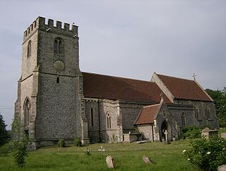
Lewknor is a village and civil parish about 5 miles (8 km) south of Thame in Oxfordshire. The civil parish includes the villages of Postcombe and South Weston. The 2011 Census recorded the parish's population as 663.

Frederick Sandham Waller was a British architect and antiquarian of Gloucester, where he was the resident architect to the Dean and Chapter of Gloucester Cathedral.

<span class="mw-page-title-main">Great Coxwell</span> Human settlement in England

Great Coxwell is a village and civil parish 2 miles (3 km) southwest of Faringdon in the Vale of White Horse, England. It was in Berkshire until the 1974 boundary changes transferred it to Oxfordshire. The 2021 Census recorded the parish's population as 295 in 124 households.

<span class="mw-page-title-main">Little Faringdon</span> Human settlement in England

Little Faringdon is a village and civil parish in West Oxfordshire, about 1 mile (1.6 km) north of Lechlade in neighbouring Gloucestershire. The 2001 Census recorded its population as 63.

<span class="mw-page-title-main">Shellingford</span> Human settlement in England

Shellingford, historically also spelt Shillingford, is a village and civil parish about 2+12 miles (4 km) south-east of Faringdon in the Vale of White Horse in Oxfordshire, England. It was part of Berkshire until the 1974 Local Government Act transferred it to Oxfordshire. The 2011 Census recorded the parish's population as 173.

<span class="mw-page-title-main">Holwell, Oxfordshire</span> Human settlement in England

Holwell is a village and civil parish about 2 miles (3 km) south of Burford in West Oxfordshire. The 2001 Census recorded the parish's population as 17.

<span class="mw-page-title-main">Westwell, Oxfordshire</span> Human settlement in England

Westwell is a small village and civil parish about 2 miles (3 km) southwest of the market town of Burford in Oxfordshire. It is the westernmost village in the county, close to the border with Gloucestershire.

<span class="mw-page-title-main">St Matthew's Church, Langford</span> Church in Oxfordshire , United Kingdom

The Parish Church of Saint Matthew, Langford is the Church of England parish church of Langford, a village in West Oxfordshire about 3 miles (5 km) northeast of Lechlade in neighbouring Gloucestershire.

<span class="mw-page-title-main">Sparsholt, Oxfordshire</span> Human settlement in England

Sparsholt is a village and civil parish about 3 miles (5 km) west of Wantage in the Vale of White Horse district of Oxfordshire. The parish includes the hamlet of Westcot about 12 mile (800 m) west of the village. Sparsholt was part of Berkshire until the 1974 boundary changes transferred the Vale of White Horse to Oxfordshire.

References

  1. "Area: Broadwell (Parish): Key Figures for 2011 Census: Key Statistics". Neighbourhood Statistics . Office for National Statistics . Retrieved 21 March 2015.
  2. 1 2 Ditchfield & Page 1907 , pp. 81–82
  3. 1 2 3 Heyworth 1971, p. 52.
  4. Heyworth 1971, Plate IX.
  5. 1 2 3 Heyworth 1971, p. 53.
  6. Heyworth 1971, pp. 53, 54.
  7. Heyworth 1971, p. 54.
  8. 1 2 Historic England. "Dovecote About 45 Metres North West of the Old Manor (1225800)". National Heritage List for England . Retrieved 23 August 2012.
  9. Sherwood & Pevsner 1974, p. 754.
  10. 1 2 3 4 5 6 Sherwood & Pevsner 1974 , pp. 755
  11. Historic England. "Church of the Holy Rood (1357113)". National Heritage List for England . Retrieved 23 August 2012.
  12. 1 2 3 Davies, Peter (24 November 2011). "Shilton Holy Rood". Dove's Guide for Church Bell Ringers . Central Council for Church Bell Ringers . Retrieved 23 August 2012.
  13. 1 2 Dovemaster (25 June 2010). "Bell Founders". Dove's Guide for Church Bell Ringers . Central Council for Church Bell Ringers . Retrieved 23 August 2012.
  14. Archbishops' Council (2010). "Benefice of Shill Valley and Broadshire". Church of England. Archived from the original on 26 December 2012. Retrieved 28 June 2013.
  15. 1 2 Historic England. "Baptist Chapel (1066563)". National Heritage List for England . Retrieved 23 August 2012.
  16. Historic England. "Manor House (1266168)". National Heritage List for England . Retrieved 23 August 2012.
  17. Historic England. "Bridge and Attached Retaining Wall (1225793)". National Heritage List for England . Retrieved 23 August 2012.
  18. 1 2 3 Leeming 1940 , p. 170
  19. The Rose & Crown

Sources