
Granville is a suburb in western Sydney, in the state of New South Wales, Australia. Granville is located 18 kilometres (11 mi) west of the Sydney central business district, split between the local government areas of Cumberland City Council and the City of Parramatta.
Rhodes is an Inner West suburb of Sydney, in the state of New South Wales, Australia. Rhodes is located 16 kilometres west of the Sydney central business district, in the local government area of the City of Canada Bay. It was formerly part of Concord Municipality until a merger with Drummoyne Council to form Canada Bay in December 2000.

The Municipality of Strathfield, also known as Strathfield Council, is a local government area located west of Sydney, in the state of New South Wales, Australia.

Epping is a suburb of Sydney, in the Australian state of New South Wales, 18 kilometres north-west of the Sydney central business district in the local government area of the City of Parramatta. Epping is located in the Northern Sydney region, and is sometimes simply referred to as the “North-West” or North Shore. The suburb is the most north-eastern area of the City of Parramatta. North Epping is a separate suburb to the north and under a different council, Hornsby Shire.

Auburn is a Western Sydney suburb in the state of New South Wales, Australia. Auburn is located 16 kilometres (9.9 mi) west of the Sydney central business district and is in the local government area of Cumberland City Council, having previously been the administrative centre of Auburn Council.

Rydalmere(formerly "Field of Mars") is a suburb of Sydney, in the state of New South Wales, Australia. Rydalmere is approximately 21 kilometres north-west of the Sydney central business district in the local government area of the City of Parramatta. Rydalmere is part of the Greater Western Sydney region.

Newington is a western suburb of Sydney, in the state of New South Wales, Australia. It is 16 kilometres west of the Sydney central business district, in the local government area of City of Parramatta.

Marsfield is a suburb in Northern Sydney, New South Wales, Australia. Marsfield is located 16 kilometres north-west of the Sydney central business district in the local government area of the City of Ryde. Marsfield is often referred to as part of the North Shore.

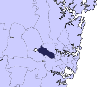
The City of Parramatta Council is a local government area located west of central Sydney in the Greater Western Sydney region. Parramatta Council is situated between the City of Ryde and Cumberland, where the Cumberland Plain meets the Hornsby Plateau, approximately 25 kilometres (16 mi) west of the Sydney central business district, in the state of New South Wales, Australia.

Telopea is a suburb of Greater Western Sydney, in the state of New South Wales, Australia. Telopea is located 23 kilometres north-west of the Sydney central business district, in the local government area of the City of Parramatta. The suburb is bordered by Kissing Point Road to the south and Pennant Hills Road to the north.

Rosehill is a suburb of Sydney, in the state of New South Wales, Australia. Rosehill is located 18 kilometres west of the Sydney central business district in the local government area of the City of Parramatta and is part of the Greater Western Sydney region.

North Strathfield is a suburb in the inner-west of Sydney, in the state of New South Wales, Australia. North Strathfield is located 15 kilometres west of the Sydney central business district, in the local government area of the City of Canada Bay. Strathfield and Strathfield South are separate suburbs, to the south.

North Parramatta is a suburb of the City of Parramatta, in the state of New South Wales, Australia 24 kilometres north-west of the Sydney central business district in the local government area of the City of Parramatta.
Lidcombe is a suburb in western Sydney, in the state of New South Wales, Australia. Lidcombe is located 15 km (9.32 mi) west of the Sydney central business district, in the local government areas of Cumberland Council and City of Parramatta.

Ermington(formerly "Field of Mars") is a suburb of Sydney, New South Wales, Australia. Ermington is located 19 kilometres north-west of the Sydney central business district, in the local government area of the City of Parramatta. Ermington lies on the northern bank of the Parramatta River.
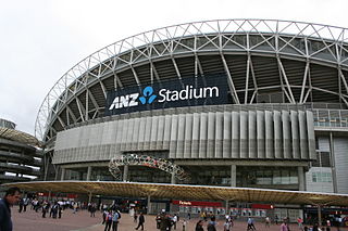
Sydney Olympic Park is a suburb of Greater Western Sydney, located 13 kilometres west of the Sydney central business district, in the local government area of the City of Parramatta Council. It is commonly known as Olympic Park but officially named Sydney Olympic Park. The area was originally part of the suburb of Homebush Bay, but was designated a suburb in its own right in 2009. The name Homebush is still used colloquially as a metonym for Stadium Australia as well as the Olympic Park precinct as a whole.
Bar Point is a suburb of the Central Coast region of New South Wales, Australia, located on the north bank of the Hawkesbury River 53 kilometres (33 mi) north of Sydney. It is part of the Central Coast Council local government area.

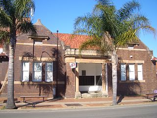
Newington House is a historic house in Silverwater, New South Wales, Australia and is located 20 kilometres (12 mi) west of the Sydney central business district, in the local government area of the City of Parramatta. The house and chapel are situated on the southern bank of the Parramatta River and are now enclosed by the Silverwater Correctional Centre. With Elizabeth Bay House and Camden Park, it is considered to be one of the three great houses of the County of Cumberland.

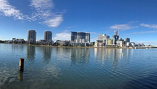
Wentworth Point is a suburb of Sydney, in the state of New South Wales, Australia. It is located 15 kilometres west of the Sydney central business district, in the local government area of City of Parramatta. It is on the western shore of Homebush Bay on the southern side of the Parramatta River. Wentworth Point is regarded as part of Greater Western Sydney region in some contexts, especially administrative contexts, while in other contexts, especially commercial contexts, it is referred to as part of the Inner West region.
The Cumberland City Council is a local government area located in the western suburbs of Sydney in the state of New South Wales, Australia. The Council was formed on 12 May 2016 from the merger of parts of the Cities of Auburn, Parramatta, and Holroyd.

