
The English River Thames is navigable from Cricklade or Lechlade to the sea, and this part of the river falls 71 meters (234 feet). There are 45 locks on the river, each with one or more adjacent weirs. These lock and weir combinations are used for controlling the flow of water down the river, most notably when there is a risk of flooding, and provide for navigation above the tideway.

The River Blackwater is a tributary of the River Loddon in England and, indirectly, of the River Thames. It rises at Rowhill Nature Reserve between Aldershot in Hampshire and Farnham in Surrey and runs northwards to join the Loddon near the village of Swallowfield in Berkshire. Along part of its length, the river forms the boundary between Hampshire and Surrey, and then between Hampshire and Berkshire. Rowhill Nature Reserve is an isolated remnant of the extensive heathland that once surrounded Farnborough and Aldershot. After 20 miles (32 km) the Blackwater is joined by the River Whitewater near Eversley. The river gives its name to the small town of Blackwater, Hampshire, upon the river near Camberley.

The River Loddon is a river in the English counties of Berkshire and Hampshire. It is a tributary of the River Thames, rising within the urban area of Basingstoke and flowing to meet the Thames near the village of Wargrave. The river has a total length of 28 miles (45 km) and, together with its tributaries, drains an area of 400 square miles (1,036 km2).

Marsh Lock is a lock and weir situated on the River Thames in England near Henley-on-Thames, Oxfordshire. The lock is close to the Berkshire bank, but accessed from the Oxfordshire side via two long walkways, the downstream one being near Mill Meadows. The first pound lock was built by the Thames Navigation Commission in 1773.

The River Pang is a small chalk stream river in the west of the English county of Berkshire, and a tributary of the River Thames. It runs for approximately 23 kilometres (14 mi) from its source near the village of Compton to its confluence with the Thames in the village of Pangbourne.

Shiplake Lock is a lock and weir situated on the River Thames in England between the villages of Shiplake and Lower Shiplake, Oxfordshire. It is just above the points where the River Loddon joins the Thames and Shiplake Railway Bridge crosses the river. The first pound lock was built by the Thames Navigation Commission in 1773.

The River Evenlode is a river in England which is a tributary of the Thames in Oxfordshire. It rises near Moreton-in-Marsh, Gloucestershire in the Cotswold Hills and flows south-east passing near Stow-on-the-Wold, Charlbury, Bladon, and Cassington, and its valley provides the route of the southern part of the Cotswold Line. The river flows for 45 miles (72 km) from source to the River Thames.

The Thames Path is a National Trail following the River Thames from its source near Kemble in Gloucestershire to the Thames Barrier at Charlton, south east London. It is about 184 miles (296 km) long. A path was first proposed in 1948 but it only opened in 1996.

The Thames Conservancy was a historical body responsible for the management of the River Thames in England. It was founded in 1857, initially replacing the jurisdiction of the City of London up to Staines and later taking responsibility for the whole river from Cricklade in Wiltshire to the sea at Yantlet Creek on the Isle of Grain. Responsibilities were reduced when the Tideway was transferred to the Port of London Authority in 1909 and in 1974 the Conservancy was taken into the Thames Water Authority.

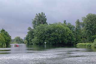
Phillimore Island is an elongated island in the River Thames in the county of Berkshire, England, near the villages of Shiplake, Oxfordshire and Wargrave, Berkshire. It is on the reach above Shiplake Lock.

Eye and Dunsden is a largely rural civil parish in the most southern part of English county of Oxfordshire.

Shiplake Railway Bridge carries the Henley Branch Line to Henley-on-Thames, England across the River Thames, connecting Shiplake in Oxfordshire with Wargrave in Berkshire. It crosses the river just downstream of Shiplake Lock on the reach above Marsh Lock.

Buck Ait is an island in the River Thames in Oxfordshire, England. It is on the reach above Shiplake Lock near Sonning.
The Lynch is an island in the River Thames in Berkshire, England. It is on the reach above Shiplake Lock near Lower Shiplake.
Hallsmead Ait is an island in the River Thames in Berkshire, England. It is on the reach above Shiplake Lock near Lower Shiplake.

Handbuck Eyot or Handbuck Ait is a thin, wooded island in the River Thames in England towards the eastern edge of the villages of Shiplake, Oxfordshire. It is on the reach above Marsh Lock.

Ferry Eyot or Ferry Ait is an island in the River Thames in England near the villages of Shiplake, Oxfordshire and Wargrave, Berkshire. It is on the reach above Marsh Lock.
Poplar Eyot or Poplar Ait is an island in the River Thames in England near the villages of Shiplake, Oxfordshire and Wargrave, Berkshire. It is on the reach above Marsh Lock.
The Unnamed Eyot is an island in the River Thames in Berkshire, England, north of the village of Wargrave, Berkshire, its parish in civil terms and ecclesiastical parish in the Church of England. It is on the reach above Marsh Lock.

The Berry Brook is a stream close to Sonning Eye in the flood plain of the River Thames, in southern Oxfordshire, England.
