
The Jubilee River is a hydraulic channel in southern England. It is 11.6 km (7.2 mi) long and is on average 45 metres wide. It was constructed in the late 1990s and early 2000s to take overflow from the River Thames and so alleviate flooding to areas in and around the towns of Maidenhead, Windsor, and Eton in the counties of Berkshire and Buckinghamshire. It achieves this by taking water from the left bank of the Thames upstream of Boulter's Lock near Maidenhead and returning it via the north bank downstream of Eton. Although successful in its stated aims, residents of villages downstream, such as Wraysbury, claim it has increased flooding in those locations.

Marsh Lock is a lock and weir situated on the River Thames in England, about 1 mile upstream of Henley Bridge in Henley-on-Thames, Oxfordshire. The lock is close to the Berkshire bank, but accessed from the Oxfordshire side via two long walkways, the downstream one being near Mill Meadows. The first pound lock was built by the Thames Navigation Commission in 1773.
Sonning Lock is a lock and associated weir situated on the River Thames at the village of Sonning near Reading, Berkshire, England. The first lock was built by the Thames Navigation Commission in 1773 and it has been rebuilt three times since then. There is a weir a little upstream at the top of the island where Sonning Backwater separates from the main course of the river.

The Windsor Bridge or Windsor Town Bridge, an iron and granite arch bridge over the River Thames, is located between the towns of Windsor and Eton in the English county of Berkshire. The Thames Path crosses the river here. The bridge carries pedestrian and cycle traffic, and crosses the Thames just above Romney Lock. It is a Grade II listed structure.
This article lists the islands in the River Thames, or at the mouth of a tributary, in England. It excludes human-made islands built as part of the building of forty-five two-gate locks which each accompany a weir, and islets subordinate to and forming part of the overall shape of another. The suffix -ey is common across England and Scotland and cognate with ait and meaning island, a term – as ait or eyot – unusually well-preserved on the Thames. A small minority of list entries are referred to as Island, Ait or Eyot and are vestiges, separated by a depression in the land or high-water-level gully.

Shiplake Lock is a lock and weir situated on the River Thames in England between the villages of Shiplake and Lower Shiplake, Oxfordshire. It is just above the points where the River Loddon joins the Thames and Shiplake Railway Bridge crosses the river. The first pound lock was built by the Thames Navigation Commission in 1773.

Sonning Eye is a hamlet on the River Thames in the Sonning Common ward of South Oxfordshire, England, in the civil parish of Eye & Dunsden, at what is since 1974 the southernmost tip of Oxfordshire.

Cookham Lock is a lock with weirs situated on the River Thames near Cookham, Berkshire, about a half-mile downstream of Cookham Bridge. The lock is set in a lock cut which is one of four streams here and it is surrounded by woods. On one side is Sashes Island and on the other is Mill Island connected to Formosa Island, the largest on the non-tidal Thames.
Windsor Racecourse, also known as Royal Windsor Racecourse, is a thoroughbred horse racing venue located in Windsor, Berkshire, England. It is one of only two figure-of-eight courses in the United Kingdom, the other being at Fontwell Park.

Sunbury Lock is a lock complex of the River Thames in England near Walton-on-Thames in north-west Surrey, the third lowest of forty four on the non-tidal reaches. The complex adjoins the right, southern bank about 1⁄2 mile (0.80 km) downstream of the Weir Hotel.

Old Windsor Lock is a lock on the River Thames in England on the right bank beside Old Windsor, Berkshire. The lock marks the downstream end of the New Cut, a meander cutoff built in 1822 by the Thames Navigation Commissioners which created Ham Island. The lock and a wider footbridge give access to the island. Two weirs are associated; the smaller adjoins and the larger is upstream. The lock is the ninth lowest of the forty-five on the river.

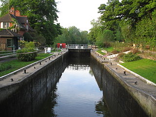
Romney Lock is a lock on the River Thames in England near Windsor and Eton, about half a mile downstream of Windsor Bridge. It is on the Windsor side of the river next to a boatyard and adjoins Romney Island, a long strip-shaped ait in the middle of the river. The first lock was built by the Thames Navigation Commission in 1798.
Boveney Lock is a lock on the River Thames situated on the Buckinghamshire bank opposite the Windsor Racecourse and close to Eton Wick. Boveney is a village a little way upstream on the same side. The lock was first built in 1838 by the Thames Navigation Commission. The lock was rebuilt in 1898 closer to the Buckinghamshire bank, and a set of boat rollers were installed on the old site.

Bush Ait is an island of Clewer, Berkshire in the Thames on the reach above Boveney Lock at the mouth of the Clewer Mill Stream which leads to Windsor Racecourse Marina. The island is unpopulated and wooded.

Guards Club Island, also known as Bucks Ait or bucks' eyot is an island in the River Thames connected by footbridge by to Maidenhead, Berkshire accommodating a pier adjoining the Sounding Arch part of the railway bridge which was built in 1838 to designs by Brunel. The thin small island is connected to Guards Club Park by a low cast-iron and wood footbridge which blocks the near channel (backwater) to boat navigation apart from kayaks. The island gets its alternative name from eel bucks from which the footbridge was adapted in 1865 to allow access to its Guards Club Boathouse.
The Abbey River is a right-bank backwater of the River Thames in England, in Chertsey, Surrey — in the town's northern green and blue buffers. The L-shaped conduit adjoins mixed-use flood plain: water-meadows landscaped for a golf course, a motorway and a fresh water treatment works on the island it creates, Laleham Burway to its east and north in turn. Its offtake from the Thames is at the apex of Penton Hook, Staines upon Thames below its lower weir close to the Chertsey-Thorpe boundary in the Borough of Runnymede. Its outfall is the weir pool of Chertsey Lock back into the Thames, visible from Chertsey Bridge. The Environment Agency plans to build similar channels to the upstream Jubilee River, one of which will intersect the watercourse, another of which will be close to its outfall, thereby compensating for loss of its historic bypass functions.

St Patrick's Stream or Patrick Stream is a backwater of the River Thames in England, which flows into the River Loddon near Wargrave, Berkshire. It leaves the Thames on the reach above Shiplake Lock near Buck Ait, downstream of Sonning.
The Colne Brook is a river in England that is a distributary of the River Colne which runs from Uxbridge Moor, there forming the western border of Greater London, to the River Thames just below Bell Weir Lock in Hythe End, Wraysbury, Berkshire.

Datchet Bridge, also known as The Divided Bridge, was a road bridge which crossed the River Thames at Datchet from 1706 until it was demolished in 1848. It was situated on the reach between Old Windsor Lock and Romney Lock and linked Windsor on the Berkshire bank to Datchet on the Buckinghamshire side. The bridge replaced a ferry service which had operated at the site since at least the middle of the 13th century.
Hennerton Backwater is a narrow backwater of the River Thames on the reach above Marsh Lock near the villages of Shiplake, Oxfordshire and Wargrave, Berkshire.


