
The Lincolnshire Wildlife Trust,, covers the whole ceremonial county of Lincolnshire, England. It was founded in 1948 as a voluntary charitable organisation dedicated to conserving the wildlife and wild places of Lincolnshire and to promoting the understanding and enjoyment of the natural world.

The Cotswold Water Park is the United Kingdom's largest marl lake system, straddling the Wiltshire–Gloucestershire border, northwest of Cricklade and south of Cirencester. There are 180 lakes, spread over 42 square miles (110 km2).

The Wildlife Trust for Bedfordshire, Cambridgeshire and Northamptonshire (WTBCN) is a registered charity which manages 126 nature reserves covering 3,945 hectares. It has over 35,000 members, and 95% of people in Bedfordshire, Cambridgeshire and Northamptonshire live within five miles of a reserve. In the year to 31 March 2016 it employed 105 people and had an income of £5.1 million. It aims to conserve wildlife, inspire people to take action for wildlife, offer advice and share knowledge. The WTBCN is one of 36 wildlife trusts covering England, and 46 covering the whole of the United Kingdom.

Castle Bytham is a village and civil parish of around 300 houses in South Kesteven, Lincolnshire, England. It is located 9 miles (15 km) north of Stamford and 9 miles (15 km) west of Bourne.The population was measured at 768 in 317 households at the 2011 census.
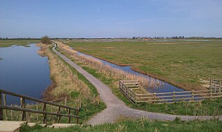
Frampton Marsh is a nature reserve in Lincolnshire, England. The reserve is situated on the coast of The Wash, some 4 miles from the town of Boston, between the outfalls of the Rivers Welland and Witham, and near the village of Frampton. The majority of the reserve is managed by the RSPB with a small part of the saltmarsh managed by the Lincolnshire Wildlife Trust. There is a small visitor centre at the entrance to the reserve.
Little Bytham is a village and civil parish in the South Kesteven district of Lincolnshire, England. The population of the civil parish at the 2011 census was 384. It lies on the B1176 road, 4 miles (6 km) south from Corby Glen and 6 miles (10 km) north from Stamford.

Kirkby on Bain is a village and civil parish in the East Lindsey district of Lincolnshire, England. It lies on the River Bain between Horncastle and Coningsby, and just west of the A153 road. Close to the north is the village of Haltham.

Sevenoaks Gravel Pits is a 73.7-hectare (182-acre) biological Site of Special Scientific Interest on the northern outskirts of Sevenoaks in Kent. It is managed by Kent Wildlife Trust as the Sevenoaks Wildlife Reserve and Jeffery Harrison Visitor Centre.
Whisby Moor is a small moor situated close to the A46 road, west of North Hykeham, in the North Kesteven district of Lincolnshire, England.
Witham on the Hill is a village and civil parish in the South Kesteven district of Lincolnshire, England. The population of the civil parish was 260 at the 2011 census.
Careby Aunby and Holywell is a civil parish in the district of South Kesteven, south-west Lincolnshire, in England. It stretches from the county border with Rutland in the west to the River West Glen in the east. The B1176 road from Corby Glen passes through Careby and on past Aunby toward Stamford. The main London to Scotland railway line passes through the parish, the line upon which Mallard took the speed record for the LNER.

Herts and Middlesex Wildlife Trust manages over 40 nature reserves covering nearly 810 hectares north of London, in Hertfordshire and the historic county of Middlesex, part of which is divided between the London boroughs of Barnet, Enfield, Harrow and Hillingdon. It has over 21,000 members, and is one of 46 Wildlife Trusts across the UK. It is a Registered Charity, with its Registered Office in St Albans, and had an income in the year to 31 March 2014 of over £1.5 million.
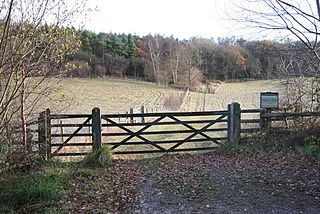
Lincolnshire Gate is the name given to a corner in the road between Holywell, Lincolnshire and Pickworth, Rutland to the south-west of Castle Bytham, in Lincolnshire, England. It is situated approximately 5 miles (8 km) north from Stamford. It describes a point where this small country road crosses the county border between Lincolnshire and Rutland, to pass between Newell Wood and Howitts Gorse. On either side are the remains of small quarries, worked from the Middle Ages till the early 20th century for building and road stone for nearby use.

The Idle Valley Nature Reserve, also known as Lound Gravel Pits or Sutton and Lound Gravel Pits, is a wetland Site of Special Scientific Interest (SSSI) situated north-west of the town of Retford in the Bassetlaw district of north Nottinghamshire. The nature reserve is situated along the western bank of the River Idle and east of the villages of Sutton cum Lound and Lound. The nature reserve is managed by the Nottinghamshire Wildlife Trust.
