
New England or New England North West is the name given to a generally undefined region in the north of the state of New South Wales, Australia, about 60 kilometres (37 miles) inland, that includes the Northern Tablelands and the North West Slopes regions. The population of the region is 202,160 (2006), with over a quarter of the population being from Tamworth Regional Council.

Tenterfield is a regional town in New South Wales, Australia. At the 2016 census, Tenterfield had a population of 4,066. Tenterfield's proximity to many regional centres and its position on the route between Sydney and Brisbane led to its development as a centre for the promotion of the federation of the Australian colonies.

Glen Innes is a parish and town on the Northern Tablelands, in the New England region of New South Wales, Australia. It is the centre of the Glen Innes Severn Shire Council. The town is located at the intersection of the New England Highway and the Gwydir Highway. At the 2016 census, Glen Innes had a population of 6,155.

Belmont is a suburb in the Hunter Region of New South Wales, Australia, located 20 kilometres (12 mi) from Newcastle's central business district on the eastern side of Lake Macquarie and is part of the City of Lake Macquarie.

Darlington Point is a small town on the banks of the Murrumbidgee River in the Riverina district of western New South Wales, Australia. It is part of the Murrumbidgee Council local government area. The centre of town is four kilometres from the Sturt Highway, along Kidman Way. Darlington Point is 631 kilometres (392 mi) south west of Sydney and 33 kilometres (21 mi) south of Griffith. At the 2011 census, Darlington Point had a population of 1,016.

Ben Lomond is a village on the Northern Tablelands in the New England region of New South Wales, Australia. The village is situated 6 km off the New England Highway between Armidale and Glen Innes. It was located in the Guyra Shire local government area until that council was amalgamated into the Armidale Regional Council on 12 May 2016, with parts of the surrounding district in Glen Innes Severn Shire and Inverell Shire. It is primarily a farming area, with most of the residents involved in sheep, cattle and grain farming.
The Ngarabal are an Aboriginal people of the area from Ashford, Tenterfield and Glen Innes in northern New South Wales, Australia.

Woodford is a village in the Blue Mountains in New South Wales, Australia, about 90 kilometres west of Sydney. Its elevation is 609 metres (1,998 ft) above sea level. It is situated on the Great Western Highway and has a railway station on the Main Western railway line served by NSW TrainLink's Blue Mountains services. At the 2016 census, Woodford had a population of 1,934.

Emmaville is a town on the Northern Tablelands in the New England region of New South Wales, Australia. It is in the Glen Innes Severn Council district.

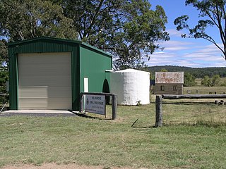
Bolivia is a locality on the Northern Tablelands in the New England region of New South Wales, Australia. The remains of the settlement comprises the former Bolivia Hotel, a disused post office, a disused railway siding and a community hall.
Wellingrove is a village located on the Wellingrove Road about 20 kilometres north west of Glen Innes, New South Wales on the Northern Tablelands, New South Wales, Australia. At the 2006 census, Wellingrove had a population of 113.

Glencoe is a village on the Northern Tablelands, New South Wales, Australia. It is part of the Glen Innes Severn Shire Council local government area. It has an elevation of about 1,150 metres (3,770 ft). At the 2016 census, Glencoe had a population of 192 people.

Llangothlin is a rural locality with several houses, 11 kilometres (7 mi) north of Guyra on the Northern Tablelands in the New England region of New South Wales, Australia. Llangothlin was located in the Guyra Shire local government area until that council was amalgamated into the Armidale Regional Council on 12 May 2016.

Deepwater is a parish and small town 40 kilometres north of Glen Innes on the Northern Tablelands, New South Wales, Australia. At the 2006 census, Deepwater had a population of 307, with 489 people in the area.

Kentucky is a village in the New England region of New South Wales, Australia. The village is situated about 17 kilometres (11 mi) to the south of Uralla and 35 kilometres (22 mi) to the north west of Walcha and approximately 7 kilometres (4 mi) off the New England Highway. Kentucky is located 540 kilometres (336 mi) by rail from Sydney in Sandon County on the Northern Tablelands. The village is at an altitude of about 1066 m and is within Uralla Shire. At the 2006 census, Kentucky and the surrounding area had a population of 311.
Dundee is a rural locality about 40 kilometres north of Glen Innes on the Northern Tablelands, New South Wales, Australia. It is situated on the New England Highway at the Severn River in Severn parish, Gough County, New South Wales. The elevation is 985 metres.

Wollombi is a small village in the Hunter Region of New South Wales, Australia. It is within the Cessnock City Council LGA, situated 29 kilometres (18 mi) southwest of Cessnock and 128 km (80 mi) north of Sydney. To the south is the village of Laguna, to the east, the village of Millfield and to the north, the village of Broke.

Ballandean is a small town and locality in the Granite Belt Region of the Southern Downs, Queensland, Australia. It is on the Queensland border with New South Wales. At the 2016 census the town recorded a population of 338. The town has a number of nearby vineyards which attracted tourists to the area.
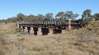
The Tenterfield Creek railway bridge is a heritage-listed former railway bridge that carried the Main North line across the Tenterfield Creek from Sunnyside to Jennings, both in the Tenterfield Shire local government area of New South Wales, Australia. It was designed by John Whitton and Engineer-in-Chief for NSW Government Railways and built in 1888. The bridge is also known as the Sunnyside rail bridge over Tenterfield Creek. The property is owned by RailCorp, an agency of the Government of New South Wales and was added to the New South Wales State Heritage Register on 2 April 1999.

Glen Innes Showground is a heritage-listed showground at Bourke Street, Glen Innes, Glen Innes Severn, New South Wales, Australia. It was designed by various architects, including Thompson and Holmes, J. P. O'Connor, Rowland Bros and Madigan and Cusick. It was built from 1873 by various builders, including A. W. Lane, G. Cooper and H. A. Tutt and Son. It was added to the New South Wales State Heritage Register on 4 September 2015.
