Wool is the textile fiber obtained from sheep and other animals, including cashmere and mohair from goats, qiviut from muskoxen, hide and fur clothing from bison, angora from rabbits, and other types of wool from camelids.

New England or New England North West is the name given to a generally undefined region in the north of the state of New South Wales, Australia, about 60 kilometres (37 miles) inland, that includes the Northern Tablelands and the North West Slopes regions. The population of the region is 202,160 (2006), with over a quarter of the population being from Tamworth Regional Council.

The Merino is one of the most historically relevant and economically influential breeds of sheep, much prized for its wool. The origins of the breed are the subject of debate, with alternatives of it originating in flocks transferred from Morocco as early as the 12th century, originating and being improved in Extremadura in southwestern Spain, in the 12th and 13th centuries or from the selective crossbreeding of Spanish ewes with imported rams at several different periods. It was instrumental in the economic development of 15th and 16th century Spain, which initially held a monopoly on the trade in its wool. Since the end of the 18th century, the breed was further refined in New Zealand and Australia, giving rise to the modern Merino.

Uralla is a town on the Northern Tablelands, New South Wales, Australia. The town is located at the intersection of the New England Highway and Thunderbolts Way, 465 kilometres (289 mi) north of Sydney and about 23 kilometres (14 mi) south west of the city of Armidale. At the 2016 census, the township of Uralla had a population of 2,388 people,.

Walcha is a town at the south-eastern edge of the Northern Tablelands, New South Wales, Australia.

Thunderbolts Way is a 290-kilometre (180 mi) country road located in the Northern Tablelands region of New South Wales, Australia. The road links Gloucester to Walcha, Uralla, where it very briefly joins the New England Highway and, to Copes Creek, 16 km (10 mi) south of the Gwydir Highway intersection at Inverell. The road is fully sealed and passes through thickly forested mountain areas with many nearby national parks and nature reserves.

The Northern Tablelands, also known as the New England Tableland, is a plateau and a region of the Great Dividing Range in northern New South Wales, Australia. It includes the New England Range, the narrow highlands area of the New England region, stretching from the Moonbi Range in the south to the Queensland border in the north. The region corresponds generally to the Bureau of Meteorology forecast area for the Northern Tablelands which in this case includes Inverell although it is significantly lower in elevation.

The Armidale Dumaresq Council is a former local government area in the New England and Northern Tablelands regions of New South Wales, Australia. This area was formed in 2000 from the merger of the original City of Armidale with the surrounding Dumaresq Shire and abolished on 12 May 2016, where the council, together with Guyra Shire, was subsumed into the Armidale Regional Council with immediate effect.

Walcha Shire is a local government area located in the New England region of New South Wales, Australia. The Shire is situated adjacent to the junction of the Oxley Highway and Thunderbolts Way and is 20 kilometres (12 mi) east of the Main North railway line passing through Walcha Road. The shire was formed on 1 June 1955 through the amalgamation of Apsley Shire and the Municipality of Walcha.

Uralla Shire is a local government area located in the New England region of New South Wales, Australia. The New England Highway passes through the Shire.

Walcha Road is a rural village with a population of about 20, located 19 kilometres (12 mi) west of Walcha in the Northern Tablelands of New South Wales, Australia.

Brackendale is a rural locality situated on the Riamukka Road about 29 kilometres south of Walcha, New South Wales within the Walcha Shire local government area on the Northern Tablelands in Australia.

Woolbrook is a village in the New England region of New South Wales, Australia. The nearest town, Walcha is 29 km to the east of Woolbrook. At the 2011 census, Woolbrook had a population of 248.
Tia, is a settlement and parish located approximately 30 kilometres east of Walcha, on the Northern Tablelands region of New South Wales, Australia.

Niangala is a village located on the south-eastern edge of the Northern Tablelands area of New South Wales, Australia. It is on the Moonbi Range which is part of the Great Dividing Range, at approximately 1,300 metres (4,265 ft) above sea level. The village is in Walcha parish in Parry County. At the 2011 census, Niangala and the surrounding area had a population of 142.

Kentucky is a village in the New England region of New South Wales, Australia. It is about 17 kilometres (11 mi) south of Uralla and 35 kilometres (22 mi) north-west of Walcha and about 7 kilometres (4 mi) off the New England Highway. Kentucky is located 540 kilometres (336 mi) by rail from Sydney in Sandon County on the Northern Tablelands. It is at an altitude of 1066m and is within Uralla Shire. At the 2016 census, Kentucky had a population of 158.

Black Mountain is a village situated between Armidale and Guyra, located on the Northern Tablelands in the New England region of New South Wales, Australia. Situated within Armidale Regional Council, as at the 2016 census, Black Mountain had a population of 310.

Kingstown is a rural village, 40 kilometres (25 mi) north west of Uralla on the Northern Tablelands in the New England region of New South Wales, Australia. At the 2006 census, Kingstown had a population of 137 people. It has a public school, church, general store, Landcare Group and New South Wales Rural Fire Service. The main industries are sheep and beef cattle breeding with some timber production.
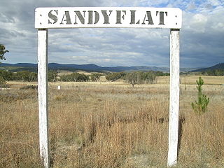
Sandy Flat is a historic locality on the Northern Tablelands in the New England region of New South Wales, Australia. This locality is situated on New England Highway and the former Main North Railway line about 20 kilometres south of Tenterfield. At the 2011 census, Sandy Flat had a population of 209 people.

Ardglen is a village on the Main North railway line and close to the New England Highway on the North West Slopes region of New South Wales, Australia.