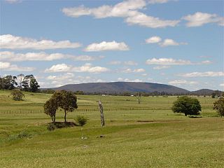
Ebor is a village on Waterfall Way on the Northern Tablelands in New South Wales, Australia. It is situated about 80 km (50 mi) east of Armidale and about a third of the way between Armidale and the coast. Dorrigo to the east is 46 kilometres (29 mi) away with the Coffs Coast 55 kilometres (34 mi) away along Waterfall Way. In the 2016 census, Ebor's zone had a population of 166.

New England is a vaguely defined region in the north of the state of New South Wales, Australia, about 60 km inland from the Tasman Sea. The area includes the Northern Tablelands and the North West Slopes regions. As of 2006, New England had a population of 202,160, with over a quarter of the people living in the area of Tamworth Regional Council.

Uralla is a town on the Northern Tablelands, New South Wales, Australia. The town is located at the intersection of the New England Highway and Thunderbolts Way, 465 kilometres (289 mi) north of Sydney and about 23 kilometres (14 mi) south west of the city of Armidale. At the 2016 census, the township of Uralla had a population of 2,388 people,.

Walcha is a town at the south-eastern edge of the Northern Tablelands, New South Wales, Australia.

Dongara is a town 351 kilometres (218 mi) north-northwest of Perth, Western Australia on the Brand Highway. The town is located at the mouth of the Irwin River. The area is marketed as the 'Rock lobster capital of Australia'.

Tingha is a small town on the Northern Tablelands, New South Wales, Australia in Inverell Shire. Formerly part of Armidale Region, on 1 July 2019, responsibility for Tingha was transferred from Armidale Regional Council to Inverell Shire Council. The town is 30 kilometres (19 mi) south of Inverell and 629 kilometres (391 mi) north-north-east of Sydney. Tingha is an Aboriginal word for "flat or level".

Guyra is a town situated midway between Armidale and Glen Innes on the Northern Tablelands in the New England region of New South Wales, Australia. It is within Armidale Regional Council and at the 2016 census, it had a population of 1,983.

Kilcoy is a rural town and locality in the Somerset Region, Queensland, Australia. In the 2016 census, the locality of Kilcoy had a population of 1,898 people.

The Northern Tablelands, also known as the New England Tableland, is a plateau and a region of the Great Dividing Range in northern New South Wales, Australia. It includes the New England Range, the narrow highlands area of the New England region, stretching from the Moonbi Range in the south to the Queensland border in the north. The region corresponds generally to the Bureau of Meteorology forecast area for the Northern Tablelands which in this case includes Inverell although it is significantly lower in elevation.

Ben Lomond is a village on the Northern Tablelands in the New England region of New South Wales, Australia. The village is situated 6 km off the New England Highway between Armidale and Glen Innes. It was located in the Guyra Shire local government area until that council was amalgamated into the Armidale Regional Council on 12 May 2016, with parts of the surrounding district in Glen Innes Severn Shire and Inverell Shire. It is primarily a farming area, with most of the residents involved in sheep, cattle and grain farming.

The Armidale Dumaresq Council is a former local government area in the New England and Northern Tablelands regions of New South Wales, Australia. This area was formed in 2000 from the merger of the original City of Armidale with the surrounding Dumaresq Shire and abolished on 12 May 2016, where the council, together with Guyra Shire, was subsumed into the Armidale Regional Council with immediate effect.

Walcha Shire is a local government area located in the New England region of New South Wales, Australia. The Shire is situated adjacent to the junction of the Oxley Highway and Thunderbolts Way and is 20 kilometres (12 mi) east of the Main North railway line passing through Walcha Road. The shire was formed on 1 June 1955 through the amalgamation of Apsley Shire and the Municipality of Walcha.

Guyra Shire is the name of a former local government area located in the New England region of New South Wales, Australia. The shire was abolished on 12 May 2016, where the council, together with the Armidale Dumaresq Shire, was subsumed into the Armidale Regional Council with immediate effect.

Carmila is a rural town and coastal locality in the Isaac Region, Queensland, Australia. In the 2016 census, the locality of Carmila had a population of 333 people.

Wallabadah is a town in the New England region of New South Wales, Australia. The town is located 55 kilometres south of Tamworth on the New England Highway and is in the Liverpool Plains Shire. At the 2006 census, Wallabadah had a population of 746.

Yarrowyck is a rural locality on the western slopes of the Northern Tablelands, New South Wales, Australia.

Llangothlin is a rural locality with several houses, 11 kilometres (7 mi) north of Guyra on the Northern Tablelands in the New England region of New South Wales, Australia. Llangothlin was located in the Guyra Shire local government area until that council was amalgamated into the Armidale Regional Council on 12 May 2016.

Black Mountain is a village situated between Armidale and Guyra, located on the Northern Tablelands in the New England region of New South Wales, Australia. Situated within Armidale Regional Council, as at the 2016 census, Black Mountain had a population of 310.

The Armidale Region is a local government area in the New England and Northern Tablelands regions of New South Wales, Australia. This area was formed in 2016 from the merger of the Armidale Dumaresq Shire with the surrounding Guyra Shire.
Hugh Jamieson Scott (1875–1930) was a Belfast-born architect who practised in Africa and Australia.


