
Oxley is a south-western suburb in the City of Brisbane, Queensland, Australia. In the 2021 census, Oxley had a population of 9,100 people.
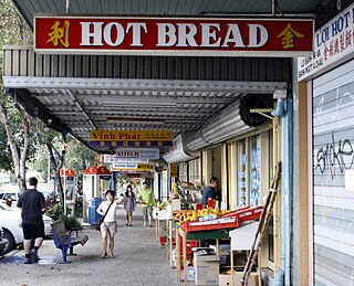
Darra is a south-western suburb in the City of Brisbane, Queensland, Australia. In the 2016 census, Darra had a population of 4,343 people.

Jindalee is a south-western residential suburb in the City of Brisbane, Queensland, Australia. In the 2021 census, Jindalee had a population of 5,320 people.

Bellbowrie is a suburb in the City of Brisbane, Queensland, Australia. In the 2021 census, Bellbowrie had a population of 5,495 people.

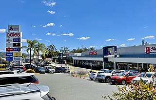
Sinnamon Park is a suburb in the City of Brisbane, Queensland, Australia. In the 2021 census, Sinnamon Park had a population of 6,590 people.

Middle Park is a residential south-western suburb in the Centenary Suburbs in the City of Brisbane, Queensland, Australia. In the 2021 census, Middle Park had a population of 3,845 people.

Westlake is a south-western suburb in the City of Brisbane, Queensland, Australia. In the 2021 census, Westlake had a population of 4,547 people.

Wacol is a suburb in the City of Brisbane, Queensland, Australia. In the 2021 census, Wacol had a population of 4,253 people.

Graceville is a suburb in the City of Brisbane, Queensland, Australia. In the 2021 census, Graceville had a population of 4,764 people.
Kenmore is a riverside suburb in the City of Brisbane, Queensland, Australia. In the 2021 census, Kenmore had a population of 9,675 people.

Mount Ommaney is a south-western riverside suburb in the City of Brisbane, Queensland, Australia. The mountain of the same name is located within the locality. In the 2021 census, Mount Ommaney had a population of 2,503 people.

Jamboree Heights is a south-western suburb in the City of Brisbane, Queensland, Australia. In the 2021 census, Jamboree Heights had a population of 3,141 people.

Tennyson is a southern riverside suburb in the City of Brisbane, Queensland, Australia. In the 2021 census, Tennyson had a population of 1,109 people.
Ellen Grove is an outer south-western suburb in the City of Brisbane, Queensland, Australia. In the 2021 census, Ellen Grove had a population of 3,586 people.

Sherwood is a suburb in the City of Brisbane, Queensland, Australia. In the 2021 census, Sherwood had a population of 6,082 people.

Seventeen Mile Rocks is a suburb in the City of Brisbane, Queensland, Australia. In the 2021 census, Seventeen Mile Rocks had a population of 2,699 people.

Richlands is an outer south-western suburb in the City of Brisbane, Queensland, Australia. In the 2021 census, Richlands had a population of 5,621 people.
Riverhills is a south-western suburb in the City of Brisbane, Queensland, Australia. It is one of the Centenary suburbs. In the 2021 census, Riverhills had a population of 4,121 people.
The Centenary Suburbs are a group of suburbs in the south-west in the City of Brisbane, Queensland, Australia. The suburbs originated as an "ambitious long-term suburban development proposal that included a number of neighbourhoods, or suburbs, each with sufficient services and facilities for its residents to have their day-to-day needs met without having to go elsewhere".

Wolston House is a heritage-listed museum and former homestead at 223 Grindle Road, Wacol, City of Brisbane, Queensland, Australia. It was built from 1852 to 1860s. It was added to the Queensland Heritage Register on 21 October 1992. It is now a historic house museum operated by the National Trust of Queensland.


