Lytton, Queensland

Last updated

Map all coordinates using: OpenStreetMap  
Lytton
Brisbane,  Queensland
Cargo ship and RML 64 pounder guns Fort Lytton Flickr 5825977624.jpg
Fort Lytton with Brisbane River in background
Australia Queensland location map.svg
Red pog.svg
Lytton
Coordinates 27°25′23″S153°09′04″E / 27.4230°S 153.1511°E / -27.4230; 153.1511 (Lytton (centre of suburb))
Population6 (2016 census) [1]
 • Density0.87/km2 (2.25/sq mi)
Postcode(s) 4178
Area6.9 km2 (2.7 sq mi)
Time zone AEST (UTC+10:00)
Location20.1 km (12 mi) ENE of Brisbane GPO
LGA(s) City of Brisbane (Wynnum Manly Ward) [2]
State electorate(s) Lytton
Federal division(s) Bonner
Suburbs around Lytton:
Pinkenba Port Of Brisbane Port Of Brisbane
Pinkenba Lytton Wynnum
Hemmant Wynnum West Wynnum

Lytton is an outer riverside suburb in the City of Brisbane, Queensland, Australia. [3] In the 2016 census, Lytton had a population of 6 people. [1]

The historical region was a significant naval base after the establishment of Fort Lytton between 1880 and 1881. The Fort safeguarded the city and shipping routes from hostile invasions during the colonial period as Brisbane was close to the French naval garrison at Nouméa. [4]

Geography

The suburb is bounded by the Brisbane River to the north-west. [5] It is 13 kilometres (8.1 mi) east of the Brisbane CBD, but travel by the railway or road is considerably longer. [6]

Lytton Hill is in the north-east of the suburb ( 27°24′51″S153°09′43″E / 27.4141°S 153.1619°E / -27.4141; 153.1619 (Lytton Hill) ) 26 metres (85 ft) above sea level. [7] [8]

Clunie Flats is a pan in the west of the suburb ( 27°25′36″S153°08′34″E / 27.4266°S 153.1427°E / -27.4266; 153.1427 (Clunie Flats) ). [9]

History

A pilot station and a village were established at Lytton in 1859. It was most likely named after Edward Bulwer-Lytton (1803–73) who was the Colonial Secretary of State in 1858–59. [6]

It would be two years before a road was surveyed from Norman Creek.[ when? ]

A telegraph line was run from Brisbane to Lytton in 1862. [6]

The hulk "Prosperine" in the Brisbane River off Lytton was used as a floating Reformatory for Boys. From 1871 to 1879 the boys were taught by the Reformatory's Sub-Inspector. From 22 July 1879 a qualified teacher was supplied by the Queensland Public Instruction Department to the Hulk "Proserpine" School, after which it was variously known as the Lytton Stockade School and the Lytton Reformatory School. In 1900 the reformatory and its school moved to Westbrook, west of Ipswich, where the facility was known as Westbrook Reformatory for Boys and the school was renamed Westbrook Reformatory School, then later renamed Westbrook Farm Home School. On 5 July 1961 the school and its primary school-aged boys moved to the Wilson Youth Hospital in Windsor, Brisbane and the school was renamed Wilson Youth Hospital School, while the older boys remained at Westbrook and had correspondence classes if desired. Wilson Youth Hospital School closed in 1968. [10]

During the years 1876–1908 a local post office was open. [6]

Due to Lytton's location on the south-east bank of the Brisbane River at its seaward end Fort Lytton was built in the 1881 to guard the mouth of the Brisbane River. The fort had a moat and was an pentagonal structure concealed behind an embankment. It was fortified with two six-inch disappearing guns, also in 1881 a rifle range was added. [6]

The layout of the village can be seen in an 1889 map. [11]

Lytton State School opened on 18 September 1882 with an initial enrolment of 41 students under teacher Mr A. S. Spencer. It was located on a 10-acre (4.0 ha) site on a hill overlooking the sea on the Old Brisbane Road, about 1.5 miles (2.4 km) from the Lytton Wharf (approx 27°25′31″S153°09′50″E / 27.4253°S 153.1638°E / -27.4253; 153.1638 (Lytton State School (former)) ). [12] [13] [14] [15] [5] In 1911, the buildings were relocated to Wynnum North and the school renamed Wynnum North State School in 1911. Wynnum North State School closed on 31 December 2010 as it was amalgamated with Lindum State School and Wynnum Central State School to create a new Wynnum State School. [10] The Wynnum North State School site was sold and redeveloped as an apartment complex. [16]

At the 2011 census, Lytton had a population of 6 people. [17]

In the 2016 census, Lytton had a population of 6 people. [1]

Heritage listings

Lytton has a number of heritage-listed sites, including:

Economy

Although Lytton was once a town, it is now primarily commercial and industrial. It shares the same postcode as the Port of Brisbane. Ampol owns and operates the Lytton Oil Refinery in the north east of the suburb ( 27°24′55″S153°09′27″E / 27.4154°S 153.1575°E / -27.4154; 153.1575 (oil refinery) ). [22] The plant could produce 109,000 barrels per day in 2012. [23]

Facilities

Wynnum Wastewater Treatment Plant is a sewage treatment plant on Tanker Street ( 27°25′06″S153°09′54″E / 27.4182°S 153.1650°E / -27.4182; 153.1650 (Wynnum Wastewater Treatment Plant) ). [22] [5] It releases treated water into Crab Creek ( 27°25′00″S153°10′00″E / 27.4166°S 153.1666°E / -27.4166; 153.1666 (Crab Creek (mouth)) ) which flows into Moreton Bay. [24] [25]

Amenities

There are a number of parks in Lytton, including:

See also

Related Research Articles

<span class="mw-page-title-main">Kangaroo Point, Queensland</span> Suburb of Brisbane, Queensland, Australia

Kangaroo Point is an inner southern suburb in the City of Brisbane, Queensland, Australia. In the 2016 census, Kangaroo Point had a population of 8,063 people.

<span class="mw-page-title-main">Morningside, Queensland</span> Suburb of Brisbane, Queensland, Australia

Morningside is a suburb in the City of Brisbane, Queensland, Australia. In the 2016 census, Morningside had a population of 10,481.

<span class="mw-page-title-main">Tingalpa, Queensland</span> Suburb of Brisbane, Queensland, Australia

Tingalpa is a suburb in the City of Brisbane, Queensland, Australia. In the 2016 census, Tingalpa had a population of 8,290 people.

<span class="mw-page-title-main">Pinkenba, Queensland</span> Suburb of Brisbane, Queensland, Australia

Pinkenba is a town and eastern coastal suburb within the City of Brisbane, Queensland, Australia. In the 2016 census, Pinkenba had a population of 368 people.

<span class="mw-page-title-main">New Farm, Queensland</span> Suburb of Brisbane, Queensland, Australia

New Farm is an inner northern riverside suburb in the City of Brisbane, Queensland, Australia. In the 2021 census, New Farm had a population of 12,454 people.

<span class="mw-page-title-main">Wynnum, Queensland</span> Suburb of Brisbane, Queensland, Australia

Wynnum is a coastal suburb in the City of Brisbane, Queensland, Australia. In the 2016 census, Wynnum had a population of 12,915 people. The suburb is a popular destination in Brisbane due to its coastline, jetty and tidal wading pool.

<span class="mw-page-title-main">Murarrie, Queensland</span> Suburb of Brisbane, Queensland, Australia

Murarrie is an eastern riverside suburb in the City of Brisbane, Queensland, Australia. In the 2016 census, Murarrie had a population of 4,303 people. Queensport is a neighbourhood within Murarrie. Gibson Island is a neighbourhood within Murarrie and, despite its name, is no longer an island.

<span class="mw-page-title-main">Manly, Queensland</span> Suburb of Brisbane, Queensland, Australia

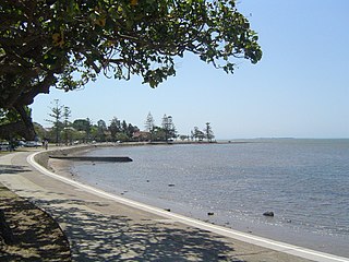
Manly is an eastern bayside suburb in the City of Brisbane, Queensland, Australia. In the 2016 census, Manly had a population of 4,064 people.

<span class="mw-page-title-main">Yeronga, Queensland</span> Suburb of Brisbane, Queensland, Australia

Yeronga is a southern riverside suburb in the City of Brisbane, Queensland, Australia. In the 2016 census, Yeronga had a population of 6,535 people.

<span class="mw-page-title-main">Norman Park, Queensland</span> Suburb of Brisbane, Queensland, Australia

Norman Park is a suburb in the City of Brisbane, Queensland, Australia. In the 2021 census, Norman Park had a population of 6,842 people.

<span class="mw-page-title-main">East Brisbane, Queensland</span> Suburb of Brisbane, Queensland, Australia

East Brisbane is an inner southern suburb of the City of Brisbane, Queensland, Australia. In the 2016 census, East Brisbane had a population of 5,934 people.

<span class="mw-page-title-main">Hamilton, Queensland</span> Suburb of Brisbane, Queensland, Australia

Hamilton is an affluent riverside mixed-use suburb in the north-east of the City of Brisbane, Queensland, Australia. Hamilton is located along the north bank of the Brisbane River. In the 2016 census, Hamilton had a population of 6,995 people.

<span class="mw-page-title-main">Wynnum West, Queensland</span> Suburb of Brisbane, Queensland, Australia

Wynnum West and Lindum are outer eastern suburb in the City of Brisbane, Queensland, Australia. In the 2016 census, Wynnum West including the locality of Lindum had a population of 12,292 people.

<span class="mw-page-title-main">Manly West, Queensland</span> Suburb of Brisbane, Queensland, Australia

Manly West is a suburb in the City of Brisbane, Queensland, Australia. In the 2016 census, Manly West had a population of 11,978 people.

<span class="mw-page-title-main">Lota, Queensland</span> Suburb of Brisbane, Queensland, Australia

Lota is an eastern outer coastal suburb in the City of Brisbane, Queensland, Australia. In the 2016 census, Lota had a population of 3,256 people.

<span class="mw-page-title-main">Hemmant, Queensland</span> Suburb of Brisbane, Queensland, Australia

Hemmant is a suburb of the City of Brisbane, Queensland, Australia. In the 2016 census, Hemmant had a population of 2,385 people.

<span class="mw-page-title-main">Cannon Hill, Queensland</span> Suburb of Brisbane, Queensland, Australia

Cannon Hill is a suburb in the City of Brisbane, Queensland, Australia. In the 2016 census, Cannon Hill had a population of 5,533 people.

<span class="mw-page-title-main">Ransome, Queensland</span> Suburb of Brisbane, Queensland, Australia

Ransome is an outer coastal suburb in the City of Brisbane, Queensland, Australia. In the 2016 census, Ransome had a population of 405 people.

<span class="mw-page-title-main">Westbrook, Queensland</span> Suburb of Toowoomba Region, Queensland, Australia

Westbrook is a rural town and locality in the Toowoomba Region, Queensland, Australia. In the 2016 census, the locality of Westbrook had a population of 3,885 people.

The Westbrook Reformatory for Boys was a reformatory school in the town of Westbrook, in the Toowoomba Region, Queensland, in Australia. The Westbrook Reformatory was created in 1900 after the closure of earlier versions of the institution on the former prison hulk, the Proserpine, and at Lytton, Queensland. The Reformatory changed its name to the Westbrook Farm Home for Boys in 1919. Under this later name, it was the subject of a major scandal which culminated in a government inquiry. The institution was renamed twice more before its closure in 1994. Since its closure, the Westbrook institution has become known as a site of serious institutional abuse. It was described at length in the 1999 Forde Inquiry and the 2004 Forgotten Australians report.

References

  1. 1 2 3 Australian Bureau of Statistics (27 June 2017). "Lytton (SSC)". 2016 Census QuickStats. Retrieved 20 October 2018. OOjs UI icon edit-ltr-progressive.svg
  2. "Wynnum Manly Ward". Brisbane City Council. Archived from the original on 12 March 2017. Retrieved 12 March 2017.
  3. "Lytton – suburb in City of Brisbane (entry 43599)". Queensland Place Names. Queensland Government . Retrieved 26 December 2020.
  4. "Culture and History". Queensland Government Parks and Forests. Archived from the original on 15 July 2019. Retrieved 15 July 2019.
  5. 1 2 3 "Queensland Globe". State of Queensland . Retrieved 8 April 2022.
  6. 1 2 3 4 5 "Lytton | Queensland Places". queenslandplaces.com.au. Archived from the original on 30 October 2020. Retrieved 27 October 2020.
  7. "Mountain peaks and capes - Queensland". Queensland Open Data. Queensland Government. 12 November 2020. Archived from the original on 25 November 2020. Retrieved 25 November 2020.
  8. "Lytton Hill – mountain in Brisbane City (entry 20322)". Queensland Place Names. Queensland Government . Retrieved 25 November 2020.
  9. "Clunie Flats – pan in City of Brisbane (entry 7514)". Queensland Place Names. Queensland Government . Retrieved 26 December 2020.
  10. 1 2 Queensland Family History Society (2010), Queensland schools past and present (Version 1.01 ed.), Queensland Family History Society, ISBN   978-1-921171-26-0
  11. "Brisbane River Improvements sheet 2". Queensland Government (Map). 1889. Archived from the original on 16 July 2020. Retrieved 17 July 2020.
  12. "HEMMANT". The Brisbane Courier . Vol. XXXVII, no. 7, 710. Queensland, Australia. 27 September 1882. p. 5. Archived from the original on 8 April 2022. Retrieved 8 April 2022 via National Library of Australia.
  13. "Plan of Lytton Town and adjacent country" (Map). Queensland Government. 1886. Archived from the original on 11 February 2021. Retrieved 8 April 2022.
  14. "Dunlops Touring Map of Brisbane and Environs" (Map). Queensland Government. 1919. Retrieved 8 April 2022.
  15. "Moreton 40 Chain map AG2 series sheet 2 east" (Map). Queensland Government. 1927. Archived from the original on 14 January 2021. Retrieved 8 April 2022.
  16. "Wynnum North State School". Mapping Brisbane History. Retrieved 8 April 2022.
  17. Australian Bureau of Statistics (31 October 2012). "Lytton (State Suburb)". 2011 Census QuickStats. Retrieved 24 October 2013. OOjs UI icon edit-ltr-progressive.svg
  18. "Heavy Anti-Aircraft Gun Station 385, Lytton (entry 650230)". Queensland Heritage Register . Queensland Heritage Council. Retrieved 16 December 2022.
  19. "Lytton Hill (entry 601366)". Queensland Heritage Register . Queensland Heritage Council. Retrieved 6 July 2013.
  20. "Fort Lytton (entry 600248)". Queensland Heritage Register . Queensland Heritage Council. Retrieved 6 July 2013.
  21. "Lytton Quarantine Station (former) (entry 601347)". Queensland Heritage Register . Queensland Heritage Council. Retrieved 6 July 2013.
  22. 1 2 "Landmark Areas - Queensland". Queensland Open Data. Queensland Government. 18 November 2020. Archived from the original on 21 November 2020. Retrieved 21 October 2020.
  23. Jessica Jaganathan (22 February 2012). "Caltex Australia to shut crude unit at Lytton refinery in H1". Reuters. Thomson Reuters. Archived from the original on 14 February 2015. Retrieved 14 February 2015.
  24. "Wynnum Wastewater Treatment Plant". Wynnum Wastewater Treatment Plant. Queensland Government. 14 November 2019. Archived from the original on 30 March 2019. Retrieved 26 February 2021.
  25. "Crab Creek – watercourse in City of Brisbane (entry 8639)". Queensland Place Names. Queensland Government . Retrieved 26 December 2020.
  26. 1 2 3 "Land for public recreation - Queensland". Queensland Open Data. Queensland Government. 20 November 2020. Archived from the original on 22 November 2020. Retrieved 22 November 2020.