Yeerongpilly, Queensland

Last updated

Yeerongpilly
Brisbane,  Queensland
Station Road, Yeerongpilly 20230726 123711.jpg
Station Road Industrial Area
Australia Queensland location map.svg
Red pog.svg
Yeerongpilly
Coordinates 27°31′48″S153°00′43″E / 27.5300°S 153.0119°E / -27.5300; 153.0119 (Yeerongpilly (centre of suburb))
Population1,934 (2016 census) [1]
 • Density1,018/km2 (2,640/sq mi)
Postcode(s) 4105
Area1.9 km2 (0.7 sq mi)
Time zone AEST (UTC+10:00)
Location8.5 km (5 mi) SW of Brisbane GPO
LGA(s) City of Brisbane
(Tennyson Ward) [2]
State electorate(s) Miller
Federal division(s) Moreton
Suburbs around Yeerongpilly:
Indooroopilly Yeronga Annerley
Tennyson Yeerongpilly Moorooka
Rocklea Rocklea Moorooka

Yeerongpilly is a southern suburb in the City of Brisbane, Queensland, Australia. [3] In the 2016 census, Yeerongpilly had a population of 1,934 people. [1]

Contents


Geography

Yeerongpilly is 8.5 kilometres (5.3 mi) south-west of the Brisbane GPO. [4]

A small section of the north eastern boundary runs along Ipswich Road.

Fairfield Road Fairfield Road, Yeerongpilly, Queensland.jpg
Fairfield Road

History

Yeerongpilly is an Aboriginal word meaning rain coming according to Thomas Petrie [5] or is derived from the Aboriginal words yurong meaning rain or yarung meaning sandy or gravelly. The suffix "pilly" means a gully or watercourse. [3]

Yeerongpilly grew from an area named Boggo, [3] which was logged for timber for Brisbane.[ citation needed ]

In April 1885, "Lathorn Estate" made up of 118 allotments were advertised to be auctioned by James R. Dickson & Co. A map advertising the auction states the Estate consisted of 118 subdivisions of 131 Portion, Parish of Yeerongpilly. [6] Newspaper advertising states the Estate was "situated at the junction of Ipswich and Boggo Roads" and "within a quarter of a mile of Yeerong Railway Station". [7]

In October 1887, 24 large allotments of the "Ortive Estate" were advertised to be auctioned by G. T. Bell, Auctioneer. A map advertising the auction states the Estate was "close to South Coast Junction Railway Station." [8] Newspaper advertising states the Estate was "within stone throw of railway station" with "24 grand large-sized building allotments, all over 20 perches". [9]

In February 1890, "Grand View Estate" made up of 18 allotments were advertised to be auctioned by John W. Todd. A map advertising the auction states the Estate was bordered by Fairfield Road and Boundary Road. [10] Newspaper advertising states the Estate was "directly opposite the South Brisbane cemetery" and offers "magnificent views of the River, Mountains and surrounding land." [11]

Golfers tee off at the Brisbane Golf Club Championship Tournament at Yeerongpilly Links, Brisbane, 1910 StateLibQld 2 118032 Golfers tee off at the Brisbane Golf Club Championship Tournament at Yeerongpilly Links, Brisbane, 1910.jpg
Golfers tee off at the Brisbane Golf Club Championship Tournament at Yeerongpilly Links, Brisbane, 1910

The Brisbane Golf Club was established in the suburb in 1896. [12]

A Queensland Government research complex, last known as the Animal Research Institute, occupied a site adjacent to Fairfield Road from 1909 to 2011.

In October 1927, 14 allotments of "Riverside Estate" were advertised to be auctioned by Thornton & Pearce, Auctioneers. A map advertising the auction states that the Estate was "only a few yards from Tennyson station, within easy walking distance". [13] Newspaper advertising states the Estate allotments were "the last of the select, High River frontage sites" with "appealing views of the river and mountains". [14]

2010-2011 Queensland floods Flooding near the Queensland Tennis Centre and government Animal Research Centre, Yeerongpilly.jpg
2010–2011 Queensland floods

The Brisbane River makes up a very small section of the northern boundary of the locality while a small section of the western boundary follows Oxley Creek. [15] Parts of Yeerongpilly were affected by the 2010–2011 Queensland floods. Insurance claims for damage created by the flood were the second highest in the state, according to Suncorp Insurance. [16]

Demographics

In the 2016 census, Yeerongpilly had a population of 1,934 people, 50.8% female and 49.2% male. [1] The median age of the Yeerongpilly population was 32 years. The most common ancestries in Yeerongpilly were English 25.9%, Australian 21.0%, Irish 11.6%, Scottish 8.5% and German 4.0%. In Yeerongpilly (State Suburbs), 70.2% of people were born in Australia. The most common countries of birth were New Zealand 3.6%, England 3.4%, India 1.9%, Vietnam 1.5% and China (excludes SARs and Taiwan) 1.3%. 78.1% of people only spoke English at home. Other languages spoken at home included Vietnamese 2.1%, Mandarin 1.4%, Arabic 1.1%, Cantonese 1.0% and Spanish 0.9%. [1]

Heritage listings

Animal Research Institute Animal Research Institute, Yeerongpilly.jpg
Animal Research Institute

Yeerongpilly has a number of heritage-listed sites, including:

Education

There are no schools in Yeerongpilly. The nearest primary school is Yeronga State School in Yeronga to the north. The nearest secondary school is Yeronga State High School in Yeronga. [15]

Transport

Yeerongpilly railway station, 2019 Yeerongpilly railway station, Queensland, 2019.jpg
Yeerongpilly railway station, 2019

Yeerongpilly railway station provides access to regular Queensland Rail City network services to Brisbane, Beenleigh and Ferny Grove.

The original proposal for the Cross River Rail project was to have its southern tunnel portal approximately at the Cardross St overbridge. The current proposal has relocated the southern tunnel portal to Dutton Park.

Sport

The Brisbane Golf Club is a 36 hole, private golf club and includes facilities such as driving range and pro shop. [12]

Notable people

See also

Related Research Articles

<span class="mw-page-title-main">Alderley, Queensland</span> Suburb of Brisbane, Queensland, Australia

Alderley is a northern suburb in the City of Brisbane, Queensland, Australia. In the 2016 census, Alderley had a population of 6,117 people.

<span class="mw-page-title-main">Annerley</span> Suburb of Brisbane, Queensland, Australia

Annerley is a suburb in the City of Brisbane, Queensland, Australia. In the 2016 census, Annerley had a population of 11,336 people.

<span class="mw-page-title-main">Moorooka, Queensland</span> Suburb of Brisbane, Queensland, Australia

Moorooka is a southern suburb in the City of Brisbane, Queensland, Australia. In the 2016 census, Moorooka had a population of 10,368 people.

<span class="mw-page-title-main">Fairfield, Queensland</span> Suburb of Brisbane, Queensland, Australia

Fairfield is a suburb of the City of Brisbane, Queensland, Australia. In the 2021 census, Fairfield had a population of 3,106 people.

<span class="mw-page-title-main">Clayfield, Queensland</span> Suburb of Brisbane, Queensland, Australia

Clayfield is a suburb in the City of Brisbane, Queensland, Australia. In the 2016 census, Clayfield had a population of 10,555 people.

<span class="mw-page-title-main">Woolloongabba</span> Suburb of Brisbane, Queensland, Australia

Woolloongabba is a suburb in the City of Brisbane, Queensland, Australia. In the 2016 census, Woolloongabba had a population of 5,631 people.

<span class="mw-page-title-main">Rocklea, Queensland</span> Suburb of Brisbane, Queensland, Australia

Rocklea is a suburb in the City of Brisbane, Queensland, Australia. In the 2016 census, Rocklea had a population of 1,595 people.

<span class="mw-page-title-main">Chelmer, Queensland</span> Suburb of Brisbane, Queensland, Australia

Chelmer is a south-western suburb in the City of Brisbane, Queensland, Australia. In the 2016 census, Chelmer had a population of 2,998 people.

<span class="mw-page-title-main">Corinda, Queensland</span> Suburb of Brisbane, Queensland, Australia

Corinda is a suburb in the City of Brisbane, Queensland, Australia. In the 2016 census, Corinda had a population of 5,064 people.

<span class="mw-page-title-main">Yeronga, Queensland</span> Suburb of Brisbane, Queensland, Australia

Yeronga is a southern riverside suburb in the City of Brisbane, Queensland, Australia. In the 2016 census, Yeronga had a population of 6,535 people.

<span class="mw-page-title-main">Auchenflower, Queensland</span> Suburb of Brisbane, Queensland, Australia

Auchenflower is an inner suburb of the City of Brisbane, Queensland, Australia. As of the 2021 census, Auchenflower had a total population of 5,670.

<span class="mw-page-title-main">Banyo, Queensland</span> Suburb of Brisbane, Queensland, Australia

Banyo is a northern suburb in the City of Brisbane, Queensland, Australia. In the 2016 census, Banyo had a population of 5,868 people.

<span class="mw-page-title-main">Graceville, Queensland</span> Suburb of Brisbane, Queensland, Australia

Graceville is a suburb in the City of Brisbane, Queensland, Australia. In the 2016 census, Graceville had a population of 4,634 people.

<span class="mw-page-title-main">Hamilton, Queensland</span> Suburb of Brisbane, Queensland, Australia

Hamilton is an affluent riverside mixed-use suburb in the north-east of the City of Brisbane, Queensland, Australia. Hamilton is located along the north bank of the Brisbane River. In the 2016 census, Hamilton had a population of 6,995 people.

<span class="mw-page-title-main">Bulimba, Queensland</span> Suburb of Brisbane, Queensland, Australia

Bulimba is a suburb in the City of Brisbane, Queensland, Australia. In the 2016 census, Bulimba had a population of 6,843 people.

<span class="mw-page-title-main">Hawthorne, Queensland</span> Suburb of Brisbane, Queensland, Australia

Hawthorne is a suburb of the City of Brisbane, Queensland, Australia. In the 2016 census, Hawthorne had a population of 4,989 people.

<span class="mw-page-title-main">Tennyson, Queensland</span> Suburb of Brisbane, Queensland, Australia

Tennyson is a southern riverside suburb in the City of Brisbane, Queensland, Australia. In the 2016 census, Tennyson had a population of 1,019 people.

<span class="mw-page-title-main">Sherwood, Queensland</span> Suburb of Brisbane, Queensland, Australia

Sherwood is a suburb in the City of Brisbane, Queensland, Australia. In the 2016 census, Sherwood had a population of 5,313 people.

<span class="mw-page-title-main">Salisbury, Queensland</span> Suburb of Brisbane, Queensland, Australia

Salisbury is a southern suburb in the City of Brisbane, Queensland, Australia. In the 2016 census, Salisbury had a population of 6,290 people.

<span class="mw-page-title-main">Shire of Stephens</span> Local government area in Queensland, Australia

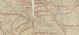
The Shire of Stephens was a local government area in the inner southern suburbs of Brisbane, Queensland, Australia. The shire, administered from Annerley, covered an area of 9 square miles (23 km2), and existed as a local government entity from 1886 until 1925, when it was amalgamated into the City of Brisbane under the City of Brisbane Act 1924.

References

  1. 1 2 3 4 Australian Bureau of Statistics (27 June 2017). "Yeerongpilly (SSC)". 2016 Census QuickStats. Retrieved 20 October 2018. OOjs UI icon edit-ltr-progressive.svg
  2. "Tennyson Ward". Brisbane City Council. Archived from the original on 4 March 2017. Retrieved 19 March 2017.
  3. 1 2 3 "Yeerongpilly – suburb in City of Brisbane (entry 44352)". Queensland Place Names. Queensland Government . Retrieved 11 October 2020.
  4. "Brisbane GPO to Yeerongpilly". Google Maps . Archived from the original on 16 October 2020. Retrieved 16 October 2020.
  5. "NOMENCLATURE OF QUEENSLAND—320". The Courier-mail . No. 970. Queensland, Australia. 8 October 1936. p. 12. Archived from the original on 16 October 2020. Retrieved 16 October 2020 via National Library of Australia.
  6. "Lathorn Estate Being subdivisions 1 to 118 of portions 131 Parish of Yeerongpilly. For sale by auction on the ground Saturday April 25th at 2:30 p.m. Luncheon provided". State Library of Queensland. 1885. hdl:10462/deriv/18504. Archived from the original on 16 October 2020. Retrieved 5 June 2020.
  7. "Classified Advertising". The Brisbane Courier . Queensland, Australia. 24 April 1885. p. 7. Archived from the original on 16 October 2020. Retrieved 5 June 2020 via Trove.
  8. "The Ortive Estate". State Library of Queensland. 1887. Archived from the original on 25 May 2022. Retrieved 18 May 2022.
  9. "Classified Advertising". The Brisbane Courier . Vol. XLIV, no. 9, 295. Queensland, Australia. 29 October 1887. p. 10. Retrieved 18 May 2022 via National Library of Australia.
  10. "Plan of the Grand View Estate". State Library of Queensland. 1890. hdl:10462/deriv/280864. Archived from the original on 16 October 2020. Retrieved 5 June 2020.
  11. "Advertising". The Telegraph . Queensland, Australia. 25 January 1890. p. 8. Archived from the original on 16 October 2020. Retrieved 5 June 2020 via Trove.
  12. 1 2 "The Brisbane Golf Club Australia". Archived from the original on 11 November 2012. Retrieved 21 October 2014.
  13. "Riverside Estate, Yeerongpilly Thornton & Pearce, Auctioneers ; C.F. Bennett, Surveyor". State Library of Queensland. 1927. Archived from the original on 25 May 2022. Retrieved 18 May 2022.
  14. "Advertising". The Brisbane Courier . No. 21, 757. Queensland, Australia. 20 October 1927. p. 26. Archived from the original on 25 May 2022. Retrieved 18 May 2022 via National Library of Australia.
  15. 1 2 "Queensland Globe". State of Queensland . Retrieved 16 October 2020.
  16. "Insurer's flood payouts top $63m". Australia: ABC News. 3 November 2011. Archived from the original on 4 November 2011. Retrieved 10 October 2012.
  17. "Trainmen's Quarters". Brisbane Heritage Register. Brisbane City Council . Retrieved 9 March 2020.
  18. "Animal Research Institute (former) (entry 602598)". Queensland Heritage Register . Queensland Heritage Council. Retrieved 19 June 2013.
  19. "14 Grosvenor Street, Yeerongpilly". Brisbane Heritage Register. Brisbane City Council . Retrieved 9 March 2020.
  20. "St Giles Uniting Church (former)". Brisbane Heritage Register. Brisbane City Council . Retrieved 9 March 2020.
  21. "12 Tees Street, Yeerongpilly". Brisbane Heritage Register. Brisbane City Council . Retrieved 9 March 2020.
  22. "Brisbane Golf Club Clubhouse". Brisbane Heritage Register. Brisbane City Council . Retrieved 9 March 2020.
  23. "32 Wingarra Street, Yeerongpilly". Brisbane Heritage Register. Brisbane City Council . Retrieved 9 March 2020.