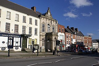
Ashbourne is a market town in the Derbyshire Dales, England, with a population of 7,112 in the 2011 census. It contains many historical buildings and independently owned shops, and offers a historic annual Shrovetide football match. Its position near the southern edge of the Peak District makes it the closest town to Dovedale, to which it is sometimes referred as the gateway.

The Cromford and High Peak Railway (C&HPR) in Derbyshire, England, was completed in 1831, to carry minerals and goods between the Cromford Canal wharf at High Peak Junction and the Peak Forest Canal at Whaley Bridge. It dealt with the hilly rural terrain by using a number of inclines. It was closed by 1967, and the majority of the route, between Dowlow and Cromford, has become the High Peak Trail, a route on the National Cycle Network.

The High Peak Trail is a 17-mile (27 km) trail for walkers, cyclists and horse riders in the Peak District of England. Running from Dowlow (53.2059°N 1.8349°W), near Buxton, to High Peak Junction, Cromford (53.1004°N 1.5354°W), it follows the trackbed of the former Cromford and High Peak Railway, which was completed in 1831 to carry minerals and goods between the Cromford Canal wharf at High Peak Junction and the Peak Forest Canal at Whaley Bridge.

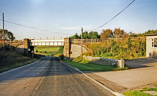
The Tissington Trail is a bridleway, footpath and cycleway in Derbyshire, England, along part of the trackbed of the former railway line connecting Ashbourne to Buxton. It takes its name from the village of Tissington, which it skirts. Opened in 1971, and now a part of the National Cycle Network, it stretches for 13 miles (21 km) from Parsley Hay (53.1706°N 1.7828°W) in the north to Ashbourne (53.0196°N 1.7397°W) in the south.

The Pennine Bridleway is a National Trail in Northern England.

The Limestone Way is a waymarked long-distance footpath in Derbyshire, England. It runs for 46 miles (74 km) through the White Peak of the Peak District National Park, from Castleton south to Rocester over the county boundary into Staffordshire. The trail is named for the limestone scenery along its route. It was devised by Brian Spencer of Matlock Rotary Club and developed and opened in 1986 by the West Derbyshire District Council. It originally ran to Matlock, but was extended to its current, longer route in 1992 to join up with the Staffordshire Way.

Thorpe is a village and civil parish in the English county of Derbyshire; it is on the Derbyshire/Staffordshire border, on the east bank of the River Dove, about four miles north of Ashbourne. The population of the civil parish as at the 2011 census was 183.

Parsley Hay railway station served Parsley Hay, a hamlet about 9.3 miles (15 km) south east of Buxton, Derbyshire, on the LNWR line to Ashbourne. The nearest large settlement is the village of Hartington.
The Ashbourne line was a 33 1⁄2 mi (53.9 km) railway from Buxton via Ashbourne to Uttoxeter. It was built by the London and North Western Railway using a section of the Cromford and High Peak Railway (C&HPR) and it joined the North Staffordshire Railway at Ashbourne, proceeding to Uttoxeter with a junction onto the main line at Rocester.

Higher Buxton railway station was opened in 1894 to the south east of Buxton, Derbyshire, on the LNWR line to Ashbourne and the south.
Hindlow railway station was opened for goods in 1833 near to Hindlow near King Sterndale to the south east of Buxton, Derbyshire on the Cromford and High Peak Railway and the LNWR line to Ashbourne and the south.

Dowlow Halt was opened in 1920 between Dowlow and Greatlow to the south east of Buxton, Derbyshire on the London and North Western Railway line to Ashbourne and the south.
Hurdlow railway station was near to the hamlet of Hurdlow to the south east of Buxton, Derbyshire on the LNWR line to Ashbourne and the south.
Norbury and Ellaston railway station was on a branch of the North Staffordshire Railway between Rocester and Ashbourne. The station, which had a waiting room, ticket office, and stationmaster's office, and two side platforms, opened at Norbury, Derbyshire in 1852.
Thorpe Cloud railway station was opened in 1899 between the villages of Thorpe and Fenny Bentley in Derbyshire, south east of Buxton.
Alsop en le Dale railway station was opened in 1899 near Alsop en le Dale and Alstonefield, villages in Derbyshire southeast of Buxton.

Hartington railway station opened in 1899 about two miles away from the village it served - Hartington in Derbyshire, south east of Buxton.

Ashbourne railway station formerly served the town of Ashbourne in Derbyshire. There have been two stations in the town. The first, opened in 1852, was operated by the North Staffordshire Railway (NSR); it was replaced in 1899 by a station at a new location, jointly operated by the NSR and the London and North Western Railway (LNWR). In 1923 the station passed into the ownership of the London, Midland and Scottish Railway and in 1948 that of the London Midland Region of British Railways. It was finally closed to all traffic in 1963.

High Peak Junction, near Cromford, Derbyshire, England, is the name now used to describe the site where the former Cromford and High Peak Railway (C&HPR), whose workshops were located here, meets the Cromford Canal. It lies within Derwent Valley Mills World Heritage Site, designated in 2001, and today marks the southern end of the High Peak Trail, a 17 miles (27 km) trail for walkers, cyclists and horse riders. The Derwent Valley Heritage Way also passes this point, and popular walks lead from here along the towpath in both directions.
The White Peak Loop is a 60-mile (97 km) route for walking, cycling and horse riding in the Peak District of England. The trail combines sections of the High Peak Trail and the Monsal Trail with linking sections through the towns of Buxton, Bakewell and Matlock. The White Peak Loop is being developed by Derbyshire County Council and as of 2020 some sections are not yet complete.
