Una, Himachal Pradesh

Last updated

Una
Una railway - Jarapaga viaduct (2007).jpg
India Himachal Pradesh location map.svg
Red pog.svg
Una
Location in Himachal Pradesh, India
Coordinates: 31°28′05″N76°16′16″E / 31.468°N 76.271°E / 31.468; 76.271
CountryFlag of India.svg  India
State Himachal Pradesh
District Una
Elevation
369 m (1,211 ft)
Population
 (2011)
  Total18,722
  Rank 10 in HP
Languages
  Official Hindi
  Other spoken Punjabi, Pahari
Time zone UTC+5:30 (IST)
Vehicle registration HP-19, HP-19AA, HP-20, HP-72HP-78, HP-80
Website hpuna.nic.in

Una is a City and a Municipal Council in Una district in the Indian state of Himachal Pradesh. It serves as the headquarters of Una district. There are 11 wards under Municipal Council. Una City is home to the Kila, which is a historical fort and an ancestral home of the descendants of the first guru of the Sikhs, Guru Nanak. [1]

Contents

Geography and climate

Una is located at 31°29′N76°17′E / 31.48°N 76.28°E / 31.48; 76.28 . [2] It has an average elevation of 369 metres (1,210 feet). The elevation keeps temperatures cooler than surrounding lowlands, however, the area still experiences temperatures up to 45 °C (113 °F). [3]

Climate data for Una (1985–2010, extremes 1985–2011)
MonthJanFebMarAprMayJunJulAugSepOctNovDecYear
Record high °C (°F)31.0
(87.8)
34.2
(93.6)
39.4
(102.9)
43.2
(109.8)
45.2
(113.4)
45.2
(113.4)
42.2
(108.0)
38.4
(101.1)
38.6
(101.5)
35.6
(96.1)
33.4
(92.1)
28.2
(82.8)
45.2
(113.4)
Mean daily maximum °C (°F)19.9
(67.8)
23.1
(73.6)
28.1
(82.6)
34.3
(93.7)
37.8
(100.0)
37.9
(100.2)
33.8
(92.8)
32.8
(91.0)
32.8
(91.0)
31.1
(88.0)
27.4
(81.3)
22.3
(72.1)
30.1
(86.2)
Mean daily minimum °C (°F)3.2
(37.8)
5.7
(42.3)
9.4
(48.9)
13.5
(56.3)
18.2
(64.8)
21.2
(70.2)
22.1
(71.8)
21.9
(71.4)
20.1
(68.2)
13.8
(56.8)
8.2
(46.8)
4.0
(39.2)
13.5
(56.3)
Record low °C (°F)−5.8
(21.6)
−1.6
(29.1)
3.0
(37.4)
6.7
(44.1)
8.6
(47.5)
14.7
(58.5)
17.0
(62.6)
16.3
(61.3)
13.2
(55.8)
5.1
(41.2)
1.8
(35.2)
−2.4
(27.7)
−5.8
(21.6)
Average rainfall mm (inches)37.0
(1.46)
42.4
(1.67)
42.3
(1.67)
24.9
(0.98)
37.1
(1.46)
89.6
(3.53)
323.2
(12.72)
320.3
(12.61)
162.2
(6.39)
21.1
(0.83)
10.7
(0.42)
20.4
(0.80)
1,131.2
(44.54)
Average rainy days2.43.43.31.62.75.511.611.65.81.20.91.251.2
Average relative humidity (%) (at 17:30 IST)65635742414968726761586159
Source: India Meteorological Department [4] [5]

Demographics

Religions in Una City (2011) [6]
ReligionPercent
Hindus
91.38%
Sikhs
6.93%
Muslims
1.05%
Distribution of religions

According to the 2011 Census of India, Una town had a population of 18,722 with 9,851 males and 8,871 females. [7] The literacy rate was 86.21%, higher than the state average of 82.80%. [7] The male literacy and female literacy rates were 88.84 and 83.29% respectively. There were 1,954 children below the age of six years. The sex ratio and child sex ratio of the town stood at 901 and 918 respectively. [7] Punjabi and Pahari are the main spoken languages.

Transport

Roadways

Una serves as one of the main entry points to the rest of Himachal Pradesh through the borders of Punjab at Nangal-Mehetpur checkpoint. Una is well connected with the rest of the state, Himachal Pradesh and rest of India through National Highway 503 and National Highway 503A. [8]

Railways

Una Himachal Railway Station is well Connected with Chandigarh Junction and Capital Of India "New Delhi" through Express and Mails Trains and some other trains connected it with Ambala Cantt.Junction

Nearest Airport's and Distance

Gaggal ( Kangra ) Domestic Airport (114 km)

Chandigarh International Airport ( 127 km )

Famous Places

Chintpurni Temple  : This is one of the most famous temples in the Una district of Himachal Pradesh. It is situated on the Dharamshala-Hoshiarpur road. It is visited by thousands of devotees, mostly from Himachal Pradesh and Punjab. Chintpurni temple, as the name suggests, is devoted to the Supreme Goddess Durga.

Kutlehar Fort: Also known as the Forts of Solasingi, is a group of forts in the Una district of Himachal Pradesh.

Dera Baba Gurbarbhag Singh [9] : It is situated in village Mairi, which is 42 Km away from the Una city.

Dera Baba Shri Chand Ji Maharaj Pubowal: This famous and beautiful religious place is devoted to Baba Shri Chand ji the founder of Udasin Samparday and the elder son of Shri Guru Nanak dev ji situated 17Km away from the district Una headquarters in Pubowal village of Haroli tehsil. This place was founded in 1980 by Sant Santosh Dass Ji in his childhood at the age of 9 years. Thousands of devotees visit here to get blessings of Dhan Dhan Baba Shri Chand ji maharaj. This place is spreading awareness about the Gurubani and Naam since 1980.

Related Research Articles

<span class="mw-page-title-main">Sukhmani Sahib</span> Set of hymns in the Guru Granth Sahib, the main scripture of Sikhism

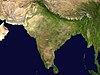
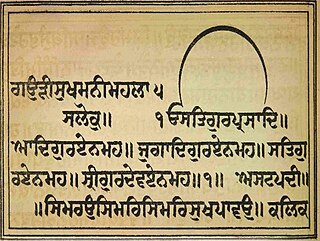
Sukhmani Sahib, known under the title of Gauri Sukhmani in the scripture, is usually translated to mean Prayer of Peace is a set of 192 padas present in the holy Guru Granth Sahib, the main scripture and living Guru of Sikhism from Ang 262 to Ang 296. This Gurbani text was written by the 5th Guru, Guru Arjan (1563–1606) at Amritsar in around 1602. Guru Arjan first recited the bani at Gurdwara Barth Sahib in the Gurdaspur district of Punjab, India.

Bilaspur is a town and a municipal council in Bilaspur district in the Indian state of Himachal Pradesh.

<span class="mw-page-title-main">Kapurthala</span> City in Punjab, India

Kapurthala is a city in Punjab state of India. It is the administrative headquarters of Kapurthala District. It was the capital of the Kapurthala State, a princely state in British India. The aesthetic mix of the city with its prominent buildings based on French and Indo-Saracenic architecture self-narrate its princely past. It is also known as city of Palaces & Gardens. According to the 2011 census, Kapurthala is the least populated city in India.

<span class="mw-page-title-main">Mehta Kalu</span> Father of the first Sikh guru

Mehta Kalu, formally Kalyan Das, (1440–1522) was the father of Guru Nanak, the founder of Sikhism.

<span class="mw-page-title-main">Batala</span> City in Punjab, India

Batala is the eighth largest city in the state of Punjab, India in terms of population after Ludhiana, Amritsar, Jalandhar, Patiala, Bathinda, Mohali and Hoshiarpur. Batala ranks as the second-oldest city after Bathinda. It is a municipal corporation in Gurdaspur district in the Majha region of the state of Punjab. It is located about 32 km from Gurdaspur, the headquarters of the district. It is also a Police district. Batala holds the status of the most populated town of the district with 31% of the district's total population. It is the biggest industrial town in the district.

Paonta Sahib is an industrial town of Himachal Pradesh in India. It is located in the south of Sirmaur district, on National Highway 72. Paonta Sahib is an important place of worship for Sikhs, hosting a large Gurdwara named Gurudwara Paonta Sahib, on the banks of the river Yamuna. The river is the boundary between the states of Himachal Pradesh and Uttarakhand.

<span class="mw-page-title-main">Dera Baba Nanak</span> Town in Punjab, India

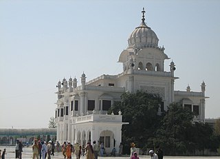
Dera Baba Nanak is a town and a municipal council in Gurdaspur district, in the state of Punjab, India. It is the sub-district headquarters of Dera Baba Nanak tehsil. It is 36 km away from Gurdaspur city, the capital of the district. Since November 2019, a corridor between India and Pakistan has been established at its shrine.

Nadaun is a historical town and a nagar panchayat in the Hamirpur district of Himachal Pradesh, India. Previously a part of the princely state of Kangra, Nadaun is presently an independent small town located on NH 3 and NH 303 in the Sivalik range foothills. It is situated on the banks of the Beas.

<span class="mw-page-title-main">Sultanpur Lodhi</span> City in Punjab, India

Sultanpur Lodhi is a city and a Municipal Council in the Kapurthala district in the Indian state of Punjab. The town is named after its founder, Bahlol Lodhi, the future Sultan of Delhi who renamed the town in 1443 C.E. during his time as governor of Punjab, and has also been mentioned in the Ain-e-Akbari. Sultanpur Lodhi is located on the south bank of a seasonal rivulet called Kali Bein, which runs 6 miles (9.7 km) north of the confluence of the Beas and Sutlej rivers of Punjab.

Pubowal is a village in Una district in the Indian state of Himachal Pradesh.

Narur, also known as Naroor and sometimes Naror, is a large village in Punjab, situated 17 km from Phagwara. The area is 183 hectares with a population of 2485.

Dhudike is a village in Moga Tehsil in Moga district of Punjab state, India. It is located 17 km east from city of Moga, the district headquarter. Freedom fighters like Baba Ishar Singh, Baba Pala Singh Jathedar, Baba Pakhar Singh are a few of the Gadaree from Dhudike who participated in the Gadar Movement during the struggle for independence. Dhudike was the birthplace of the famous Lala Lajpat Rai.

Amb is a town situated in the district of Una in Himachal Pradesh state of India. It is situated in the Shivalik region of Indian subcontinent. It is a sub-division and tehsil of Una district. The town was named Amb after the name of the goddess Amba, deity situated in nearby Chintpurni.

<span class="mw-page-title-main">Panjab Digital Library</span> Organization digitizing and preserving Punjabs cultural heritage

The Panjab Digital Library is a voluntary organization digitizing and preserving the cultural heritage of Panjab since 2003. With over 65 million digitized pages, it is the biggest resource of digital material on Panjab. There are many historically significant documents stored and made available online. Its scope covers Sikh and Punjabi culture. The library funded by The Nanakshahi Trust was launched online in August 2009. Its base office is located at Chandigarh, India.

<span class="mw-page-title-main">Sri Chand</span> Guru Nanaks elder son (1494–1629)

Sri Chand, also referred to as Baba Sri Chandra or Bhagwan Sri Chandra, was the founder of the Udasi sect of ascetic Sadhus. Sikh sources give his life the impressive dates of 8 September 1494 – 13 January 1629, which would have made him 134 years old upon his death.

Kuneran is a village in the Una district within the Indian state of Himachal Pradesh.

Apra also known as The Golden City Apra is a census town in Phillaur Tehsil in Jalandhar district of Punjab State, India. The town is known for gold jewelry and paddy crops which are produced in large amounts. It is located 46 kilometres (29 mi) towards East from Jalandhar, 12 kilometres (7.5 mi) from Phillaur and 110 kilometres (68 mi) from Chandigarh. Apra is the largest town as compared to other surrounding villages and has the main marketplace. The town is administrated by Sarpanch an elected representative of the village.

Nagar is a village in the Phillaur tehsil of Jalandhar District of the Indian state of Punjab. It is located on Phillaur-Nawanshahr Road, 6.7 kilometres (4.2 mi) from the head postal office in Phillaur, 7 kilometres (4.3 mi) from Apra, 50 kilometres (31 mi) from Jalandhar, and 117 kilometres (73 mi) from the state capital of Chandigarh. The village is administered by the Sarpanch, an elected representative.

<span class="mw-page-title-main">Vadbhag Singh Sodhi</span> Direct descendant of Guru Hargobind. Prominent figure in Dhirmalia Sikhism

Vadbhag Singh Sodhi was a direct descendant of Guru Hargobind and a prominent figure of the heretical Dhirmalia sect of Sikhism.

<span class="mw-page-title-main">Sahib Singh Bedi</span> Descendant of Guru Nanak

Sahib Singh Bedi was a direct lineal descendant of Guru Nanak in the tenth generation.

References

  1. "Kila Baba Sahib Singh Ji Bedi Una Sahib". HP Tours. Retrieved 16 May 2018.
  2. Falling Rain Genomics, Inc - Una
  3. "India heatwave temperatures pass 50 Celsius". Phys.org. 2 June 2019. Retrieved 2 June 2019.
  4. "Station: Una Climatological Table 1981–2010" (PDF). Climatological Normals 1981–2010. India Meteorological Department. January 2015. pp. 775–776. Archived from the original (PDF) on 5 February 2020. Retrieved 15 February 2020.
  5. "Extremes of Temperature & Rainfall for Indian Stations (Up to 2012)" (PDF). India Meteorological Department. December 2016. p. M73. Archived from the original (PDF) on 5 February 2020. Retrieved 15 February 2020.
  6. "Table C-01 Population by Religion: Uttar Pradesh". censusindia.gov.in. Registrar General and Census Commissioner of India. 2011.
  7. 1 2 3 "Una Population Census 2011". Census 2011 India. Retrieved 28 April 2018.
  8. "National Highways in Himachal Pradesh" (PDF). Himachal Pradesh Public Works Department. Retrieved 23 May 2018.
  9. "DERA BABA BARBHAG SINGH – MAIRI | District Una, Government of Himachal Pradesh | India" . Retrieved 2 November 2023.