Una district

Last updated

Una District
Chintpurni Devi (17).JPG
Chintpurni Devi Temple
Una in Himachal Pradesh (India).svg
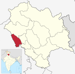
Location in Himachal Pradesh
Coordinates(Una, Himachal Pradesh, India): 31°28′34″N76°16′13″E / 31.47611°N 76.27028°E / 31.47611; 76.27028
CountryFlag of India.svg  India
State Flag placeholder.svg Himachal Pradesh
Established1 September 1972
Headquarters Una
Tehsils 5
Government
   Parliamentary Constituency Hamirpur
   Member of Parliament Anurag Thakur
Area
  Total1,540 km2 (590 sq mi)
Population
 (2011)
  Total521,173
  Density340/km2 (880/sq mi)
   Urban
8.8%
Demographics
   Literacy 87.23%
  Sex ratio977
Time zone UTC+05:30 (IST)
Vehicle registration HP-72 (District RTO)
Average annual precipitation1253 mm
Website http://hpuna.nic.in/

Una district is a district in the Indian state of Himachal Pradesh. Una shares its border with the Hoshiarpur and Rupnagar districts of Punjab and Kangra, Hamirpur, and Bilaspur districts of Himachal Pradesh. The terrain is generally plain with semi hills.

Contents

Una has five tehsils, namely Ghanari, Haroli, Amb, Bangana and Una itself. It was a tehsil of Hoshiarpur district until the Punjab Reorganisation Act, 1966 and Kangra district until 1972, after which it became a district of Himachal Pradesh.

Geography

Tehsils of Una district Tehsils of district una himachal pradesh.jpg
Tehsils of Una district

Una lies in the western part of Himachal Pradesh, with the Sivalik Hills of the Himalayas rolling on the western side and Solah Singhi range on the eastern side. The Satluj river alongside Shahtalai, known for the shrine of Baba Balak Nath passes through south of district near Nangal Dam and Beas passes at the north of district near Pong Dam, Talwara.

The altitude varies from more than 409 meters in plains to over 1000 meters in hills. Swan River which is basically seasonal river and also known as soul of district Una flows 65 km right across the Jaswan Valley towards south until it submerges in the Sutlej river near Anandpur. [1]

Demographics

Historical population
YearPop.±% p.a.
1901165,000    
1911161,786−0.20%
1921161,856+0.00%
1931170,620+0.53%
1941194,249+1.31%
1951196,829+0.13%
1961226,696+1.42%
1971261,357+1.43%
1981317,422+1.96%
1991378,269+1.77%
2001448,273+1.71%
2011521,173+1.52%
source: [2]

According to the 2011 census, Una district has a population of 521,173, [3] giving it a ranking of 543rd in India (out of a total of 640). [3] The district has a population density of 338 inhabitants per square kilometre (880/sq mi). [3] Its population growth rate over the decade 2001-2011 was 16.24%. [3] Una has a sex ratio of 977 females for every 1000 males, [3] and a literacy rate of 87.23%. 8.62% of the population lives in urban areas. Scheduled Castes and Scheduled Tribes make up 22.16% and 1.65% of the population, respectively. [3]

Religions in Una district (2011) [4]
ReligionPercent
Hinduism
92.13%
Sikhism
4.99%
Islam
2.74%
Other or not stated
0.14%

Language

Languages of Una district (2011) [5]

   Hindi (39.51%)
   Punjabi (29.68%)
   Pahadi (23.40%)
   Haryanvi (3.34%)
   Dogri (1.01%)
  Others (3.06%)

Local languages are Hindi, Punjabi and Pahari. Punjabi is mostly used in plain areas of Tehsil Ghanari, Haroli Tehsil, Tehsil Una, and parts of Tehsil Amb. In other areas like Tehsil Bangana and Chintpurni (Part of Amb Tehsil) Pahari dialect is spoken. [5]

Politics

No.ConstituencyMemberPartyRemarksReference
41 Chintpurni (SC) Balbir Singh Bhartiya Janata Party Chairman, Human Development Committee
42 Gagret Rajesh Thakur Bhartiya Janata Party
43 Haroli Mukesh Agnihotri Indian National Congress Leader Of Opposition
44 Una Satpal Raizada Indian National Congress
45 Kutlehar Virender Kanwar Bhartiya Janata Party Rural Development & Panchayati Raj Minister

Education

Schools

Places near Una

Notes

    Related Research Articles

    <span class="mw-page-title-main">Himachal Pradesh</span> State in northern India

    Himachal Pradesh is a state in the northern part of India. Situated in the Western Himalayas, it is one of the thirteen mountain states and is characterised by an extreme landscape featuring several peaks and extensive river systems. Himachal Pradesh is the northernmost state of India and shares borders with the union territories of Jammu and Kashmir and Ladakh to the north, and the states of Punjab to the west, Haryana to the southwest, Uttarakhand to the southeast and a very narrow border with Uttar Pradesh to the south. The state also shares an international border to the east with the Tibet Autonomous Region in China. Himachal Pradesh is also known as Dev Bhoomi or Dev Bhumi, meaning 'Land of Gods' and Veer Bhoomi which means 'Land of the Brave'.

    <span class="mw-page-title-main">Kangra district</span> District in Himachal Pradesh, India

    Kangra district is the most populous district of the Indian state of Himachal Pradesh. Dharamshala is the administrative headquarters of the district.

    <span class="mw-page-title-main">Hamirpur district, Himachal Pradesh</span> A district in Himachal Pradesh, India

    Hamirpur district is in the Indian state of Himachal Pradesh. The headquarters of the district are in the town of Hamirpur. With an area of 1,118 square kilometres or 432 square miles, it is the smallest district of Himachal Pradesh.

    <span class="mw-page-title-main">Sirmaur district</span> A district in Himachal Pradesh, India

    Sirmaur district is the southernmost district of Himachal Pradesh, northern India. It is largely mountainous and rural, with 90% of its population living in villages. Some of its towns include the capital Nahan, Paonta Sahib, LANA PALAR, Tuheri, Bhawan, Shamra, UchaTikker and Suketi, the latter known for Shivalik Fossil Park.

    <span class="mw-page-title-main">Chamba district</span> A district in Himachal Pradesh, India

    Chamba district is the northwestern district of Himachal Pradesh, in India, with its headquarters in Chamba town. The towns of Dalhousie, Khajjhiar and Churah Valley are popular hill stations and vacation spots for the people from the plains of northern India.

    <span class="mw-page-title-main">Mandi district</span> A district in Himachal Pradesh, India

    Mandi district is one of the central districts of Himachal Pradesh state in northern India. The town of Mandi is the headquarters of the district.

    <span class="mw-page-title-main">Hoshiarpur district</span> District in Punjab, India

    Hoshiarpur district is a district of Punjab state in northern India. Hoshiarpur, one of the oldest districts of Punjab, is located in the North-east part of the Punjab state and shares common boundaries with Gurdaspur district in the north-west, Jalandhar district and Kapurthala district in south-west, Kangra district and Una district of Himachal Pradesh in the north-east. Hoshiarpur district comprises 4 sub-divisions, 10 community development blocks, 9 urban local bodies and 1417 villages. The district has an area of 3365 km2. and a population of 1,586,625 persons as per census 2011.

    <span class="mw-page-title-main">Una, Himachal Pradesh</span> City in Himachal Pradesh, India

    Una is a City and a Municipal Council in Una district in the Indian state of Himachal Pradesh. It serves as the headquarters of Una district. There are 11 wards under Municipal Council. Una City is home to the Kila, which is a historical fort and an ancestral home of the descendants of the first guru of the Sikhs, Guru Nanak.

    <span class="mw-page-title-main">Punjab Province (British India)</span> Province of British India

    British Punjab was a province of British India. Most of the Punjab region was annexed by the British East India Company on 29 March 1849, and declared a province of British rule; it was one of the last areas of the Indian subcontinent to fall under British control. In 1858, the Punjab, along with the rest of British Raj, came under the direct rule of the British Crown. It had a land area of 358,355 square kilometers.

    <span class="mw-page-title-main">East Punjab</span> Former province of India from 1947 to 1950

    East Punjab was a province of India from 1947 until 1950. It consisted parts of the Punjab province that remained in India following the partition of the province between the new dominions of Pakistan and the Indian Union by the Radcliffe Commission in 1947. The mostly Muslim western parts of the old Punjab became Pakistan's West Punjab, later renamed as Punjab Province, while the mostly Hindu and Sikh eastern parts remained with India.

    <span class="mw-page-title-main">Shimla district</span> District of Himachal Pradesh in India

    Shimla district is one of the twelve districts of the state of Himachal Pradesh in northern India. Its headquarters is the state capital of Shimla. Neighbouring districts are Mandi and Kullu in the north, Kinnaur in the east, Uttarakhand in the southeast, Solan to the southwest and Sirmaur in the south. The elevation of the district ranges from 987 metres (3,238 ft) to 4,500 metres (14,764 ft).

    Gagret is a nagar panchayat in Tehsil Ghanari of Una district in the state of Himachal Pradesh, India. It is situated in plains of Una.

    Punjab is home to 2.3% of India's population; with a density of 551 persons per km2. According to the provisional results of the 2011 national census, Punjab has a population of 27,743,338, making it the 16th most populated state in India. Of which male and female are 14,639,465 and 13,103,873 respectively. 32% of Punjab's population consists of Dalits. In the state, the rate of population growth is 13.9% (2011), lower than national average. Out of total population, 37.5% people live in urban regions. The total figure of population living in urban areas is 10,399,146 of which 5,545,989 are males and while remaining 4,853,157 are females. The urban population in the last 10 years has increased by 37.5%. According to the 2011 Census of India, Punjab, India has a population of around 27.7 million.

    Amb is a town situated in the district of Una in Himachal Pradesh state of India. It is situated in the Shivalik region of Indian subcontinent. It is a sub-division and tehsil of Una district. The town was named Amb after the name of the goddess Amba, deity situated in nearby Chintpurni.

    Religion in the Punjab in ancient history was characterized by Hinduism and later conversions to Jainism, Buddhism, Islam, Sikhism and Christianity; it also includes folk practices common to all Punjabis regardless of the religion they adhere to. Such practices incorporate local mysticism, including ancestral worship and worship of local saints of all faiths.

    <span class="mw-page-title-main">Pathankot district</span> District of Punjab in India

    Pathankot district is the northernmost district of the Indian state of Punjab. Pathankot is the district headquarters. The district was created on July 27, 2011.

    <span class="mw-page-title-main">Ghanari</span> Place in Himachal Pradesh, India

    Ghanari is the headquarter of Tehsil Ghanari in Una district of Himachal Pradesh, India. It comes under Gagret vidhan sabha constituency and shares border with Punjab and lies on the bank of the seasonal Swan River. It is situated in plains of District Una.

    Elections to the Himachal Pradesh Legislative Assembly were held in February 1967 to elect members of the 60 constituencies in Himachal Pradesh, India. The Indian National Congress won the popular vote and a majority of seats and Yashwant Singh Parmar was re-appointed as the Chief Minister of Himachal Pradesh.

    <span class="mw-page-title-main">1952 Himachal Pradesh Legislative Assembly election</span>

    Legislative Assembly elections were held in Himachal Pradesh in 1952.

    Sunhani is a village located in Jhanduta tehsil of Bilaspur, Himachal Pradesh, India. At the 2001 Census of India, it had a population of 2134 people and 452 families. It was the capital of the Kahlur kingdom from 1600-1650. Throughout history it has played an important role in the local area.

    References

    1. "Swan River". Archived from the original on 1 October 2012.
    2. Decadal Variation In Population Since 1901
    3. 1 2 3 4 5 6 "District Census Handbook: Una" (PDF). censusindia.gov.in. Registrar General and Census Commissioner of India. 2011.
    4. "Table C-01 Population by Religion: Himachal Pradesh". censusindia.gov.in. Registrar General and Census Commissioner of India. 2011.
    5. 1 2 "Table C-16 Population by Mother Tongue: Himachal Pradesh". www.censusindia.gov.in. Registrar General and Census Commissioner of India.
    6. "हिमाचल प्रदेश: स्कूल बस दुर्घटनाग्रस्त, अध्यापिका समेत 6 बच्चे घायल". Amar Ujala (in Hindi). 19 November 2018. Retrieved 15 March 2022.
    7. 1 2 3 4 5 6 7 8 9 "Schools - Himachal Pradesh" (PDF). himachal.nic.in. Retrieved 25 April 2022.
    8. "Vashist Public School, Behdala, Una: Admission, Fee, Facilities, Affiliation". school.careers360.com. Retrieved 1 March 2022.