
College Hill is a historic neighborhood of Providence, Rhode Island, and one of six neighborhoods comprising the city's East Side. It is roughly bounded by South and North Main Street to the west, Power Street to the south, Governor Street and Arlington Avenue to the east and Olney Street to the north. The neighborhood's primary commercial area extends along Thayer Street, a strip frequented by students in the Providence area.

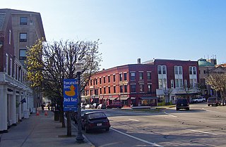
Downtown is the central economic, political, and cultural district of the city of Providence, Rhode Island. It is bounded on the east by Canal Street and the Providence River, to the north by Smith Street, to the west by Interstate 95, and to the south by Henderson Street. I-95 serves as a physical barrier between the city's commercial core and neighborhoods of Federal Hill, West End, and Upper South Providence. Most of the downtown is listed on the National Register of Historic Places as the Downtown Providence Historic District.

Barrington Civic Center Historic District is a historic district in Barrington, Rhode Island on County Road. The district, which consists of the Barrington Town Hall, Leander R. Peck School and Prince's Hill Cemetery, is located on Prince's Hill near the center of Barrington. In 1728, Prince's Hill Cemetery was purchased and later expanded to its present size by 1898. The 1 1⁄2-story Barrington Town Hall was completed in 1888 and originally served as the seat of the town's government, library and high school. With the completion of the Leander R. Peck School in 1917, the high school moved into the adjacent building and the library used its space. The two-story Elizabethan Revival style Peck School is designed with a T-shaped plan and features a stairway to access the main entrance on the second story. The Peck School was later used by the fifth and sixth-grade elementary students before becoming the public library. Also located within the district is Wood's Pond. The Barrington Civic Center Historic District was added to the National Register of Historic Places in 1976 and serves as a historically significant example of civic and natural environment planning of the late nineteenth century.
The Westerly Downtown Historic District is a historic district encompassing most of the commercial and civic district of Westerly, Rhode Island, United States. It extends from Broad and Union Streets eastward along High Street, and north along Canal Street to Railroad Avenue, where it extends to include the historic railroad station. The district contains a compact and cohesive collection of commercial and civic buildings built primarily during the last three decades of the 19th century and the first three decades of the 20th century, including the Old Town Hall (1872–74), the current Town Hall (1912), the Spanish Colonial railroad station (1912), and the Greek Revival post office (1914).
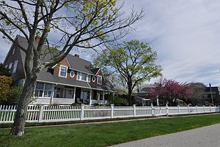
Buttonwoods Beach Historic District is a historic district bounded by Brush Neck Cove, Greenwich Bay, Cooper and Promenade Avenues in Warwick, Rhode Island. "Old Buttonwoods" is a bucolic neighborhood on the eastern limb of the Nausauket neck, located in the West Bay area of Warwick, Rhode Island. Buttonwoods is delimited by Nausauket and Apponaug to the west, Buttonwoods Cove to the north, Greenwich Bay to the south and Oakland Beach to the east. The Old Buttonwoods section of Warwick was founded as a summer colony in 1871 by the Rev. Moses Bixby of Providence's Cranston Street Baptist Church, who was looking for a place to establish a summer colony by the shore for his congregation. He envisioned a community that would be similar to Oak Bluffs on Martha's Vineyard, where the Methodists established a summer campground in 1835. Today, this coastal neighborhood on Greenwich Bay is home to people from many different religious backgrounds.

The Kent County Courthouse, now the East Greenwich Town Hall, is a historic court building at 127 Main Street in East Greenwich, Rhode Island.
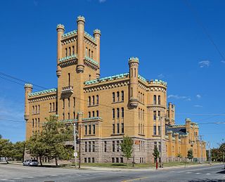
The Cranston Street Armory is an historic building in the Broadway–Armory Historic District of Providence, Rhode Island. It was built in 1907 at a cost of $650,000.00. The building was occupied by the Rhode Island National Guard from its opening until 1996. Since then, parts of the building have been used as film studios, and some of its offices occupied by the Rhode Island State Fire Marshal. The National Trust for Historic Preservation listed the Armory as one of "America's 11 Most Endangered Historic Places" in its annual list for 1997. Its distinctive yellow bricks, crenellated turrets, and decorative stonework mark it as a historically significant building and neighborhood icon.

Stephen Carpenter Earle was an architect who designed a number of buildings in Massachusetts and Connecticut that were built in the late 19th century, with many in Worcester, Massachusetts. He trained in the office of Calvert Vaux in New York City. He worked for a time in partnership with James E. Fuller, under the firm "Earle & Fuller". In 1891, he formed a partnership with Vermont architect Clellan W. Fisher under the name "Earle & Fisher".

John Holden Greene (1777-1850) was a noted early nineteenth century architect practicing in Providence, Rhode Island. The bulk of his work dates to the late Federal period, and is mostly in the architectural style of the same name. Greene is responsible for the design of over fifty buildings built in the city between 1806 and 1830, almost half of which are still standing.
William R. Walker & Son was an American architectural firm in Providence, Rhode Island, active during the years 1881 to 1938. It included partners William Russell Walker (1830–1905), William Howard Walker (1865–1922), and later, William Russell Walker II (1889–1936).

Martin & Hall was the architectural partnership of Frank W. Martin and George F. Hall (1866–1928). It was based in Providence, Rhode Island.

Alpheus Carey Morse was an American architect, with offices in Providence, Rhode Island.
Jackson, Robertson & Adams was an architectural firm out of Providence, Rhode Island. Established in 1912, it was originally made up of architects F. Ellis Jackson (1879-1950), Wayland T. Robertson (1873-1935), and J. Howard Adams (1876-1924).
Howard Hoppin was an American architect from Providence, Rhode Island.

James C. Bucklin (1801-1890) was an American architect working in Providence, Rhode Island.

Clarke & Howe was an American architectural firm from Providence, Rhode Island that was active from 1893 to 1928.

Wallis Eastburn Howe (1868–1960) was a notable American architect from Rhode Island.

William R. Walker was an American architect from Providence, Rhode Island, who was later the senior partner of William R. Walker & Son.

The Cumberland Town Hall District is a historic district encompassing two buildings of civic and architectural significance in Cumberland, Rhode Island. It includes Cumberland's town hall, located at 45 Broad Street in the village of Valley Falls, and an adjacent commercial building at 16 Mill Street, which was historically used for commercial and civic functions. The town hall, built in 1894, was the town's first purpose-built municipal building, and is a prominent example of Colonial Revival architecture, designed by Rhode Island architect William R. Walker. The district was listed on the National Register of Historic Places in 2019.
Colonel Francis Laurens Vinton Hoppin was a prominent American architect and painter from Providence, Rhode Island.


