Wingina, Virginia

Last updated

Wingina is an unincorporated community in Nelson County, Virginia, United States.

Nelson County, Virginia County in the United States

Nelson County is a county located in the Commonwealth of Virginia. As of the 2010 census, the population was 15,020. Its county seat is Lovingston.

Virginia State of the United States of America

Virginia, officially the Commonwealth of Virginia, is a state in the Southeastern and Mid-Atlantic regions of the United States located between the Atlantic Coast and the Appalachian Mountains. The geography and climate of the Commonwealth are shaped by the Blue Ridge Mountains and the Chesapeake Bay, which provide habitat for much of its flora and fauna. The capital of the Commonwealth is Richmond; Virginia Beach is the most populous city, and Fairfax County is the most populous political subdivision. The Commonwealth's estimated population as of 2018 is over 8.5 million.

United States Federal republic in North America

The United States of America (USA), commonly known as the United States or America, is a country comprising 50 states, a federal district, five major self-governing territories, and various possessions. At 3.8 million square miles, the United States is the world's third or fourth largest country by total area and is slightly smaller than the entire continent of Europe's 3.9 million square miles. With a population of over 327 million people, the U.S. is the third most populous country. The capital is Washington, D.C., and the largest city by population is New York City. Forty-eight states and the capital's federal district are contiguous in North America between Canada and Mexico. The State of Alaska is in the northwest corner of North America, bordered by Canada to the east and across the Bering Strait from Russia to the west. The State of Hawaii is an archipelago in the mid-Pacific Ocean. The U.S. territories are scattered about the Pacific Ocean and the Caribbean Sea, stretching across nine official time zones. The extremely diverse geography, climate, and wildlife of the United States make it one of the world's 17 megadiverse countries.

Contents

The Wingina Store 2016-05-27 10 22 09 The Wingina Store in Wingina, Nelson County, Virginia.jpg
The Wingina Store

History

This area was originally inhabited by Monacan Indians. The Monacan tribe and their allies, the Mannahoac, had settled central Virginia from the Rappahannock River to the James River for at least 500 years before the English arrived in Virginia. As the English encroached farther west into what is now central Virginia, the Indians dispersed to the north, south, and west. In the 19th century a number of Monacans created a settlement at Bear Mountain in Amherst County, where many of the tribe live today. The Saponi and Tutelo Indians are also remnants of this main confederacy. This village located on the banks of the James River between Buckingham and Nelson counties was part of the original land grant of Dr. William Cabell in 1735. Dr. Cabell received the grant of 25,000 acres from King George II. The Europeans first called this area "Hardwicksville".

Rappahannock River river in Virginia, United States

The Rappahannock River is a river in eastern Virginia, in the United States, approximately 195 miles (314 km) in length. It traverses the entire northern part of the state, from the Blue Ridge Mountains in the west where it rises, across the Piedmont to the Fall Line, and onward through the coastal plain to flow into the Chesapeake Bay, south of the Potomac River.

James River river in Virginia, United States

The James River is a river in the U.S. state of Virginia that begins in the Appalachian Mountains and flows 348 miles (560 km) to Chesapeake Bay. The river length extends to 444 miles (715 km) if one includes the Jackson River, the longer of its two source tributaries. It is the longest river in Virginia and the 12th longest river in the United States that remains entirely within a single state. Jamestown and Williamsburg, Virginia’s first colonial capitals, and Richmond, Virginia's current capital, lie on the James River.

Amherst County, Virginia County in the United States

Amherst County is a county, located in the Piedmont region and near the center of the Commonwealth of Virginia in the United States. The county is part of the Lynchburg, VA Metropolitan Statistical Area, and its county seat is also called Amherst.

The small town of Wingina is located south of Lovingston, situated on James River Road (SR 56) at the James River Bridge and the C&O railroad (known as Wingina Station), where the Wingina Post office and general store now stands. On the western side of Rte. 56 are the areas known as Union Hill and Norwood. On the eastern side of this road are the areas known as Midway Mills, Warminster, and Edgewood. This entire area was owned by the Cabell family.

Lovingston, Virginia Place in Virginia, United States

Lovingston is a census-designated place (CDP) in and the county seat of Nelson County, Virginia, United States. The population as of the 2010 Census was 520. Its ZIP Code is 22949. It was among the communities severely affected by flash flooding from Hurricane Camille in 1969.

Virginia State Route 56 highway in Virginia

State Route 56 is a primary state highway in the U.S. state of Virginia. The state highway runs 60.87 miles (97.96 km) from U.S. Route 11 at Steeles Tavern east to US 60 near Buckingham. SR 56 is the main east–west highway of Nelson County. The state highway connects the county seat of Lovingston with Buckingham to the east and the Blue Ridge Mountains and the Shenandoah Valley to the west.

About five miles above this area on this same road, heading towards the town of Shipman, is Glade Rd., also known as Secretary's Rd. and "Warriors Path". This road was used by the Monacan and Powhatan Confederations for hunting and war between the local tribes, consisting of Siouan-speaking (Monacan and Mannahoac) and Iroquoian-speaking groups (Cherokee). Beginning as a dirt path through the wilderness, the road was formed by the natives walking in single file. Their feet were set down from heel to toe, the advancing foot always on the line with their rear foot. The years of single file journeys had worn a deep narrow trail, crossing streams where fords were established. This trail stretched from the Rockfish River, down through Findlay's Gap into Amherst. As the area began to grow with early white settlers, this main Indian trail was widened and maintained by the local African slaves to accommodate horses and oxen, then to provide access to stagecoaches and wagons.

In 1853, the canal company owned by Joseph Carrington Cabell built a covered wooden bridge over the James River at Wingina, which was used during the American Civil War. The bridge was eventually burned by the Confederate army to prevent General Sheridan's army from crossing in their effort to cut off General Lee's retreat to Petersburg.

In 1880, the Richmond Allegheny Railroad purchased the property around the canal and named this area "Wingina" after a Secotan Indian chief of the 16th century who resisted the encroachment of the Europeans.

In 1890, the Chesapeake and Ohio Railroad (C&O) acquired the property, and in 1905 the company constructed a steel-trussed bridge over the James River on the original stone piers of the earlier wooden bridge.

In 1920, the Johnson family, who owned a building supply store, moved from Buckingham County over to Wingina and established the Wingina General Store and Post Office. The store supplied the railroad ties for the C&O railroad. John Yarborough served as the first postmaster. The general store closed in 1991 but the post office still services areas of Buckingham, Norwood and Wingina. [1]

Edgewood and Soldier's Joy are listed on the National Register of Historic Places. [2]

Edgewood (Wingina, Virginia) historic farm complex located at Wingina, Nelson County, Virginia

Edgewood is a historic farm complex located at Wingina, Nelson County, Virginia. Structures located on the 65-acre (260,000 m2) property document its evolution as a plantation and farm since the late-18th century. It includes the main house ruins, a house built about 1790 and destroyed by fire in 1955; the circa 1820 Tucker Cottage; an 18th-century dovecote, dairy, and smokehouse; an 1828 icehouse; an early 19th-century corncrib; and a mid-19th-century barn or granary. Also on the property are a circa 1940's tenant house and machine shed, the Cabell family cemetery, and an original well. The structures are all located along the gravel driveway.

Soldiers Joy (house) human settlement in Virginia, United States of America

Soldier's Joy is a historic house located at Wingina, Nelson County, Virginia, USA. It was built in 1784–85 by Col. Samuel Jordan Cabell and enlarged approximately twenty-five years later. Along with Bon Aire and Montezuma, it is one of the few remaining Cabell family houses in Nelson County. When constructed it was a five-part Palladian house; reduced in size during the 20th century when the early 19th-century wings were moved. The Late-Georgian dwelling is distinguished by its fine proportions and interior detailing, much of which was added when the house was enlarged. The elaborate woodwork from the ballroom wing was removed to the Cincinnati Art Museum when the house was renovated in the 1920s.

National Register of Historic Places federal list of historic sites in the United States

The National Register of Historic Places (NRHP) is the United States federal government's official list of districts, sites, buildings, structures, and objects deemed worthy of preservation for their historical significance. A property listed in the National Register, or located within a National Register Historic District, may qualify for tax incentives derived from the total value of expenses incurred preserving the property.

Related Research Articles

Powhatan County, Virginia County in the United States

Powhatan County is a county located in the Commonwealth of Virginia. As of the 2010 census, the population was 28,046. Its county seat is Powhatan.

Fluvanna County, Virginia County in the United States

Fluvanna County is a county located in the Piedmont region of the Commonwealth of Virginia. As of the 2010 census, the population was 25,691. Its county seat is Palmyra.

Buckingham County, Virginia County in the United States

Buckingham County is a rural United States county located in the Commonwealth of Virginia, and containing the geographic center of the state. Buckingham County is part of the Piedmont region of Virginia, and the county seat is the town of Buckingham.

Amherst, Virginia Town in Virginia, United States

Amherst is a town in Amherst County, Virginia, United States. The population was 2,231 at the 2010 census. It is the county seat of Amherst County.

Shenandoah Valley valley and cultural region of western Virginia and the Eastern Panhandle of West Virginia in the United States

The Shenandoah Valley is a geographic valley and cultural region of western Virginia and the Eastern Panhandle of West Virginia in the United States. The valley is bounded to the east by the Blue Ridge Mountains, to the west by the eastern front of the Ridge-and-Valley Appalachians, to the north by the Potomac River and to the south by the James River. The cultural region covers a larger area that includes all of the valley plus the Virginia highlands to the west, and the Roanoke Valley to the south. It is physiographically located within the Ridge and Valley province and is a portion of the Great Appalachian Valley.

William Cabell was an American statesman, soldier, and politician.

Samuel Jordan Cabell was an American Revolutionary war officer and Democratic-Republican United States Congressman from 1795 to 1803.

Midlothian, Virginia Unincorporated area in Virginia, United States

Midlothian, Virginia is an unincorporated area in Chesterfield County, Virginia, U.S. Settled as a coal town, Midlothian village experienced suburbanization effects and is now part of the western suburbs of Richmond, Virginia south of the James River in the Greater Richmond Region. Because of its unincorporated status, Midlothian has no formal government, and the name is used to represent either the original small Village of Midlothian, located near US-60 and Woolridge Road, or a vast expanse of Chesterfield County in the northwest portion of Southside Richmond covered by three zip codes served by the Midlothian post office. These zip codes are not coterminous with the Midlothian Magesterial District associated with the Chesterfield County government.

The Monacan Indian Nation is one of eleven Native American tribes recognized by the Commonwealth of Virginia in the United States. In January 2018, Congress passed an act to provide federal recognition as tribes to the Monacan and five other tribes in Virginia.

The Manahoac, also recorded as Mahock, were a small group of Siouan-language American Indians in northern Virginia at the time of European contact. They numbered approximately 1,000 and lived primarily along the Rappahannock River west of modern Fredericksburg and the Fall Line, and east of the Blue Ridge Mountains. They united with the Monacan, the Occaneechi, the Saponi and the Tutelo. They disappeared from the historical record after 1728.

Native American tribes in Virginia indigenous tribes who currently live or historically lived in what is now the Commonwealth of Virginia, United States of America

The Native American tribes in Virginia are the indigenous tribes who currently live or have historically lived in what is now the Commonwealth of Virginia in the United States of America.

James Garland was a nineteenth-century politician, military officer, planter, lawyer an judge from Virginia.

U.S. Route 29 in Virginia highway in Virginia

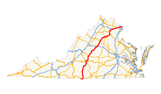
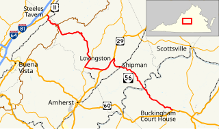
U.S. Route 29 is a major north–south route in the Commonwealth of Virginia. It covers 248 miles (399 km) from the North Carolina border at the city of Danville to the Key Bridge in Washington, D.C.. US 29 roughly bisects Virginia into eastern and western halves, and along with Interstate 81 in western Virginia, and 85/95 farther east, provides one of the major north–south routes through the Commonwealth.

Midway Mills is an unincorporated community in Nelson County, Virginia, United States. Midway, now called Midway Mills, was established on June 6, 1774, by Dr. William Cabell,, and was the first European settlement in Nelson County. It was named Midway because it was midway between Richmond and Lynchburg along the James River. The area, at that time part of "Old Albemarle County", was later divided into the counties of Albemarle, Amherst, Buckingham, Nelson, and Fluvanna between 1741 and 1809.

Tye River river in the United States of America

The Tye River is a 35.4-mile-long (57.0 km) tributary of the James River in central Virginia in the United States. Originating on the eastern slope of the Blue Ridge Mountains in Nelson County, and fed by the Piney and Buffalo rivers, by way of the James River it is part of the watershed of the Chesapeake Bay.

Rock Cliff

Rock Cliff is a historic farm property at 12615 Norwood Road, near Wingina in Nelson County, Virginia. It consists of 692 acres (280 ha), roughly bounded by Norwood Road on the south, James River Road on the east, and Union Hill Road on the north. The property was developed beginning in 1854, the year the main house, a wood frame I-house, was built. It was developed by Dr. William Horsley, divided amongst his five children, and then reassembled by his grandson. The farm complex also includes a 19th-century smokehouse, kitchen, and doctor's office, as well as the c. 1860 Horsley family cemetery.

References

Citations

  1. From the family research of Derek G. Nicholas, based on a pamphlet discovered in a file cabinet the Lovingston Library in Nelson County, Virginia and the Nelson County Heritage (green book).
  2. National Park Service (2010-07-09). "National Register Information System". National Register of Historic Places . National Park Service.

Other sources

Coordinates: 37°38′24″N78°43′26″W / 37.64000°N 78.72389°W / 37.64000; -78.72389